username
X
password
register
for free!
help
ArticlesGuidesRoutes
 
Photosets
 
 Comments
triplogs   photosets   labels comments more
Guindani Trail - 12 members in 29 triplogs have rated this an average 3.4 ( 1 to 5 best )
1, 2  Next
29 triplogs
login for filter options
Apr 26 2025
avatar

 Guides 17
 Routes 297
 Photos 1,808
 Triplogs 276

female
 Joined Mar 11 2002
 Gilbert, AZ
Guindani TrailTucson, AZ
Tucson, AZ
Hiking avatar Apr 26 2025
VashtiTriplogs 276
Hiking4.90 Miles 1,001 AEG
Hiking4.90 Miles   2 Hrs   37 Mns   2.19 mph
1,001 ft AEG      23 Mns Break
 
1st trip
Linked   none no linked trail guides
Partners none no partners
Route Scout Route Recorded  on Route Scout | Pop | Map | Popup | MapDEX
Wanted to do a hike before our Headlamp cave tour and decided to try this one as we did the foothills loop last time we were in the area.

We got a later start given our car camping tradition of pancake breakfasts! 🥞🥞🏕️❤️ We walked from the campground to the trailhead where there are plenty of spots and informational signs. In the first quarter mile, there are a number of criss-crossing trails, but the main trail is easy to follow. There are also some trail signs, as well. We opted to do the loop CW. At the junction, the trail is an old jeep road and is wide for quite some time, until the trail departs from the jeep road while switchbacking up the ridge. The old jeep road heads up to a mining area, and there is a trail sign in the middle of the old road stating the trail goes the other direction. The trail continues along the side of the ridge continuing up hill until it reaches the saddle.

We stopped for a snack at the saddle and then headed onward, now downwards toward Cottonwood creek. There are some gates along the way. We only saw one person on the entire hike, just before the Cottonwood trail junction.

Before the saddle, it was very windy. The trail is more sheltered and less windy past the saddle, but it made for a hotter hike. The entire hike is full sun. In the wash, there was no water, but quite a bit of lush vegetation. I was surprised to see such big green trees and many wildflowers/flowering shrubs. It was a real treat! The trail crosses the wash a number of times. The trail is labeled with many trail signs in this section.

We came upon a cow trough and water tank as the canyon opened up, and from there it was a short distance to the loop fork and the trailhead.

A nice hike, but it would have been even better if it was cooler/cloudy and just a tad less windy. Picky picky! 🤣😎
wildflower observationwildflower observationwildflower observationwildflower observationwildflower observation
Wildflowers Observation Light
More wild flowers than expected! The ocotillos were all blooming, plus thistle, red sylvia, and tiny purple flowers.

dry Guindani Canyon Dry Dry
_____________________
:D
 
May 25 2024
avatar

 Guides 59
 Routes 1,100
 Photos 1,191
 Triplogs 1,290

male
 Joined Jan 01 2023
 Arizona
Guindani TrailTucson, AZ
Tucson, AZ
Hiking avatar May 25 2024
pseudalpineTriplogs 1,290
Hiking4.29 Miles 985 AEG
Hiking4.29 Miles   1 Hour   49 Mns   2.36 mph
985 ft AEG
 no routesno photosets
1st trip
Linked   none no linked trail guides
Partners none no partners
A bunch of lizards, three Coues whitetail and two snakes, the second a coral. No humans on this loop except us two. The constant winds helped moderate the heat from the intense sun. Better loop than expected.
  9 archives
Mar 09 2023
avatar

 Guides 187
 Routes 990
 Photos 12,079
 Triplogs 865

72 male
 Joined Jun 27 2015
 Tucson, Arizona
Guindani Cottonwood Trail, AZ 
Guindani Cottonwood Trail, AZ
 
Hiking avatar Mar 09 2023
markthurman53Triplogs 865
Hiking9.05 Miles 2,160 AEG
Hiking9.05 Miles   5 Hrs   28 Mns   1.71 mph
2,160 ft AEG      11 Mns Break
 
Partners partners
mamakatt22
Back to the Whetstones this time to hike the Guindani and Cottonwood Saddle Trails. I have done these before about 3 years ago but needed a refresher Coarse on just how nice it is in this area. We starting at Karchner Caverns State Park. Did the Guindani CW direction. The Whetstones are an interesting mountain range, unlike the other ranges in southern Arizona these are pretty much a stack of Sedimentary rocks. After saying that this hike was through the one section that is mainly Cambrian igneous intrusions. Won't bore you with the details but I was excited (Alaskite and Quartz Monzonite oh my). Good amount of water flowing in the streams. Ginny's new boots appeared to work just fine. The weather was in the low 70's in the afternoon with a slight breeze to cool things off a bit.

The Guidani Trail heads up along the south side of a hill that offers great views to the East over San Pedro River Valley and the Dragoon Mountains. To the South overlooking Middle Canyon and The Cape which reminds me of Ramsey Peak in the Huachuca Mountains. After climbing 1000 feet you cross over a saddle and head down into Cottonwood Creek. Multiple mines along the trail are Fluorspar mines active in the early 1900's and as late as 1967. All the rocks of this hill are Alaskite butted up against Pinal Schist.

Once down from the saddle and in Cottonwood creek the Cottonwood Saddle trail heads up stream. Fairly easy trail up to the saddle, a few short lived steep sections. Rocks along the canyon are Quartz Monzonite darker than the light colored Alaskite, both are Precambrian in age. Water was flowing in the creek almost all the way to the saddle. Nothing spectacular at the saddle, in fact I don't even remember being here before, that's how memorable it was. Catalina Mountains and Rincon Mountains can be seen to the north.

Headed back down the way we came up and returned on the Guidani trail in the CW direction. Pretty much follows and crosses the creek many times before exiting to the south and reconnecting with itself. One of the largest ocotillo I have ever seen is along this trail just before completing the loop. The branches/stems were at least 5 inches across it would take both hands to wrap around it if you were so inclined to do that.
_____________________
 
Jun 12 2021
avatar

 Photos 5
 Triplogs 1,041

36 female
 Joined Oct 04 2012
 Phoenix, AZ
Guindani TrailTucson, AZ
Tucson, AZ
Hiking avatar Jun 12 2021
WaitingForRainTriplogs 1,041
Hiking4.30 Miles 1,250 AEG
Hiking4.30 Miles   2 Hrs   6 Mns   2.05 mph
1,250 ft AEG
 no routesno photosets
1st trip
Linked   none no linked trail guides
Partners none no partners
Really loved this trail, even though it kind of kicked my butt on the way up. It was a little too hot and I think I was a bit tired from the night hike before. But it had the best views of the Whetstones and great wildflowers even late in the season. I do wish the Cottonwood Saddle trail was a little more maintained. I would have liked to follow it for a bit, but didn't want to bushwack down the wash on my own.
_____________________
 
Mar 18 2021
avatar

 Routes 85
 Photos 3,718
 Triplogs 486

female
 Joined Oct 15 2002
 Rimrock, Arizona
Guindani TrailTucson, AZ
Tucson, AZ
Hiking avatar Mar 18 2021
cactuscatTriplogs 486
Hiking3.15 Miles 500 AEG
Hiking3.15 Miles
500 ft AEG
 no routesno photosets
1st trip
Linked   none no linked trail guides
Partners none no partners
_____________________
 
May 17 2020
avatar

 Routes 1
 Photos 6
 Triplogs 7

41 female
 Joined Sep 25 2011
 Tucson, AZ
Cottonwood Saddle Trail #386 - WhetstonesTucson, AZ
Tucson, AZ
Hiking avatar May 17 2020
sami_hTriplogs 7
Hiking6.00 Miles
Hiking6.00 Miles   6 Hrs      1.00 mph
 no routesno photosets
1st trip
Linked   linked  
Partners none no partners
A friend and I hiked up the Guindani and Cottonwood Saddle trails to get out of the house and try out SIA's new Spring Seeker app to survey a few springs. Trails were in good shape. Cottonwood saddle was fainter, but still easy to follow. Water at a trough on the trail by Box Artesia Well (actually a hillslope spring piped down from above the trough). Went as far as Basin Spring, which is probably intermittent. We found a tiny pool of water about an inch deep there. Not one to count on for a drink!. A fair bit of water in Guindani canyon off and on though, a pleasant surprise! Probably sprinkled with springs here and there that aren't on the map. Poor pup got overheated the last mile back. I'll be more careful next time.

water 1 out of 5water 2 out of 5water less than maxwater less than max Guindani Box Artesia Well Quart per minute Quart per minute
Not sure of the exact flow rate, but the troughs were full/overflowing. Plenty of water!
_____________________
 
May 13 2020
avatar

 Guides 187
 Routes 990
 Photos 12,079
 Triplogs 865

72 male
 Joined Jun 27 2015
 Tucson, Arizona
Guindani Cottonwood Saddle, AZ 
Guindani Cottonwood Saddle, AZ
 
Hiking avatar May 13 2020
markthurman53Triplogs 865
Hiking8.79 Miles 1,975 AEG
Hiking8.79 Miles   4 Hrs   13 Mns   2.49 mph
1,975 ft AEG      41 Mns Break15 LBS Pack
 
Partners none no partners
I took another short hike close to home but this time in the Whetstone Mountains. I have not been in these mountains in over 30 years, before Karchner Cavern Park even existed. The Guindani Trail starts in the park and exits almost immediately to National Forest. This trail is a 4.3 mile loop that I did clockwise with a side trip up to Cottonwood saddle. Karchner Cavern State Park was empty with only a couple of die hard campers and one other hiker. It turned out to be a great day to do this hike. My original plan was to take a dirt road north of the park that leads to the Ricketts mine and head south to the Guindani Trail to avoid the park mess. The dirt road was blocked off by a gate so I had to change my plan. This is state trust land so I’m not sure what the story is.

The Guindani Trail is in good shape and appears to get a lot of use. In the clock wise direction the climb up to the ridge is done first and then drops down into Guindani Canyon where it intersects the Cottonwood Saddle Trail. There was water intermittently along this canyon. I made the assumption that the Guindani Canyon is north of the hill that the Guindani Trail goes around and that Middle canyon is to the south.

The Cottonwood saddle Trail, 2.2 miles, is also in good condition with only a few sections on the upper end where it gets vague. There are plenty of rock cairns so loosing the trail except momentarily is not an issue. Near the saddle is a spring box and there was a trickle of water there. Views from the saddle are not terrific with the exception of one good view of Rincon Peak to the north, but you have to locate yourself just right between two tree/shrubs.

Surprisingly good weather on this hike with temps in the low 80’s and a good breeze especially on the high spots. I only brought a quart of water with me since this was a short hike. Probably would be wise to take a bit more this time of year. I ended up with a bit left when I finished and I sampled some of the water in the stream also. Always have to give my immune system a workout too.
 Culture
 Culture [ checklist ]
[ checklist ]  Windmill
 Named place
 Named place [ checklist ]
[ checklist ]  The Cape

water 1 out of 5water less than maxwater less than maxwater less than max Guindani Canyon Pools to trickle Pools to trickle
Upper canyon near the Cottonwood Saddle Trail. also along stream intermittently on the Cottonwood Saddle Trail
_____________________
 
Mar 02 2020
avatar

 Guides 4
 Photos 4,732
 Triplogs 2,607

55 male
 Joined Sep 29 2004
 Small Town USA
Guindani TrailTucson, AZ
Tucson, AZ
Hiking avatar Mar 02 2020
SkyIslander18Triplogs 2,607
Hiking5.60 Miles 1,250 AEG
Hiking5.60 Miles
1,250 ft AEG
 no routes
Partners none no partners
Guindani loop clockwise with a little Foothills at the end.
Had a great hike! Excellent scenery, counted many AZ rainbow cactus (my fav) along the way, water was flowing down the canyon & the weather was nice on this early March day.

100+ vehicles in the parking lot, but not a single other hiker encountered today. I guess everyone was there to see the big hole in the ground?

Whetstone Mountains rock!
:D
_____________________
https://www.instagram.com/skyislander22/
 
Feb 14 2015
avatar

 Guides 2
 Routes 6
 Photos 1,167
 Triplogs 298

43 male
 Joined Nov 12 2013
 Phoenix, AZ
Guindani TrailTucson, AZ
Tucson, AZ
Hiking avatar Feb 14 2015
winotronTriplogs 298
Hiking4.57 Miles 1,010 AEG
Hiking4.57 Miles   2 Hrs   30 Mns   2.11 mph
1,010 ft AEG      20 Mns Break3 LBS Pack
 no routes
1st trip
Linked   none no linked trail guides
Partners none no partners
Took another weekend road trip to Southeast AZ. Our main destination was Bisbee, where we stayed for 2 nights, but we had plenty of other things planned on the way there and on the way back. First stop was Kartchner Caverns in Benson, which me and my girlfriend had never been to. Kartchner was awesome, and so was this hike. Wasn't sure what to expect from this hike, but it was a very pleasant surprise for us both.

The weather was completely overcast, which made for a very nice day out, but not a great one for photos. The mesquite forest at the beginning of the trail was really cool. Also some of the biggest ocotillo I've ever seen. A lot of them were even bigger than the surrounding mesquite trees. We chose to do the loop in the direction in the description, CCW. The first mile of the trail was mostly flat and gentle. Then the trail curved back into the mountains and started to climb a bit. We started to hear running water down below. I wasn't really expecting to see any water on this trail, but the creek was flowing pretty heavily! A nice surprise. There were even a few 5-10 ft waterfalls. We were starting to think the trail wouldn't end up going down to the creek at all, but it eventually crossed it several times. Nice to feel the ice cold water. It was hard to cross the creek without getting our feet wet in a couple spots.

Around 2 miles in, the trail started to climb up and out of the canyon, and this half mile was the only steep part of the hike. At the top of that climb, we came to a saddle, and the expansive views to the east really snuck up on us. It stopped us in our tracks and we just enjoyed this spot for a while. I was glad we did the loop in this direction, because we had this view in front of us pretty much the whole way down. Awesome views of the other surrounding sky islands. We only saw 3 other people. Crazy how Kartchner was so crowded, but no one was on this trail. Fine by me! We enjoyed this hike a lot more than expected. Great way to kick off our weekend!
_____________________
  2 archives
Dec 30 2014
avatar

 Guides 4
 Photos 4,732
 Triplogs 2,607

55 male
 Joined Sep 29 2004
 Small Town USA
Guindani TrailTucson, AZ
Tucson, AZ
Hiking avatar Dec 30 2014
SkyIslander18Triplogs 2,607
Hiking7.25 Miles 1,728 AEG
Hiking7.25 Miles
1,728 ft AEG
 no routes
Partners partners
AddSanz
Very enjoyable day spent with Addie & Bianca hiking around Kartchner Caverns!
We hiked the figure 8 starting with Guindani clockwise and ending with the Foothills counter clockwise.
Guindani Trail - 3 javelina encountered on the trail right at the start, many Arizona rainbow cactus found along the southern slopes, snow on the trail along the northern slopes & some decent water pools down the canyon.
Foothills Trail - Not quite as nice as Guindani, but still an enjoyable loop around the caverns.
After our hike, we drove down to the center and tried to get on one of the afternoon cave tours, but with no luck. Booked solid for the rest of the day :(
The drive back home included a stop in Wilcox for a walk down (Rex Allen) Railroad Ave, a stop at Apple Annie's for pie and a very scenic route back to Safford via the Sulphur Springs Valley/Stockton Pass Rd's.
Great ending to 2014. Many, many thanks to the girls for a wonderful year !!!

water 1 out of 5water less than maxwater less than maxwater less than max Guindani Canyon Pools to trickle Pools to trickle
_____________________
https://www.instagram.com/skyislander22/
  1 archive
Mar 10 2014
avatar

 Guides 170
 Routes 148
 Photos 5,914
 Triplogs 2,097

48 male
 Joined Apr 12 2004
 Tucson, AZ
Guindani TrailTucson, AZ
Tucson, AZ
Hiking avatar Mar 10 2014
PrestonSandsTriplogs 2,097
Hiking4.25 Miles 1,250 AEG
Hiking4.25 Miles   1 Hour   45 Mns   3.00 mph
1,250 ft AEG      20 Mns Break8 LBS Pack
 
Linked   none no linked trail guides
Partners none no partners
Plans for a more adventurous hike were ruined due to a tire issue, but I still went to the Whetstones. Did a clockwise loop late in the day and finished up just before dark. Lots of cows and cowpies hanging around Guindani Canyon. Great hike as always.
_____________________
"…you never know when a hike might break out" -Jim Gaffigan
 
Dec 16 2012
avatar

 Photos 261
 Triplogs 8

78 male
 Joined Feb 02 2012
 Green Valley, AZ
Guindani TrailTucson, AZ
Tucson, AZ
Hiking avatar Dec 16 2012
ArizonaBobTriplogs 8
Hiking4.25 Miles 1,250 AEG
Hiking4.25 Miles
1,250 ft AEG
 no routes
Linked   none no linked trail guides
Partners none no partners
( I do not know how to delete this )
_____________________
  1 archive
Dec 05 2012
avatar

 Triplogs 108

51 male
 Joined Feb 19 2012
 Tucson, AZ
Guindani TrailTucson, AZ
Tucson, AZ
Hiking avatar Dec 05 2012
camilesTriplogs 108
Hiking9.14 Miles 1,700 AEG
Hiking9.14 Miles
1,700 ft AEG
 no routesno photosets
1st trip
Partners none no partners
We headed out along the Guindani Trail with the intention of doing the Guindani/Foothills figure 8 - but when we arrived at the junction with the Cottonwood Saddle Trail and saw that it continued near the rather beautiful Guindani canyon we could not resist exploring!!

The description below is great - but a little long so I thought I would mention at the top of this post that I REALLY enjoyed this trail and while it is faint and prickly I thought the area was beautiful and I am a little surprised it doesn't get more use!!!

Pictures: http://www.flickr.com/photos/cmiles/sets/72157632151341337/

The Cottonwood Saddle trail is overgrown, very prickly and does not seem to get much use. Cairns are certainly your friend if you want to follow the trail - at the beginning it is reasonably easy to follow. At about 2.8 miles into the trip the trail enters the canyon, a small drainage enters from the north - I believe at this spot that you should continue along the bottom of the canyon looking for two cairns on the right that will take you out of the canyon onto the north side (there may be another path here, on the way up followed a different cairn and exited to the south side of the canyon, we didn't find a good path on that side and ended up working back to the trail on the north side). While there are plenty of other spots that could be confusing two that we almost missed: at about 3.3 we almost missed a wash crossing, and at 3.5 we almost crossed the wash rather than finding the trail on the same side we were already on... After some more slightly hard to find cairns up overgrown grassy hillsides the trail eventually becomes easier to find up to the saddle.

A fence splits the saddle and there are some great views - all the way across the Rincons into the Santa Catalina Mountains with the Summit Crags visible!! From here we went down the way we came up.

On this trip we did not have time to go to Cottonwood Peak or East Peak - but when I do this again I will certainly save time to go to some of the nearby high points.

The trail appears to continue down the other side from the saddle - I did not find a lot of information but on continuing past the saddle but Scott Morris's trip report (mountain bike) http://www.topofusion.com/diary/2011/05/12/island-hopping-whetstone-and-chiricahua/ is interesting and this Wilderness Proposal Draft http://www.fs.usda.gov/Internet/FSE_DOCUMENTS/stelprdb5284418.pdf mentions that the trail connects to the Cottonwood Canyon Road (Forest Road 4012) (which the report mentions connects to Post Ranch Road (Forest Road 4596) and out to Highway 90 - although I am unsure if this is official 'public' access...).
_____________________
 
Dec 01 2012
avatar

 Routes 17
 Photos 2,773
 Triplogs 249

53 female
 Joined May 15 2009
 Phoenix and Tucs
Cottonwood Saddle, AZ 
Cottonwood Saddle, AZ
 
Hiking avatar Dec 01 2012
cindylTriplogs 249
Hiking8.10 Miles 1,644 AEG
Hiking8.10 Miles
1,644 ft AEG
 no routes
1st trip
Partners partners
southpawaz
from kartchner caverns, we went up the guindani trail to the cottonwood saddle trail. the cottonwood saddle trail was really hard to follow until we got close to the top. those illegals sure know how to rut in a trail. on a time crunch to make it to a holiday party in whetstone, we didn't go up to either of the peaks available from here, but rather went back down, tried to find a couple of springs to no avail, and explored the canyon a bit before coming back out the same way we went in. all in all a good day.
 Flora
 Flora [ checklist ]
[ checklist ]  Agave
 Culture
 Culture [ checklist ]
[ checklist ]  Windmill
wildflower observationwildflower observationwildflower observationwildflower observationwildflower observation
Wildflowers Observation Isolated
_____________________
There are just two switchbacks left. And another half-mile to the destination...
 
Dec 01 2012
avatar

 Routes 22
 Photos 276
 Triplogs 94

62 male
 Joined Mar 18 2008
 Phoenix, AZ
Cottonwood Saddle, AZ 
Cottonwood Saddle, AZ
 
Hiking avatar Dec 01 2012
southpawazTriplogs 94
Hiking8.10 Miles 1,644 AEG
Hiking8.10 Miles
1,644 ft AEG
 
no photosets
1st trip
Partners partners
cindyl
I picked this hike out for us to do today on our way down to visit friends in Whetstone. I'd done a longer version of it previously, hitting both Cottonwood and East Peaks with a bushwhack down off East Peak, but due to a time constraint today we decided to content ourselves with an out and back to Cottonwood Saddle.

We reached the Karchner trailhead after paying our $6, and set off on the Guindani Trail towards the canyon. Part of the lower trail is a two track jointly signed as a Forest Road which must be accessible from elsewhere, because we did see quad tracks on it as we came out that weren't there when we went in. The canyon showed signs of a good monsoon season past, with plentiful grasses and other plants, now dry for the winter. Agave stalks are plentiful in this area, with some truly impressive in size. About the only color we saw all day was a smattering of a few Hummingbird Trumpets here and there.

When we reached the junction where the Cottonwood Trail spurs off of the Guindani Loop, it was obvious immediately that the vast majority hike the loop and very few continue up the canyon. Beyond this point, knee high grass crowded the trail and obscured the cairns, making it difficult to follow. We got off track several times, but never too far that correcting back to the trail became problematic. There were a couple spots I remembered where I had lost the trail the other time I was here and we lost it again in one of the same spots along the section where the trail arcs around to head north up to the saddle.

Once the trail starts the slightly more steep but still gentle climb up to the saddle, the trail improved quite a bit and showed more signs of use. A couple pieces of litter spotted along this section indicated likely smuggling usage at times, so we perked up the radar but all was quiet today. We finished off the uphill to the saddle and set down for a break, enjoying the views for a while before starting down.

We passed another pair of hikers as we got down to the main canyon, but those were the only folks we saw on the trail all day. Once the creek bed widened out we decided to forego the trail for a bit and walk down the creek for a ways, and ventured off to look for a spring shown on the map but couldn't find it. We were surprised when we got cliffed out by a 10 or so foot high dam in the creek bed so at that point we hopped back up onto the trail for the rest of the way out.

We decided to leave the rest of the Guindani Loop for another time, made our way back to the trailhead and then drove down to Whetstone for a wonderful evening with friends around a backyard campfire.
_____________________
 
Sep 19 2012
avatar

 Photos 261
 Triplogs 8

78 male
 Joined Feb 02 2012
 Green Valley, AZ
Guindani TrailTucson, AZ
Tucson, AZ
Hiking avatar Sep 19 2012
ArizonaBobTriplogs 8
Hiking4.25 Miles 1,250 AEG
Hiking4.25 Miles   5 Hrs   30 Mns   0.77 mph
1,250 ft AEG
 no routes
Linked   none no linked trail guides
Partners none no partners
Thought I would hike the Guindani trail during the week the Kartchner Caverns were closed for annual maintenance. There was one Jeep Cherokee in the trail head parking lot, and nobody around so I had the trail to myself as there was hardly anyone in the park.
Carrying the excellent description of the hike written in April 2005 by Fricknaly, I headed into the canyon. With additional thanks to the hikers before me who built and maintained the cairns up the canyon, it was easy to find the trail as it crossed the canyon bottom / stream many times.
Reaching the saddle was a pleasant surprise as the views were excellent. Now came the hard part. The Monsoons caused the grasses of the higher elevations to really grow tall... above my knees in most areas, making the trail quite hard to find. Maybe this is not a popular hiking trail as I was seeing footprints of a single hiker who had gone before me. I did find the trail by walking 190 degrees from the bare ground location at the saddle. From there, the trail heads gently down the side of the ridge towards Arizona Hy 90 that can be easily seen to the left. I did take my time and was cautious in the high grass, not only because the trail was hard to see, but the person at the entrance said the rattlesnakes have been active recently, and I really did not want to come upon one and rile him / her.
A good hike along the canyon / creek, not to strenuous as the trail climbs out of the canyon, great views at the saddle, and downhill from there.
 Geology
 Geology [ checklist ]
[ checklist ]  Chalcedony
 Culture
 Culture [ checklist ]
[ checklist ]  Mine Shaft
wildflower observationwildflower observationwildflower observationwildflower observationwildflower observation
Wildflowers Observation Moderate
_____________________
 
Jan 21 2012
avatar

 Guides 170
 Routes 148
 Photos 5,914
 Triplogs 2,097

48 male
 Joined Apr 12 2004
 Tucson, AZ
Cochise Stronghold Trail #279Tucson, AZ
Tucson, AZ
Hiking avatar Jan 21 2012
PrestonSandsTriplogs 2,097
Hiking14.10 Miles 3,400 AEG
Hiking14.10 Miles
3,400 ft AEG15 LBS Pack
 
Linked   linked  
Partners none no partners
Filled with Dragoon fever after reading Angela's recent Black Diamond triplog, I just had to visit the Dragoons...

After a cactus shopping spree and dinner with a friend in Tucson, I journeyed east on I-10, arriving at a campsite in East Stronghold Canyon around midnight. The occasional hooting from a pair of owls kept me company under the starry sky. I awoke at dawn to cliffs of Stronghold granite growing bright orange. The first stop on my busy day would be the Stronghold. I hiked up to the divide, enjoying the familiar sights and wonderful rocks as always. Another hiker seemed surprised at my turning around there. "I've gotta save time for Black Diamond Peak", I said, before heading back to the trailhead. I rehydrated upon reaching my truck, then continued south for hike #2 of the day.

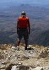
My truck rattled up Middlemarch Road and my mind waxed nostalgic thinking of previous Dragoon adventures and happier times. Parking along road 4393, I set off on foot for Black Diamond Peak, soon passing a group of hikers on their way down. The wind really picked up at the saddle, where I began the Henry Canyon traverse. The Black Diamond ridge line was just as fun as I remembered, despite the wind doing its best to blow me off of it. I quickly reached the summit, where I sat down to enjoy one of my most favorite summit views and to savor the whole Dragoon experience. I was surprised to find a nice note in the summit register for me that Angela had left a week earlier. Thank you, Angela! :) Not wanting to leave but knowing I had to, I began the hike back to my truck.

Arriving in Tombstone, I realized I wouldn't have enough time to hike Mount Ballard in Bisbee as my final hike of the day like I had planned, so I decided upon the Guindani Trail, another old favorite. Thick, puffy clouds were blowing over the Whetstones as I screeched to a halt at the Guindani trailhead. Sunset was only 20 minutes away. I moved quickly across the flats and into Guindani Canyon. It was well after sunset when I reached the saddle highpoint, where I stopped to admire the fascinating form of The Cape in the distance. Two miles later the trailhead came into sight under the light of my headlamp, where I happily escaped the wind inside my truck, before departing for Tucson.

I returned to Tucson in time for the last 60 seconds of the REI Garage Sale, ate a well earned dinner, than began the long journey home.

Although rushed, this was an outstanding and very memorable trip. :D
 Meteorology
 Meteorology [ checklist ]
[ checklist ]  Cumulonimbus
_____________________
"…you never know when a hike might break out" -Jim Gaffigan
 
Jan 25 2011
avatar

 Guides 4
 Photos 4,732
 Triplogs 2,607

55 male
 Joined Sep 29 2004
 Small Town USA
Guindani TrailTucson, AZ
Tucson, AZ
Hiking avatar Jan 25 2011
SkyIslander18Triplogs 2,607
Hiking8.10 Miles 1,730 AEG
Hiking8.10 Miles   3 Hrs   24 Mns   2.38 mph
1,730 ft AEG
 no routes
Partners none no partners
Figure 8 hike starting with the Guindani Trail and ending with the Foothills Loop. Guindani trail was better than expected and I really enjoyed all the views! Kicked up about 4-5 javalina in the canyon wash and had the poo scared out of me by a big covy of quail exploding out of the brush while climbing up to the saddle. Foothills loop was also nice (not quite as good as Guindani) and the views from the high point hill were also real good. Felt a little funny being at Kartchner Caverns just for a hike and not taking the cave tour.
 Culture
 Culture [ checklist ]
[ checklist ]  Mine Shaft  Windmill
_____________________
https://www.instagram.com/skyislander22/
 
Jan 23 2011
avatar

 Guides 1
 Routes 269
 Photos 613
 Triplogs 1,360

50 male
 Joined Dec 22 2003
 Tucson, AZ
Foothills Loop Trail - Kartchner CavernsTucson, AZ
Tucson, AZ
Hiking avatar Jan 23 2011
RedwallNHopsTriplogs 1,360
Hiking7.25 Miles 1,503 AEG
Hiking7.25 Miles
1,503 ft AEG
 no routesno photosets
1st trip
Linked   linked  
Partners partners
GrottoGirl
Figure 8 hike with a combination of the foothills loop trail and the Guindani trail.
_____________________
 
Jan 22 2011
avatar

 Guides 3
 Routes 569
 Photos 11,976
 Triplogs 1,634

50 female
 Joined Sep 18 2009
 Tucson, AZ
Foothills Loop Trail - Kartchner CavernsTucson, AZ
Tucson, AZ
Hiking avatar Jan 22 2011
GrottoGirlTriplogs 1,634
Hiking7.25 Miles 1,503 AEG
Hiking7.25 Miles   3 Hrs   35 Mns   2.02 mph
1,503 ft AEG
 
no photosets
Linked   linked  
Partners partners
RedwallNHops
Today was a special day! We did the Big Room at Kartchner with one of the discovers as our guide. Then he took us on a figure 8 hike: the Foothills Loop Trail and the Guindani Trail. We had never hiked in the Whetstones so it was nice to have Gary introduce us to an area that he spent a lot of time in. The Foothills Loop trail is an easy hike on a limestone hill. You can make your way to the top of the hill for an excellent view. There are tons of octillo and shindaggers on the hill - which is a great way to help figure out that there is limestone. The Guindani trail was actually a nice surprise. It heads up Guindani Canyon and then up over a ridge and looks down into Middle Canyon. The views are nice.
_____________________
  1 archive
average hiking speed 2.01 mph
1, 2  Next

WARNING! Hiking and outdoor related sports can be dangerous. Be responsible and prepare for the trip. Study the area you are entering and plan accordingly. Dress for the current and unexpected weather changes. Take plenty of water. Never go alone. Make an itinerary with your plan(s), route(s), destination(s) and expected return time. Give your itinerary to trusted family and/or friends.

helpcommentissue

end of page marker