|
| | | |
| |
|
| Hike & Climb | 4.30 Miles |
2,202 AEG |
| | Hike & Climb | 4.30 Miles | 4 Hrs 30 Mns | | 0.96 mph |
| 2,202 ft AEG | | | | |
|
|
| | |
| Partners |
|
[ show ]
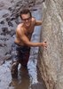
| partners | | Made a nice little loop today with Ken, Eric, and Richard. Up the South Face - we found the route to be pretty straight-forward and fun. The first move is indeed exposed, and after that, we zig-zagged our way up, generally following the path of least resistance. Well, except for Eric, who found a more, as he said, "exhilarating" route up. Ken, Richard, and I traversed over to find him after his detour, and we stayed on or near a minor ridgeline that met up with the main ridge. We found a couple minor climbs, including a chimney climb for Richard. We did not, however, encounter the chimney featured in the photos, which disappointed Richard. At least he got one in! The final bit was a steep hike and we were on the chilly summit.
Down the Southwest Ridge we went, and when we got to the saddle about halfway down, we made a beeline down the (brushy) drainage heading northwest toward the Dry Creek Road. The route went just fine, but wouldn't really recommend it unless you like thrashing around in thick brush with loose rock underfoot...
Looped back around to the car on the Lizard Head and Chimney Rock trails. |
| _____________________
| | |
|
|
|
 Route Editor