|
| | | |
| |
|
| Hiking | 5.83 Miles |
2,062 AEG |
| | Hiking | 5.83 Miles | 3 Hrs 14 Mns | | 1.80 mph |
| 2,062 ft AEG | | | | |
|
|
| |
| Partners |
|
none
[ show ]
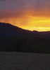
| no partners | | Snowy roads up north canceled my previous plans for the day, but there was no reason to sit inside on this fantastic day. With no real plan in mind, I headed for San Tan Regional Park. With my desire to avoid as many people as possible, I decided to access it from the west side, but when I got there, I was more intrigued by what I saw in the other direction. So off I went.
Peak 3010 has a summit register with about one visitor per year since 2006. One guy seems to do it a lot. But otherwise, not much. Apparently I'm not the first person to think this is the highest peak! Oh well.
I climbed down to the saddle and up to the real high-point. This mountain is very steep. The rain made it pretty soft, and not slippery scree, which was nice. 3104 has only a tiny pill bottle for a register but obviously had some attempted flagpole setup along with some geotrash. There was a single reference mark, but no benchmark, and no other reference mark. Somebody is on the hook for $250. 
Upon returning and looking this up on haz, it seems pretty clear that this peak is off limits. I crossed a handful of cattle fences along the way, but never saw any signs posted. But in retrospect, it seems like a good idea to get some kind of official permission before doing this. |
| _____________________
| I'm not sure what my spirit animal is, but I'm confident it has rabies. |
| | |
|
|
|
 Route Editor