|
| | | |
| |
|
| Hiking | 6.60 Miles |
3,284 AEG |
| | Hiking | 6.60 Miles | 5 Hrs | | 1.32 mph |
| 3,284 ft AEG | | | | |
|
|
| |
| Linked |
|
none
[ show ]
| no linked trail guides |
| Partners |
|
none
[ show ]
| no partners | | Note: AEG is for both Quartz peak and Butterfly Mountain (East). Distance is just for Quartz RT. See triplog for Butterfly for more info.
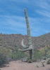
Brian and I met up with Dave and Haagen in the town of Maricopa around 9:15 am. We then drove West on Maricopa road and followed 91st Ave North from Maricopa road. We drove for a total of 14 miles making various turns according to the directions we found on HikeArizona.com. We arrived at the trailhead at around 10:30 am. At the trailhead, we found parking for about 10 cars along with restrooms. We started following an old mining road Northeast. We saw a sign-in registry within the first few minutes. After roughly 10 minutes the road ended and basically turned into a trail. The trail climbed up and reached the top of a ridgeline after traveling a total of 0.55 miles. From there, the trail basically followed a ridgeline, the rest of the way to Quartz peak. At times the trail dropped to the left or right of the ridgeline when the ridgeline got to be too rocky. When we got close to the peak, we could see that a large portion on the top was white colored quartz rock.
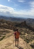
Brian and Haagen arrived at the summit about 15 minutes before Dave and myself. When we arrived we searched for a registry and did not find one. I happened to have a jar with me so I started a new registry and left it there. Two other hikers arrived when we were at the peak. A guy from Poland and another guy from Germany. They said they were in the Phoenix area on a business trip but didn't speak a lot of English.
From Quartz peak, we have some good views of South Mountain in PHX and of the Maricopa Mtns to the South. We also believe we could see Table Top Mtn which didn't look so flat from this angle. Lower down we could see Seven Mile Mountain which we also passed on the drive in.
We looked to the East and saw what we believed to be Butterfly peak. There was a West and East peak, we believed, and the ridgeline looked incredibly rocky. We talked it over and decided we would walk off trail in that direction to get a better look at that peak. After walking about 1/4 mile we were surprised at how fast our progress was and then realized we probably had time to summit and make it back to the main Quartz trail before it got dark. It was already 3 pm by this time. We spend a lot of time getting photos on the summit and chatting. Dave and Haagen decided to start their descent which Brian and I decided to get a closer look at Butterfly peak. As we came closer to Butterfly West, it looked like a rounded dome with steep cliffs all around. Good thing we didn't have to climb this one! From the side of Butterfly West, looking at Butterfly East, we both felt like we could climb it. We kept hiking around the rocky ridge, staying roughly 50 vertical feet below it. At times we found some good animal trails heading around and other times we didn't find anything. When we got close to Butterfly East, we noticed that it didn't look too difficult to climb. We climbed up from the West ridgeline and made it to the top. Up there we didn't find a registry so I left a new jar, starting a new registry. We figured that not too many hikers make it up to this peak. we got some quick photos from the top and then started to head back as we were a little concerned about the time.
It took us roughly 2 hours to get from Quartz peak to the top of Butterfly peak which was 1.2 miles of hiking for the us. Note that that straight-line distance between the 2 peaks was something like 0.7 miles. Going from Butterfly peak back to the Quartz peak trail only took us 1 hr and 20 mins. We made better choices on the route back and made it back to the trail well before dark around 6 pm. It got dark probably half way down and the hike down was quite slow going because of the rockiness. We kept moving taking only a few short breaks for water and ended up getting back to the trailhead around 8:30 pm.
Directions: I found a route on HikeArizona.com coming from the South off Maricopa road. See hikearizona.com for directions and info.
Timeline:
-----------
7:45 am - left Tucson area
9:15 am - arrived in town of Maricopa and met 2 other friends there, continuing on to the Quartz trailhead
10:30 am - arrived at Quartz trailhead
10:40 am - started down the trail
12:50 pm - Brian and Haagen summitted first (roughly 2 hrs 10 mins)
1:10 pm - Dave and myself summitted afterwards (roughly 2 hrs 30 mins). We didn't find a registry but I had a jar on me so I started a new registry. Surprisingly, two other hikers arrived while we were hanging out at the peak and signed it. We all looked at the rocky ridgeline heading toward Butterfly peak and talked ourselves out of it, at the time.
2:30 pm - Dave and Haagen left to head back down to the trailhead. Brian and myself decided to hike about 1/4 mile to check out Butterfly, thinking we most likely would not go all the way over there. We made such great progress that we started believing there was a chance we could actually make it there and get back to the Quartz trail before dark.
4:30 pm - after a final class 3 climb we made it to the top of Butterfly peak. We didn't find a registry but I had a 2nd jar on me so I started a new one (again). We got our pics and started heading back toward the Quartz trail, leaving the peak around 4:40 pm. We made better time on the way back. It took us 1 hr 20 mins to get back to the Quartz trail so our round trip time from Quartz to Butterfly and back was 3 hrs 20 mins. Haagen originally guessed 3 hours for the RT and his estimate was very good.
6:00 pm - back to rocky Quartz trail and starting to head down. It was still light at this time.
6:30 pm - We noticed a half+ moon which gave us some light and we really didn't need our lamps yet.
7:00 pm - it was getting darker. Brian took 1 fall but was OK. We both slipped a few times on rocky areas and prevented a fall but decided to turn our headlamps on so we could move a bit faster, even though we had good moonlight. When we could swear we had 1/2 mile left we still had something like 1.2 miles left which was frustrating. We really felt the rockiness on the way down and it never seemed to end until we got to the very bottom when we got to the road. The rockiness of the trail and perhaps the darkness definitely slowed us down.
8:30 pm - made it back to the trailhead, finally! Long day.
Stats (for both peaks):
---------------------------
Distance (round trip) = 8.98 miles
AEG = 3,284 feet
Strava moving time = 5 hrs 28 mins
Strava elapsed time = 9 hrs 54 mins |
| _____________________
Michael Williams
IT Professional
Rocky Point Vacation Rentals
Ocean Front Condo in Rocky Point, Sonora, Mexico
www.beachfrontmexico.us
 |
| | |
|
|
|
 Route Editor