username
X
password
register
for free!
help
ArticlesGuidesRoutes
 
Photosets
 
 Comments
triplogs   photosets   labels comments more
Frye Canyon Trail #36 - 6 members in 11 triplogs have rated this an average 3.8 ( 1 to 5 best )
11 triplogs
login for filter options
Nov 05 2022
avatar

 Routes 15
 Photos 128
 Triplogs 16

male
 Joined Mar 20 2022
 Safford, Arizona
Frye Canyon Trail #36Tucson, AZ
Tucson, AZ
Hiking avatar Nov 05 2022
RockinronnieFTriplogs 16
Hiking5.73 Miles 1,790 AEG
Hiking5.73 Miles   8 Hrs   5 Mns   1.11 mph
1,790 ft AEG   2 Hrs   55 Mns Break
 
1st trip
Linked   none no linked trail guides
Partners none no partners
Route Scout Route Recorded  on Route Scout | Pop | Map | Popup | MapDEX
How a popular well known Southern Arizona Trail can end mid mountain in an erased vanished tree and brush fallen state is beyond me. My 2 wheel drive jeep made it to the Frye Mesa Trailhead. I set out on a beautiful Fall Saturday at 8 AM. The mountain, the absolutely roaring stream, the fall colors did not disappoint!
You arrive at an old sign for Frye Trail at about 2 3/4 miles. See photos. You still have 1/4 mile to the Round the Mountain "T" -the end of Frye Canyon Trail. But the problem is there is no more trail. You look all around and you see nothing-except catclaw,and, scattered fallen trees. You've hit the multi Mount Graham wall. I bushwhacked to the spot where Frye C Trail hits RTM, but no cross trail was found. No trails at all were found. Wow, it would be a blessing if those who know how to restore trails did so for the special Round The Mountain, which I really like as it runs right into the heart of the mountain. Have any local hikers found the T connection and used it in either direction? Still a good 6 mile, 1800 elevation gain Saturday.
 Culture
 Culture [ checklist ]
[ checklist ]  Boiler
foliage observationfoliage observationfoliage observationfoliage observationfoliage observation
Autumn Foliage Observation Light
Many beautiful bright yellows,some reds, scattered snow after 6500 feet.
 
Apr 07 2022
avatar

 Guides 187
 Routes 989
 Photos 12,068
 Triplogs 864

72 male
 Joined Jun 27 2015
 Tucson, Arizona
Frye Canyon and Reservoir, AZ 
Frye Canyon and Reservoir, AZ
 
Hiking avatar Apr 07 2022
markthurman53Triplogs 864
Hiking6.80 Miles 1,864 AEG
Hiking6.80 Miles   5 Hrs   4 Mns   1.51 mph
1,864 ft AEG      33 Mns Break
 
1st trip
Linked   linked  
Partners partners
mamakatt22
We continued our second day of hiking in the Pinaleno Mountains on Frye Mesa. After Frye Mesa Reservoir we drove another half mile to the Frye Canyon Trail Head. The last .5 miles of the road is narrow but doable with a high clearance vehicle. Before hitting the trail we took a side trip to check out the upper falls. This is another spot I noticed last time I was here but didn’t have the time to check it out. I don't know how many falls are in this area but like the falls near the reservoir, without climbing equipment you can’t get very far up stream. We did manage to climb along the east side of the creek to get a better view of the falls. We then headed down stream to see how far we could go before hitting the upper part of the falls near the reservoir. We didn’t get to go too far before the creek bed drops away. I still want to check out the falls in Deadman Canyon that I didn’t have time to check out on a previous trip, Ginny and I will have to check Deadman Falls out on another trip to Safford; we won’t have time on this trip.

I did the Frye Canyon Trail a couple weeks ago and thought Ginny and I might do the lower portion of it on this hike. The last time this trail was almost nonexistent and took quite a bit of time to hike the 2.5 miles. This time it appears the trail crews have been in this area and now it is like a super highway. It looks like they may still be working the last .2 miles to the Round The Mountain Trail. This is a really nice hike with great scenery the whole way. Frye Creek was running pretty good but no issues crossing with the exception of a minor mishap when Ginny was crossing. She fell after stepping on an unstable rock, no injuries but some more bruises to add to her collection from the last 2 days.

Video [ youtube video ]
_____________________
  1 archive
Feb 26 2022
avatar

 Guides 187
 Routes 989
 Photos 12,068
 Triplogs 864

72 male
 Joined Jun 27 2015
 Tucson, Arizona
Frye Canyon Trail #36, AZ 
Frye Canyon Trail #36, AZ
 
Hiking avatar Feb 26 2022
markthurman53Triplogs 864
Hiking7.70 Miles 2,126 AEG
Hiking7.70 Miles   4 Hrs   39 Mns   1.89 mph
2,126 ft AEG      34 Mns Break
 
1st trip
Linked   linked  
Partners none no partners
On my second day in the Pinaleno Mountains I hiked the Fry Canyon Trail. My plan was to hike to the Round the Mountain Trail and head South to Deadman Ridge where I was suppose to go yesterday. Once again in reality I made it to the Round The Mountain Trail, or where it should be and returned. I started the Hike at Frye Mesa Reservoir. The drive up Frye Mesa is quite impressive. I was quite taken by the views of Mount Graham and the Mesa from along Frye Mesa Road. I parked at the reservoir because I was unsure of the road past that point. After walking the road it is quite doable with a high clearance vehicle and there is a good turn around point at the end of the road .7 miles past the reservoir. Great views of the falls of Frye Canyon at the end of the road.

The trail heads up a side canyon before crossing over into Frye Canyon. This trail follows an old road that use to head up to a saw mill in upper frye canyon. The trail is easy to follow the first 2.5 miles then becomes very faint. There were pink ribbons marking the trail so this made it quite a bit easier, still a lot of overgrowth though. A few rock cairns also mark the trail. The ribbons take you to a point just below where the Round The Mountain Trail should be. At the end of the trail is an old sign marking the Frye Canyon Trail indicating Fry Mesa Reservoir 3 miles, nothing else on the sign. I would imagine the Round The Mountain Trail should be at this point but it wasn’t. There was an old boiler and remnants of some equipment used by the sawmill that was at this location. There was also a metal box for storage probably used by the Inception Ranger Station that was also located in this area. My GPS Routes showed the Fryes Canyon Trail heading further uphill to meet the Round The Mountain Trail so I headed up to where it should be. Never found any trace of the Trails, beginning to think this Round the Mountain Trail is just a phantom trail now. When I was hiking the upper end of this trail from up on top of the mountain a couple years back I had the same experience, no trail could be found. Does anyone have any information on the condition of the northern end of this trail?

Really nice hike in a scenic canyon; looks like there is a lot to explore along the lower creek just above Frye Mesa Reservoir. To make this hike a little shorter I would recommend taking the road further up to where it ends instead of starting at the reservoir. A vehicle with a bit of high clearance should not have an issue. I’m a little embarrassed that I have a jeep and didn’t drive this last portion, but then I love walking along rocky dirt roads, plenty of time to be in your head, which can sometimes be a scary place or have some stupid song stuck on replay over and over. Fry Creek had a good flow but not enough to hinder crossing.
 Culture
 Culture [ checklist ]
[ checklist ]  Boiler
_____________________
 
Dec 13 2021
avatar

 Guides 4
 Photos 4,732
 Triplogs 2,605

55 male
 Joined Sep 29 2004
 Small Town USA
Frye Mesa ReservoirTucson, AZ
Tucson, AZ
Hiking avatar Dec 13 2021
SkyIslander18Triplogs 2,605
Hiking3.00 Miles 520 AEG
Hiking3.00 Miles
520 ft AEG
 no routes
Partners partners
AddSanz
Day trip with my buddy up to Frye Mesa/Canyon & Reservoir.
First the awesome drive up and across the mesa.
Then a hike down to the lake and around back to the big waterfall.
Also sat for a little fishing, skunked.
Then just a bit up Frye Canyon and a hike down to the bottom of S'mores Canyon or as I grew up calling it ... The Potholes.
Lots of very cool waterfalls into waterfalls here.
Then back down ending a good day with a great friend!
:D
foliage observationfoliage observationfoliage observationfoliage observationfoliage observation
Autumn Foliage Observation Moderate
Some nice colors along the lake shore.

water 1 out of 5water 2 out of 5water 3 out of 5water less than max Frye Canyon Medium flow Medium flow

water 1 out of 5water 2 out of 5water 3 out of 5water 4 out of 5 Frye Mesa Reservoir 76-100% full 76-100% full
_____________________
https://www.instagram.com/skyislander22/
 
Mar 21 2021
avatar

 Guides 94
 Routes 840
 Photos 22,055
 Triplogs 1,993

52 male
 Joined Sep 18 2002
 Tempe, AZ
Frye Canyon Trail #36Tucson, AZ
Tucson, AZ
Hiking avatar Mar 21 2021
chumleyTriplogs 1,993
Hiking1.87 Miles 765 AEG
Hiking1.87 Miles   1 Hour   24 Mns   1.39 mph
765 ft AEG      3 Mns Break
 no routes
1st trip
Partners none no partners
It's floatie season, so I figured this one would give me the opportunity to take an occasional dip along the trail. Cliffed out above the reservoir and opted to drive to the official trailhead. Fun road! :D

Not sure when the old road/trail was washed out (seemed older than Nuttall Gibson?) but the bypass option was unpleasantly steep lol. Took the old trail on the way down and was forced to do a little climb to get through the washout.

Higher up, dropped into the creek and explored down as far as I felt comfortable. Nice views of lingering snow higher up.

Back at the truck, I headed over into the mid section to explore a bit. There's some crazy old webbing and U-channel post anchors that illustrate stupidity isn't just a modern thing.

Cool area though. I'd actually like to take the trail up and loop Trap or head all the way up to camp.
_____________________
I'm not sure what my spirit animal is, but I'm confident it has rabies.
 
Nov 25 2015
avatar

 Guides 4
 Photos 4,732
 Triplogs 2,605

55 male
 Joined Sep 29 2004
 Small Town USA
Frye Canyon Trail #36Tucson, AZ
Tucson, AZ
Hiking avatar Nov 25 2015
SkyIslander18Triplogs 2,605
Hiking7.85 Miles 2,127 AEG
Hiking7.85 Miles
2,127 ft AEG
 no routesno photosets
Linked   linked  
Partners partners
Abqkathy
weavejd
Started the morning with a drive down to the reservoir and hike to the backside waterfall that feeds the lake.
Then drove back up and on to the Frye Canyon TH.

This was my 2nd hike up Frye Canyon this year.
1st trip was last January with the trail covered in snow, it was tough!
This trip the trail was snow free and I think just as tough!
The upper peaks were covered with snow and the creek was flowing good from the melt.
All three of us (and my partner's dog) ended up in the creek at least once from the challenging above average creek flow crossings.
Autumn is just about done up this canyon, but there were still some good colors to see here & there.
1st half of the trail was in really good shape and looked to have been FS worked this year.
2nd half needs some work, but still decent to follow.
All in all a beautiful canyon hike up to the Inception/Round the Mountain T.
Mountain was overcast most of the day and it rained on us a bit up high.
Nice canyon, good friends & a fun time on the north side!
foliage observationfoliage observationfoliage observationfoliage observationfoliage observation
Autumn Foliage Observation Light
wildflower observationwildflower observationwildflower observationwildflower observationwildflower observation
Wildflowers Observation Isolated

water 1 out of 5water 2 out of 5water 3 out of 5water less than max Frye Canyon Medium flow Medium flow

water 1 out of 5water 2 out of 5water 3 out of 5water 4 out of 5 Frye Mesa Reservoir 76-100% full 76-100% full
_____________________
https://www.instagram.com/skyislander22/
 
Sep 15 2015
avatar

 Guides 7
 Routes 72
 Photos 14,456
 Triplogs 627

62 female
 Joined Aug 19 2011
 Scottsdale, AZ
Frye Creek Canyon - S'moresTucson, AZ
Tucson, AZ
Canyoneering avatar Sep 15 2015
outdoor_loverTriplogs 627
Canyoneering1.53 Miles 310 AEG
Canyoneering1.53 Miles
310 ft AEG
Intermediate Canyoneering - Difficult or dangerous; Tech Climb; rope reqd; descent anchor; exit technical;
C - Strong current; wading/swimming; waterfalls; possible wet/dry suit
II - Normally requires a half day
 no routes
1st trip
Partners none no partners
This Canyon has been on the List for awhile now...Once I really got my Feet Wet in Ouray, I knew I could do this Canyon so when a FB Friend threw out an Invite, I was in.... :y:

We did it as a Day Trip and took 2 Vehicles for a Shuttle. I thought that might have been Excessive, but by the Time we got back to the Vehicles, I was glad he did it that way... :sweat:

Early Start, got down there, got the Vehicles in place and started Hiking...I had a few Nerves on this Trip. I knew the Slickrock in this Canyon was a big Issue as far as Traction goes, I was going with 4 Guys that I had just met and I only knew the Experience of 1 of them. And we were all doing this Canyon for the 1st Time. :sweat: It turned out Fine with 1 small Exception...Oops... :o

We dropped in and followed the Creek down...No Slipping involved for most of us, but the Rappelling and the Sliding was sure a Blast...What an Awesome Canyon this was. Exceeded my Expectations and more...So Glad I got to do this one... :y:

Over 3/4 of the Way Down and I came to what looked like a Good Slide. One of the Guys had gone down before me, so when I asked about the Slide being Ok, he stated that it was...He must have somehow avoided what I hit. At the Bottom of the Slide, on the Slide itself, there must have some kind of Rock Outcropping under the Water and I hit it with my Left Heel with my Knee locked. I went from 20 MPH to a Dead Stop instantly and the Concussion and Compression traveled all the way up my Left Side almost to my Neck. Apparently one of my Ribs decided that the Buck should stop there and I felt something go... :( Was pretty sure something broke, but I didn't get it Confirmed until 2 Weeks later...(Today) I was Lucky and hadn't Punctured a Lung though, so that was Good. It hurt like Hell to Breathe, but at least I could Breathe. After the Initial Shock and Pain went away and everyone else had Downclimbed the Slide, we continued on, with me being a lot more Uncomfortable, but still under my Own Power. I was now quite a bit Slower as well. Rappelling wasn't too bad, but everything else was troublesome and I got Winded really easily due to Breathing much Shallower. ;) But...we made it down with just that 1 Incident and I was still Walking and Talking...And apparently Swimming. The Guys decided to try to Downclimb to the Dam and walk over on the Dam to the Vehicle. I looked at how Narrow the Top of the Dam was and said No Thanks and swam the Reservoir back to the Car. I ended up beating them all back there... :lol: After we Retrieved the other Vehicle, we hit the Road for Phoenix, tired but glad we saw and did such a Sweet Canyon...By the Time I got back to my Vehicle in Mesa, I had to basically fall out of Philip's SUV, I had gotten so stiff and sore. The Rib was getting seriously Painful and it was hard to Move at all. I didn't have Time for an Injury though, I was leaving for Zion the next Day... :sweat: (Details in Future Triplogs)

Great Canyon with Good People...Met some New Friends and had a Blast, even with the "Hiccup"....This Canyon will be an Annual One for me, it's that Good. Hope to do it just a Tad better the next Time around though... :sweat: I am now on "Light Duty" for at least another 8 Weeks...No Canyons, No Backpacking and probably nothing more than very Light Hikes where I don't have to carry much of a Pack...Time for some "Strictly Photography" Trips I guess... :) I feel extremely Lucky to have Escaped that little Incident with just 1 Rib...I should have Broken my Leg...Better to be out for Time, than for Surgery with Pins and Plates, and then Time.... :o

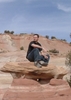
Photos...Quite a Few this Time. These Class C Canyons really make for some very Photogenic Rappelling Scenes and it's one of the Few Times I actually enjoy Photographing People... :D

Videos...There are 3...The First 2 are a slightly Sketchy Slide that we did. You hit your Tailbone a bit, but you're going so Fast that it's a glancing Blow... :lol: The 3rd is my Failure to Videotape myself doing a Slide that involved Potholes with Hydraulics...I've Fallen in a Hole and I can't get out.... :lol:

https://youtube.com ... 0uFA

https://youtube.com ... PYxk

https://youtube.com ... HKUs
 Flora
 Flora [ checklist ]
[ checklist ]  Cardinalflower
wildflower observationwildflower observationwildflower observationwildflower observationwildflower observation
Wildflowers Observation Isolated

water 1 out of 5water 2 out of 5water 3 out of 5water less than max Frye Canyon Medium flow Medium flow

water 1 out of 5water 2 out of 5water 3 out of 5water 4 out of 5 Frye Mesa Reservoir 76-100% full 76-100% full
_____________________
Life is not a journey to the grave with the intention of arriving safely in a pretty & well preserved body, but rather to skid in broadside, totally worn out & proclaiming, "Wow What a Ride!"
  1 archive
Jan 06 2015
avatar

 Guides 4
 Photos 4,732
 Triplogs 2,605

55 male
 Joined Sep 29 2004
 Small Town USA
Frye Canyon Trail #36Tucson, AZ
Tucson, AZ
Hiking avatar Jan 06 2015
SkyIslander18Triplogs 2,605
Hiking9.10 Miles 2,230 AEG
Hiking9.10 Miles
2,230 ft AEG
 no routesno photosets
Linked   none no linked trail guides
Partners partners
AddSanz
Mine & Addie's regular Tuesday hike.
First time for the both of us on this trail.
I figured we would hit snow up high, but we hit it right from the start so I'm calling this our first snow hike of the year!
Challenging, time consuming & exhausting trail to follow covered in snow, but after taking our time we managed to complete the entire route up to Inception/Round the Mountain T ..... Hell Ya!!!
Found the old sawmill site (I believe) and spent some time poking around the old artifacts before heading back down in a race to beat sunset.
No wildlife spotted today, but tons of snow prints including bobcat, coatimundi, deer & bear.
Highlight for me was a couple of big frozen waterfalls across the canyon and the good flow of Frye Creek that we followed for most of the hike.
Thanks Miss Addie for pushing me on this one, another good time on ole Graham !!!

water 1 out of 5water 2 out of 5water 3 out of 5water less than max Frye Canyon Medium flow Medium flow

water 1 out of 5water 2 out of 5water 3 out of 5water 4 out of 5 Frye Mesa Reservoir 76-100% full 76-100% full
_____________________
https://www.instagram.com/skyislander22/
 
Feb 13 2011
avatar

 Guides 170
 Routes 148
 Photos 5,914
 Triplogs 2,097

48 male
 Joined Apr 12 2004
 Tucson, AZ
Frye Canyon Trail #36Tucson, AZ
Tucson, AZ
Hiking avatar Feb 13 2011
PrestonSandsTriplogs 2,097
Hiking5.70 Miles 1,850 AEG
Hiking5.70 Miles
1,850 ft AEG
 
Linked   none no linked trail guides
Partners none no partners
With nothing better to do, I figured I should waste my afternoon in good old Frye Canyon. Up Frye Mesa I went, punishing my truck with God-awful rocks and washboards galore. Speeding like a madman helped slightly with the bumps. I parked near the lake and continued on foot. Along the way, I met another hiker :o in Spring Canyon, who inquired about the trail.

Once in the bottom of Frye Canyon itself, I was pleasantly surprised to see...trail maintenance!!! :y: Someone had cut many of the logs that had fallen across the trail after the Gibson Fire. Inspired, I began marking and cairning, and slowly worked my way up Frye Creek. The sounds of rushing water filled the canyon and the air was chilly. Interesting sights along the way included a frozen waterfall with numerous icicles hanging down, tracks of some large human-like creature made larger by the melting of the snow, old rock walls, and, of course, the rugged snow covered cliffs of Trap Peak high above.

With the hour growing late, I ended my casual hike just over a half mile below the Round The Mountain Trail junction, and focused on getting an accurate gps track of the trail to that point. Dusk faded into moonlight on the way down, and distant city lights appeared. After a fun adventure, I began the drive down. Even in first gear, the road was hell. I came to the conclusion that my front shocks had blown out at some point on the drive. ](*,) 'Twas a fun day in a beautiful canyon.

https://www.youtube.com/user/PrestonTheY ... WSX2AZ_DYc
_____________________
"…you never know when a hike might break out" -Jim Gaffigan
 
Mar 24 2009
avatar

 Photos 35
 Triplogs 23

48 male
 Joined Mar 29 2006
 Scottsdale, AZ
Frye Canyon Trail #36Tucson, AZ
Tucson, AZ
Hiking avatar Mar 24 2009
DesertRatW3Triplogs 23
Hiking6.80 Miles 2,143 AEG
Hiking6.80 Miles
2,143 ft AEG
 no routesno photosets
1st trip
Linked   none no linked trail guides
Partners none no partners
_____________________
 
Mar 05 2007
avatar

 Guides 170
 Routes 148
 Photos 5,914
 Triplogs 2,097

48 male
 Joined Apr 12 2004
 Tucson, AZ
Frye Canyon Trail #36Tucson, AZ
Tucson, AZ
Hiking avatar Mar 05 2007
PrestonSandsTriplogs 2,097
Hiking6.50 Miles 2,143 AEG
Hiking6.50 Miles   4 Hrs      1.63 mph
2,143 ft AEG
 
Linked   none no linked trail guides
Partners none no partners
This was a convince-the-boss-into-getting-off-early hike. Even so, I got a late start, and ended up turning around near the end when it got too dark to see anymore. It was a long hike back with lots of stumbling in the dark. Apparently this trail does not see much use (or maintenence :wink: ). Even with the wildfire damage, this is still a cool area to explore. I loved the waterfalls-that was an unexpected treat! This trail would probably be one of the quicker ways to access the top of the Pinalenos from the deserts below. Good times! :D
_____________________
"…you never know when a hike might break out" -Jim Gaffigan
 
average hiking speed 1.5 mph

WARNING! Hiking and outdoor related sports can be dangerous. Be responsible and prepare for the trip. Study the area you are entering and plan accordingly. Dress for the current and unexpected weather changes. Take plenty of water. Never go alone. Make an itinerary with your plan(s), route(s), destination(s) and expected return time. Give your itinerary to trusted family and/or friends.

helpcommentissue

end of page marker