username
X
password
register
for free!
help
ArticlesGuidesRoutes
 
Photosets
 
 Comments
triplogs   photosets   labels comments more
13 triplogs
login for filter options
Nov 27 2015
avatar

 Photos 111
 Triplogs 13

79 male
 Joined Jan 01 2010
 Whiteriver, AZ
Camelback Mountain - TH to TH and Back, AZ 
Camelback Mountain - TH to TH and Back, AZ
 
Hiking avatar Nov 27 2015
hikerguyTriplogs 13
Hiking5.00 Miles 2,725 AEG
Hiking5.00 Miles   3 Hrs   40 Mns   1.76 mph
2,725 ft AEG      50 Mns Break8 LBS Pack
 no routesno photosets
1st trip
Partners none no partners
Having not done a decent hike in a couple years I decided to hike from the Cholla TH to the Echo Canyon TH and then get back to my truck by reversing my route rather than flatlanding it back. I left the Cholla TH at noon with temp around 60. I don't think the temp ever got past the mid 60s so it was a perfect day for a strenuous hike. By the time I got to the Echo Canyon TH I was wondering if my old legs had it in them to go back up and over. But I decided to take my time on the return and found it to be easier than I thought it would be. I have never seen more people on any trail I've ever hiked. When I got to the summit a little before 1PM, I saw it was pretty much standing room only up there. When I got to the summit the second time a little over an hour later it wasn't quite so crowded. But what a beautiful day for a hike!

P.S. Not sure about linking the two trail descriptions as I did because obviously that's not the correct order of the segments. Actual hike would be described as follows: Cholla trail to summit, down Echo Canyon trail, Echo Canyon trail to summit, and down Cholla trail. Not included in the hike distance is the walk from and to my truck which was more than a mile from the Cholla TH.
_____________________
 
Nov 29 2014
avatar

 Photos 111
 Triplogs 13

79 male
 Joined Jan 01 2010
 Whiteriver, AZ
Miners Needle LoopPhoenix, AZ
Phoenix, AZ
Hiking avatar Nov 29 2014
hikerguyTriplogs 13
Hiking9.00 Miles 1,750 AEG
Hiking9.00 Miles   4 Hrs   13 Mns   2.37 mph
1,750 ft AEG      25 Mns Break8 LBS Pack
 no routes
1st trip
Linked   none no linked trail guides
Partners none no partners
This was my first time hiking this particular loop. Trail was in good shape, all trail signs were in place, a few cairns in strategic places helped with route finding. Overall the loop route is very easy to follow.

The eye of Miners Needle is visible from several directions. The Weavers Needle shows up at several points along the route, too. There were some very impressive vistas.
_____________________
 
Apr 01 2013
avatar

 Photos 111
 Triplogs 13

79 male
 Joined Jan 01 2010
 Whiteriver, AZ
Superstition RidgelinePhoenix, AZ
Phoenix, AZ
Hiking avatar Apr 01 2013
hikerguyTriplogs 13
Hiking11.60 Miles 5,462 AEG
Hiking11.60 Miles   9 Hrs   15 Mns   1.50 mph
5,462 ft AEG   1 Hour   30 Mns Break12 LBS Pack
 no routes
1st trip
Linked   none no linked trail guides
Partners none no partners
Six days prior to this hike I had tried to reach the summit of Peak 5057 from the Carney Springs trailhead, but had walked past the summit without finding the route up. I was a little bummed about that so I convinced my friend, Dave, to hike the Superstition Ridgeline with me so I could accomplish three goals - reaching that summit, introducing him to Superstition hiking, and hiking the ridgeline.

We started at 7:00am from the Carney Springs trailhead on Peralta Road and followed the usual route to the ridgeline. This time, with the help of Dave's GPS app on his cell phone and a somewhat better topo map, we found and conquered the summit of Peak 5057 with no difficulty in about 2 hours 45 minutes. It didn't seem possible to leave the summit on the north side (too steep) so we backtracked to below the hoodoos and picked up the ridgeline trail from there. By the way, it's about time to put another notepad in the ammo box at the summit. Not much room to add new entries on the existing pads!

The ridgeline trail is certainly a challenge from an endurance standpoint due to all the elevation changes, especially after the effort of getting up there from either end. However, route-finding is not really an issue because rock cairns do a decent job of keeping you on course. The views in all directions are outstanding. One can only imagine how beautiful they were before Valley pollution existed.

It took exactly four hours for us to trek from the summit of Peak 5057 to the end of Flatiron and that included a half hour break for lunch and a few other breaks along the way.

After making the descent down Siphon Draw trail, Dave said if we had started from that end, he would never have continued with the ridgeline trail! By the way, we finished our hike at the Siphon Draw trailhead in Lost Dutchman State Park at 4:15pm.

The AEG given for the official description of this hike (4480 feet) is very different from what Dave's GPS route indicated for our hike. Our hike shows a total elevation gain of 5462 feet. I don't know why there is such a discrepancy. Climbing Peak 5057 shouldn't make that much difference. Also, our hike shows a total elevation loss of 5582 feet, which makes sense because Lost Dutchman State Park is about 120 feet lower elevation than the Carney Springs trailhead.

Other than the pain of all that climbing and the sore toes (from being crushed into the ends of our shoes on the Siphon Draw descent), it was a good experience. However, Dave says he prefers the forest trails in the White Mountains to the desert trails in the Superstitions. I think we're still friends.

The temperature was probably in the 60s and 70s for most of the hike. Along the ridgeline there was a very nice breeze that felt SOOOO GOOD! As we descended Siphon Draw the temperature got into the low 80s. We each started with about 5 quarts of water. There wasn't much of that left by the time we finished the hike.
 Culture
 Culture [ checklist ]
[ checklist ]  Benchmark
wildflower observationwildflower observationwildflower observationwildflower observationwildflower observation
Wildflowers Observation Moderate
_____________________
 
Mar 26 2013
avatar

 Photos 111
 Triplogs 13

79 male
 Joined Jan 01 2010
 Whiteriver, AZ
Superstition Peak 5057 - CarneyPhoenix, AZ
Phoenix, AZ
Hiking avatar Mar 26 2013
hikerguyTriplogs 13
Hiking9.10 Miles 3,268 AEG
Hiking9.10 Miles   6 Hrs      1.92 mph
3,268 ft AEG   1 Hour   15 Mns Break7 LBS Pack
 no routes
1st trip
Linked   none no linked trail guides
Partners none no partners
This hike is in the Superstition Mountains. I started from the small parking area at the Carney Springs trailhead on Peralta Road and intended to hike to the summit of Peak 5057. The trail was easy to follow. Some portions of the trail had plenty of rock cairns to assist with navigation.

I found the trail to be brutal up to the saddle just before turning west to head over to Peak 5057. Beyond the saddle, there were a few relatively flat sections for a little respite.

I did not have a trail GPS unit so I took the GPS that usually resides in my truck so that I could at least get a Lat/Long at the farthest point I reached. Otherwise, it isn't really much good for the trail.

I thought the trail I was on would take me right to the summit of Peak 5057, but it didn't. Perhaps there was a fork that I missed as I approached the summit. In any case, I ended up just past the peak and couldn't tell where it was. So I sat down and ate my lunch and headed back to the trailhead.

I did record the Lat/Long at the point I reached. When I got home I used Google Earth to see where I ended up in relation to the summit. I had walked slightly past the summit and was about 140 feet below it. Oh well, my legs didn't really want to do any more climbing anyway.

I will be paying for this trek tomorrow. Guess I better dig out the Advil NOW!
wildflower observationwildflower observationwildflower observationwildflower observationwildflower observation
Wildflowers Observation Moderate
Heaviest concentrations were at lower elevations about a mile in from the trailhead.
_____________________
 
Nov 25 2011
avatar

 Photos 111
 Triplogs 13

79 male
 Joined Jan 01 2010
 Whiteriver, AZ
Thompson Peak from Dixie Mine THPhoenix, AZ
Phoenix, AZ
Hiking avatar Nov 25 2011
hikerguyTriplogs 13
Hiking9.50 Miles 2,250 AEG
Hiking9.50 Miles   3 Hrs   35 Mns   3.17 mph
2,250 ft AEG      35 Mns Break3 LBS Pack
 no routesno photosets
1st trip
Linked   linked  
Partners none no partners
Whoever built the road up to the summit failed Mountain Road Construction 101. The rule of thumb is switchbacks with gravel, not straight up with concrete! Grit and gravel on top of the concrete in a few places caused me concern that my feet would slip right out from under me.

The polluted valley air made seeing the Superstitions and almost everything else pretty much impossible.

Oh well, it was a good workout.

By the way, the trail fee is now $2.00.
_____________________
  1 archive
Oct 30 2011
avatar

 Photos 111
 Triplogs 13

79 male
 Joined Jan 01 2010
 Whiteriver, AZ
Red Rock, AZ 
Red Rock, AZ
 
Hiking avatar Oct 30 2011
hikerguyTriplogs 13
Hiking1.16 Miles 286 AEG
Hiking1.16 Miles      40 Mns   2.78 mph
286 ft AEG      15 Mns Break1 LBS Pack
 no routes
Linked   none no linked trail guides
Partners none no partners
Met Darrell and Helen D. at the top of Red Rock this afternoon. Darrell took my picture up there.
_____________________
 
Oct 23 2011
avatar

 Photos 111
 Triplogs 13

79 male
 Joined Jan 01 2010
 Whiteriver, AZ
Red Rock, AZ 
Red Rock, AZ
 
Hiking avatar Oct 23 2011
hikerguyTriplogs 13
Hiking1.02 Miles 326 AEG
Hiking1.02 Miles   1 Hour   25 Mns   0.87 mph
326 ft AEG      15 Mns Break1 LBS Pack
 no routes
Linked   none no linked trail guides
Partners none no partners
This was a beautiful day to go for a short climb up the hill behind the Mission. Temperature about 81 deg.
_____________________
  2 archives
Oct 10 2011
avatar

 Photos 111
 Triplogs 13

79 male
 Joined Jan 01 2010
 Whiteriver, AZ
Mount Baldy LoopAlpine, AZ
Alpine, AZ
Hiking avatar Oct 10 2011
hikerguyTriplogs 13
Hiking17.00 Miles 2,880 AEG
Hiking17.00 Miles   8 Hrs   35 Mns   2.24 mph
2,880 ft AEG   1 Hour    Break5 LBS Pack
 no routes
1st trip
Linked   none no linked trail guides
Partners none no partners
Our hike to the north peak of Mount Baldy (the main peak is on reservation land and is off limits to non-Apache hikers) actually began at Sheep Crossing which made the total distance about 18 miles (according to our gps unit) instead of the 17 miles given for this loop. We hiked the loop in a counter-clockwise direction. The temperature at the start was about 32 deg F. The weather was ideal, sunny and cool. Matt, Dave, and I were accompanied by Dave's dog, Jesse. Jesse enjoyed the trek as much as we humans. Maybe more, because she seemed almost ready to do the loop again even though the humans were dead tired by the end.

The hike started out on dry ground, but by the time we reached the 10,000 ft elevation, snow and ice were present due to the first significant snow of the season that had fallen a few days earlier. Snow depth was never more than 5 or 6 inches and the footing was decent. I was tempted to put on my crampons a few times but never did.

On the way up, we passed through a patch of dead forest that had apparently been stricken by the bark beetle. I hope this doesn't become too commonplace in the White Mountains. It sure takes away from the beauty of the area.

The ascent route along West Baldy Trail #94 is mostly through dense forest - mainly spruce and a little aspen. Long range views are few. We were in deep shade most of the time. That explained why we spent so much time walking on snow.

The summit of Mt. Baldy is mostly barren (probably due to the lack of soil and being windswept) so one has a good 360 deg view. According to one of my hiking buddies you can see Mt. Humphreys on a clear day. Apparently it wasn't clear enough this particular day because I couldn't see it. We were able to make out part of the area burned by the Wallow wildfire a few months prior. Fortunately, the fire did not touch any part of this hiking loop.

The descent route along East Baldy Trail #95 eventually opens up in the area of some beautiful rock formations providing great views to the South overlooking a valley and the opposing ridge. The aspen on that ridge were mingled with the spruce which accentuated the Fall colors of the aspen. It was breathtaking.

To get back to the parking area at Sheep Crossing, we took the crossover trail that completes the loop. By this point my legs were about ready to fall off (thanks to this being the longest hike I had ever done!) so the ups and downs of this part of the hike were almost more than my old body was willing to do. But we successfully completed the loop and felt a deep sense of satisfaction. This day hike was well worth the effort!
 Culture
 Culture [ checklist ]
[ checklist ]  Airplane Wreckage
_____________________
 
Nov 26 2010
avatar

 Photos 111
 Triplogs 13

79 male
 Joined Jan 01 2010
 Whiteriver, AZ
Wind Cave from McKellips-Crismon TH, AZ 
Wind Cave from McKellips-Crismon TH, AZ
 
Hiking avatar Nov 26 2010
hikerguyTriplogs 13
Hiking7.70 Miles 1,000 AEG
Hiking7.70 Miles   2 Hrs   34 Mns   3.00 mph
1,000 ft AEG
 no routesno photosets
1st trip
Linked   none no linked trail guides
Partners none no partners
Great exercise. Honeybees were busy at seeps in the cave.
_____________________
 
Jan 08 2010
avatar

 Photos 111
 Triplogs 13

79 male
 Joined Jan 01 2010
 Whiteriver, AZ
Queen Creek Canyon- Pond Section, AZ 
Queen Creek Canyon- Pond Section, AZ
 
Climbing avatar Jan 08 2010
hikerguyTriplogs 13
Climbing2.00 Miles 400 AEG
Climbing2.00 Miles   2 Hrs   25 Mns   0.83 mph
400 ft AEG
Sport climbing G  • Sport • 5.4 Volcanic Excellent • 30 Feet 
 no routes
1st trip
Linked   none no linked trail guides
Partners none no partners
Friends and I drove to Queen Creek Canyon to do some climbing there. Well, my friends planned to do some climbing and I was just going to hike around the area and then watch them for a while.

To access the Pond climbing area, leave your vehicle in the parking area that is about 0.6 mile east of the Queen Creek tunnel on US60. Walk east along the side of the road to a short bridge. Walk under the bridge to the opposite (North) side of the road. Climb along the right side of the wash a short distance until you come to a pond (sometimes dry). If it has water in it and you want to keep your feet dry, it's a little tricky to get around it to access the paths to the climbing area. Assuming you want dry feet, you can climb over the rocks to the right of the pond or you can climb across the wall for about ten feet. You'll find three handholds on the wall. Once you get past the pond, you can use several anchored rebar rungs and a short rope to get up to the trails that take you to the climbing area. Then just follow the trails. There are many climbing routes of varying degrees of difficulty in this section. It would be good to obtain a climbing guide for the area.

After hiking up to the top of the hills above where my friends were climbing and taking a few pictures, I decided to go down to watch them climb. It was way too windy up top. Unfortunately, the route down was not obvious. After 45 minutes of trying to find the route by which I came up, I was beginning to think it was about time to call in a helicopter to rescue me. Finally, after pushing my way past a bush, I saw the top of my route down. Makes me want to invest in a handheld GPS unit.

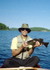
I rejoined my friends and enjoyed their escapades on the rock face. Two of them had some experience with sport climbing. The rest of us had never done this sort of thing before, although one had done a lot of rappeling in his work for the fire department. Eventually, Matt suggested that I give it try. At first, I declined, but eventually I said, well ok, maybe the first 10 feet.

Once I got on that rock face, well protected by the belay line as I was and the fact that one might call this rock face a "bunny slope", well, I just kept going. What a thrill it was to touch the chains at the top and look down and all around! Matt controlled my descent with the belay line and my first climbing experience was a success. Needless to say, I hope that won't be my last climb!

The distance and AEG values are just estimates determined by using Google Earth (Sorry, no GPS device). The 5.4 difficulty rating given above is what my more experienced friends said the route we were climbing was rated, but I don't know how they got that number. As I said above, this "bunny slope" was probably the easiest route in the area.
_____________________
 
Jan 02 2010
avatar

 Photos 111
 Triplogs 13

79 male
 Joined Jan 01 2010
 Whiteriver, AZ
Superstition Peak 5024 - Siphon DrawPhoenix, AZ
Phoenix, AZ
Hiking avatar Jan 02 2010
hikerguyTriplogs 13
Hiking5.84 Miles 2,898 AEG
Hiking5.84 Miles   4 Hrs   45 Mns   1.23 mph
2,898 ft AEG
 no routes
1st trip
Linked   none no linked trail guides
Partners none no partners
I left the Siphon Draw trailhead at Lost Dutchman State Park at 8:10 this beautiful January morning. I had a lot of good eating during the past week to work off. Besides, I had never been on this trail before and the trip descriptions I had found in various places all made it sound like a great last hike for this particular trip to Arizona.

It didn't seem like a very popular trail judging by the few cars in the parking area and the few hikers on the trail compared to other hikes I had made in the Phoenix area. It crossed my mind that maybe this trek up Siphon Draw was more of a challenge than I was ready for. But after the first mile or so (the warmup) I found I was more than ready to tackle the steeper portions as I neared the saddle between the peak to the northeast and Flatiron to the southwest.

To my surprise, exactly two hours after leaving my truck, I had Flatiron to myself at 10:10 AM. How was it possible that this awesome destination was deserted? I have to confess that as I was climbing up through the Draw, a descender I talked to said he had camped overnight on Flatiron. By the time I had eaten a snack and shared some of it with a little beggar (a chipmunk) and his compatriot (a small bird), the crowds began to arrive. By the time I was ready to head over to and climb the nearby summit, about twenty hikers had joined me on Flatiron. Eventually, the expected crowds arrived and continued to arrive as I noted on my descent later on.

The climb from the saddle to the summit of Peak 5024 was surprisingly easy. From the saddle it had looked to be impossible, but it took only about 15 minutes. The first thing I saw from the summit was Weaver's Needle due East, which I had stood at the base of only a month earlier while on the Peralta Trail. Somehow it had looked much more imposing from the Peralta Trail and from Fremont Saddle. The summit also provided a view of a couple of lakes to the North and a fabulous view of Flatiron.

The descent was brutal on my quads and knees. As I always say, the ascent destroys the lungs, the descent the quads. But the experience was so worth the pain! I arrived at my truck at 12:55 PM.

I would classify this hike as the most difficult I have attempted. Still on my agenda before I get too old to do it: the Superstition Ridgeline.
_____________________
 
Nov 27 2009
avatar

 Photos 111
 Triplogs 13

79 male
 Joined Jan 01 2010
 Whiteriver, AZ
Peralta to Fremont SaddlePhoenix, AZ
Phoenix, AZ
Hiking avatar Nov 27 2009
hikerguyTriplogs 13
Hiking7.00 Miles 1,970 AEG
Hiking7.00 Miles   3 Hrs   31 Mns   1.99 mph
1,970 ft AEG
 no routes
1st trip
Linked   none no linked trail guides
Partners none no partners
I hiked from the Peralta TH to Fremont Saddle. I decided that since the day was still young, I would continue on the Peralta Trail to a point beside Weaver's Needle and then turn around and head back to my starting point. That added an additional 2 miles and 620' AEG to the hike.
_____________________
 
Mar 12 2008
avatar

 Photos 111
 Triplogs 13

79 male
 Joined Jan 01 2010
 Whiteriver, AZ
Pass Mountain Loop Trail #282Phoenix, AZ
Phoenix, AZ
Hiking avatar Mar 12 2008
hikerguyTriplogs 13
Hiking7.40 Miles 1,020 AEG
Hiking7.40 Miles   3 Hrs      2.47 mph
1,020 ft AEG
 no routes
1st trip
Linked   none no linked trail guides
Partners none no partners
Total wildflower explosion!
wildflower observationwildflower observationwildflower observationwildflower observationwildflower observation
Wildflowers Observation Extreme
_____________________
 
average hiking speed 1.91 mph

WARNING! Hiking and outdoor related sports can be dangerous. Be responsible and prepare for the trip. Study the area you are entering and plan accordingly. Dress for the current and unexpected weather changes. Take plenty of water. Never go alone. Make an itinerary with your plan(s), route(s), destination(s) and expected return time. Give your itinerary to trusted family and/or friends.

helpcommentissue

end of page marker