|
| | | |
| |
|
| Backpack | 12.40 Miles |
4,210 AEG |
| | Backpack | 12.40 Miles | 2 Days | | |
| 4,210 ft AEG | | 32 LBS Pack | | |
|
|
| |
| Linked |
|
none
[ show ]
| no linked trail guides |
| Partners |
|
none
[ show ]
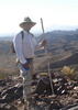
| no partners | | This hike was meant to be with my son but life interrupted so it turned out to be a solo venture. Well as solo as you can get on this popular trail (old baldy trail). I left home at 5:30 am (elev. maybe 200) and was leaving the trail head at 9:30 am and not on a good note. On attempting my first photo I can't see my subject for this flashing light, what is that? Dead battery! AHHhhh!!! What a bone head. Oh well, can't record it but I can still enjoy it, up the trail we go...and up the trail we go..and up the trail...we go. Actually although it was a steady climb this portion wasn't that bad. I was almost always under cover of the canopy, with a great variety of nice scenery. I made Josephine saddle about 11:30 and made sort of a u-turn down the Super trail for .2 miles to Sprung spring to top off my two, one liter bottles. The spring was only putting out maybe a pint a minute but still it was appreciated. After a quick break and a pop-tart I choose to go the Super trail from here. It looks like I'm one of few people to choose this segment. Right away the difference is obvious, where as the trail I'd just left was akin to what you would see in Yosemite valley, I am now on the trail less traveled. The trail is covered with leaves and needles for about the first mile and then the brush closes in and becomes 10,000 ticked off cats clawing at my legs. I'm not wading yet but weaving, which makes the hike tiresome because you can't get a pace or rhythm. This segment has some nice views and plenty of solitude, which I normally enjoy but I was a little unnerved here as I counted 7 piles of bear scat along the way! I did get some practice in breath control trying to sing as I hiked  I finally came out of the brush about the last half mile, past Baldy spring which was dry and climbed up to Baldy saddle at 2:30pm. The wind was blowing through the saddle at 20 + mph and gusting. My legs were spent so I decided to camp here and make the summit in the morning. As I scouted for a flat spot out of the wind I met a small group of young men who had the same plan. They were a bible study group from Green Valley. I had a nice visit with their leader Clint who had been up the mountain several times. He offered for me to camp by them but not wanting to inject myself into their plans I thankfully declined and opted for a more secluded spot, although it was a little comforting knowing they were there. I found a small depression on the leeward side of two small trees that was only slightly more protected. I pitched my tent, ate a cold dinner and explored my surroundings a little as the sun slowly eased over the horizon. This saddle is only 30 yards or so wide here at the crest so as it got darker, I could see the town lights come on far below me to the front and behind. A unique and beautiful experience I took in until a little after sunset. As I climbed into my wind rattled tent I couldn't help wonder if a bear did come exploring, would I be able to hear enough to have some warning. I always hang my food and kitchen, so I took some comfort in that and nodded off...after a bit. The wind finally stopped right before first light. I used the last of my water for oats and tea and because of that I decided to change my plans. I was originally going to follow the crest trail to the four springs trail, to the Kent springs trail and back to the trail head but with no water and not wanting to trust Armour springs to be running, I decided to make this a figure eight and return via Baldy to Josephine saddle and then take the Super trail for the last leg. The climb to the summit was much more enjoyable on fresh legs. I took in the view from the summit for a while,and a rest before I started the long descent. Shortly, I passed a solo lady hiker going up, who must have started in the dark to get here so early and whose legs were tanned and hard from many miles of hiking. Not noteworthy except and at the risk of offending her if I'm wrong but I'd guess she could have been past her seventies. I was inspired. I stopped at Bellows springs to fill my bottles and while there I met Ed, in great shape and 75! Ed has been hiking this mountain for 13 years, before that he worked on the super conductor (atom smasher). We had a great visit as we shared the trail down to Josephine saddle, then parted ways as he remained on Old Baldy trail and I took the Super trail. I really enjoyed the variety of ecosystems you pass through on this hike. The knees appreciated the easier grade as well. About midway down the humidity started to climb and then it began to sprinkle, which soon turned to a light rain and then as I struggled to get my poncho over my pack, somebody unzipped a cloud. Rain and hail were bouncing off the ground! Let me add here that this was my first hike with trekking poles (a trial). Well on this long downhill I had decided they were a good idea, now I was thanking God I had them. The trail was a slick stream bed now and I was hustling to finish and get off the mountain. I couldn't help wonder how many day hikers I had passed were prepared for this, and especially the senior lady I had passed at the top. It rained to within a quarter mile of the parking area, then as desert storms do, the cloud dissolved, and the sky turned blue like nothing happened, which resulted in some strange looks as I walked to my truck with my poncho still on. I wish I could have shared this with my son, but there's always next time. I finally came out of the brush about the last half mile, past Baldy spring which was dry and climbed up to Baldy saddle at 2:30pm. The wind was blowing through the saddle at 20 + mph and gusting. My legs were spent so I decided to camp here and make the summit in the morning. As I scouted for a flat spot out of the wind I met a small group of young men who had the same plan. They were a bible study group from Green Valley. I had a nice visit with their leader Clint who had been up the mountain several times. He offered for me to camp by them but not wanting to inject myself into their plans I thankfully declined and opted for a more secluded spot, although it was a little comforting knowing they were there. I found a small depression on the leeward side of two small trees that was only slightly more protected. I pitched my tent, ate a cold dinner and explored my surroundings a little as the sun slowly eased over the horizon. This saddle is only 30 yards or so wide here at the crest so as it got darker, I could see the town lights come on far below me to the front and behind. A unique and beautiful experience I took in until a little after sunset. As I climbed into my wind rattled tent I couldn't help wonder if a bear did come exploring, would I be able to hear enough to have some warning. I always hang my food and kitchen, so I took some comfort in that and nodded off...after a bit. The wind finally stopped right before first light. I used the last of my water for oats and tea and because of that I decided to change my plans. I was originally going to follow the crest trail to the four springs trail, to the Kent springs trail and back to the trail head but with no water and not wanting to trust Armour springs to be running, I decided to make this a figure eight and return via Baldy to Josephine saddle and then take the Super trail for the last leg. The climb to the summit was much more enjoyable on fresh legs. I took in the view from the summit for a while,and a rest before I started the long descent. Shortly, I passed a solo lady hiker going up, who must have started in the dark to get here so early and whose legs were tanned and hard from many miles of hiking. Not noteworthy except and at the risk of offending her if I'm wrong but I'd guess she could have been past her seventies. I was inspired. I stopped at Bellows springs to fill my bottles and while there I met Ed, in great shape and 75! Ed has been hiking this mountain for 13 years, before that he worked on the super conductor (atom smasher). We had a great visit as we shared the trail down to Josephine saddle, then parted ways as he remained on Old Baldy trail and I took the Super trail. I really enjoyed the variety of ecosystems you pass through on this hike. The knees appreciated the easier grade as well. About midway down the humidity started to climb and then it began to sprinkle, which soon turned to a light rain and then as I struggled to get my poncho over my pack, somebody unzipped a cloud. Rain and hail were bouncing off the ground! Let me add here that this was my first hike with trekking poles (a trial). Well on this long downhill I had decided they were a good idea, now I was thanking God I had them. The trail was a slick stream bed now and I was hustling to finish and get off the mountain. I couldn't help wonder how many day hikers I had passed were prepared for this, and especially the senior lady I had passed at the top. It rained to within a quarter mile of the parking area, then as desert storms do, the cloud dissolved, and the sky turned blue like nothing happened, which resulted in some strange looks as I walked to my truck with my poncho still on. I wish I could have shared this with my son, but there's always next time. |
| _____________________
| I can't stay, so I have to keep moving; but my ambition, is to be there. |
| | |
|
|
|
 Route Editor