Route Editor

| Guide | ♦ | 4 Triplogs | 0 Topics |
details | drive | no permit | forecast | route |
stats |
photos | triplogs | topics | location |
| 53 | 4 | 0 |
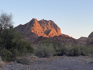
An easy loop for old guys by GrangerGuy  Overview OverviewThis is an easy loop around Muggins Mountain on a fairly easy-to-follow route. The views of the mountains are impressive. There is no shade. On a cool winter Saturday, there were 6 cars at the various parking areas. There are two sensible parking places for this hike, both with plenty of space. One is by a wilderness information kiosk at the end of the road suitable for cars. The second is another half mile or so on a high clearance road, where there is a large campsite. Here the road descends into the wash, and this is the practical limit for driving. Although the non-wilderness corridor continues farther, the wash becomes too narrow for anything but motorcycles or quads, or perhaps a highly modified 4x4. The hike is described from the point the road descends into the wash.
This route is a lasso loop. Where the trail splits at about 0.4 mi, there is an information kiosk with a map, which has some descriptive waypoints shown to help hikers find their way. There are a lot of confusing and extra paths on this route, so photographing the map, or better yet, bringing along a GPS loaded with the route, is a very good idea. The map describes the loop in a clockwise direction, which may be easier for navigation, but the coordinates of one of their waypoints (E) are quite far off, so be careful. The BLM Map Waypoints have been added and corrected in the official HAZ route. In this guide, the loop is described in the counterclockwise direction. From the trail information kiosk, one can walk in the wash due east. Alternatively, there is a path directly behind the kiosk which parallels the wash for about a mile. The path is a little easier walking. All the distances below are from the trail kiosk with the map. About 1.45 miles, the trail bears left up out of the wash and climbs up to the first pass at 2 miles. Views from the pass are pretty good, as you can see several ranges of hills from there. Down the north side of the pass, the trail follows a couple of washes, which seem to have a little more moisture and a little more vegetation. At 3 miles, the trail summits a second pass. From here, you can see 3 tiny windows in the ridge at the top of Muggins Mountain. This pass is in the heart of the mountains, and you can see Muggins, Long Mountain, and Klothos Temple. Coming down from the pass, it is a little steep on loose rock, but nothing terribly difficult. The trail descends to a wash, which becomes the trail almost the whole way back to the kiosk. Along the way, there is a cool slot canyon that begs for lots of pictures. Walking in the wash is easy, although there are a few big steps that are easily managed. You return to the kiosk at 4.65 mi. Flora and fauna There is very little vegetation in this wilderness, especially on the south side of Muggins Peak. It is quite desolate. There is ironwood, palo verde, an occasional saguaro, ocotillo, and chain-fruit cholla. Brittlebush and creosote bush are scattered throughout. Desert lavender is found in the wash west of Muggins Peak. According to the information kiosk, there are Desert Bighorn Sheep, but you may not see any evidence of them on this loop. Check out the Official Route and Triplogs. Leave No Trace and +Add a Triplog after your hike to support this local community. | ||||||||||||||||||||||||||||||||||||||||||||||||||||||||||||||||||||||||||||||||||||||||||||||||