username
X
password
register
for free!
help
ArticlesGuidesRoutes
 
Photosets
 
 Comments
triplogs   photosets   labels comments more
8 triplogs
login for filter options
Feb 07 2013
avatar

 Photos 261
 Triplogs 8

78 male
 Joined Feb 02 2012
 Green Valley, AZ
Chinaman Trail #137Tucson, AZ
Tucson, AZ
Hiking avatar Feb 07 2013
ArizonaBobTriplogs 8
Hiking4.40 Miles 1,019 AEG
Hiking4.40 Miles
1,019 ft AEG
 no routes
1st trip
Linked   none no linked trail guides
Partners none no partners
We wanted to do a less strenuous hike in preparation for tougher adventures as the weather warms. Reading the description by BrettVet, it looked like the Chinaman Trail was perfect.
Turns out, the Jeep drive to the trail head was more of a challenge than the trail :-)
Would strongly suggest high clearance four wheel drive, and 'airing down'.
From Tunnel Spring, the trail seems to go up the mountain, then down to the tunnel entrance. GPS showed a 140 foot drop to the tunnel through loose gravel (and if you hike out and back, you must go UP this part to get back to the parking area).
GPS recorded round trip of 6.6 miles in 4:06 hrs.
A good hike with historical significance along the Arizona Trail.
 Named place
 Named place [ checklist ]
[ checklist ]  Bear Spring  Tunnel Spring
_____________________
 
Jan 03 2013
avatar

 Photos 261
 Triplogs 8

78 male
 Joined Feb 02 2012
 Green Valley, AZ
Atascosa Lookout Trail #100Tucson, AZ
Tucson, AZ
Hiking avatar Jan 03 2013
ArizonaBobTriplogs 8
Hiking5.00 Miles 1,730 AEG
Hiking5.00 Miles
1,730 ft AEG
 no routes
1st trip
Linked   none no linked trail guides
Partners none no partners
Hiked up to the Atascosa Lookout last Thursday. The trail changed from dry to mud to snow covered, depending on what side of the hills we were on. Came upon two washout areas, one minor, the other really took out a large portion of the trail, creating a somewhat challenging scramble to get through the washout area and reach the trail again. I think as more do the hike a defined route will be established.
Since our last hike to the Lookout in February of last year, the trail has become quite overgrown with VERY thorny bushes / branches. I would strongly recommend long pants and long sleeves to fellow hikers at this time.
Met a BP Agent who was tracking 6 illegals who were paralleling the trail to the east. Met a hunter who was tracking 'a Lion and her pups' .... interesting :-)
An excellent cool weather hike... and as Ksorensen said back in 2003, the hardest part is the beginning ... now we add the washout area. Possibly a challenge to inexperienced hikers, but it is not death defying.
 Culture
 Culture [ checklist ]
[ checklist ]  Benchmark
_____________________
 
Dec 16 2012
avatar

 Photos 261
 Triplogs 8

78 male
 Joined Feb 02 2012
 Green Valley, AZ
Guindani TrailTucson, AZ
Tucson, AZ
Hiking avatar Dec 16 2012
ArizonaBobTriplogs 8
Hiking4.25 Miles 1,250 AEG
Hiking4.25 Miles
1,250 ft AEG
 no routes
Linked   none no linked trail guides
Partners none no partners
( I do not know how to delete this )
_____________________
  1 archive
Dec 16 2012
avatar

 Photos 261
 Triplogs 8

78 male
 Joined Feb 02 2012
 Green Valley, AZ
Old Baldy Trail #372 to Wrightson SummitTucson, AZ
Tucson, AZ
Hiking avatar Dec 16 2012
ArizonaBobTriplogs 8
Hiking10.40 Miles 4,000 AEG
Hiking10.40 Miles
4,000 ft AEG
 no routes
Linked   none no linked trail guides
Partners none no partners
Had to see what it was like hiking up the Old Baldy Trail towards Josephine Saddle after the first snow of the season. Photos taken about a half mile from Josephine Saddle. Two youngsters ahead of me said they made it to Baldy Saddle where there was approximately three feet of snow.
_____________________
 
Sep 19 2012
avatar

 Photos 261
 Triplogs 8

78 male
 Joined Feb 02 2012
 Green Valley, AZ
Guindani TrailTucson, AZ
Tucson, AZ
Hiking avatar Sep 19 2012
ArizonaBobTriplogs 8
Hiking4.25 Miles 1,250 AEG
Hiking4.25 Miles   5 Hrs   30 Mns   0.77 mph
1,250 ft AEG
 no routes
Linked   none no linked trail guides
Partners none no partners
Thought I would hike the Guindani trail during the week the Kartchner Caverns were closed for annual maintenance. There was one Jeep Cherokee in the trail head parking lot, and nobody around so I had the trail to myself as there was hardly anyone in the park.
Carrying the excellent description of the hike written in April 2005 by Fricknaly, I headed into the canyon. With additional thanks to the hikers before me who built and maintained the cairns up the canyon, it was easy to find the trail as it crossed the canyon bottom / stream many times.
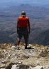
Reaching the saddle was a pleasant surprise as the views were excellent. Now came the hard part. The Monsoons caused the grasses of the higher elevations to really grow tall... above my knees in most areas, making the trail quite hard to find. Maybe this is not a popular hiking trail as I was seeing footprints of a single hiker who had gone before me. I did find the trail by walking 190 degrees from the bare ground location at the saddle. From there, the trail heads gently down the side of the ridge towards Arizona Hy 90 that can be easily seen to the left. I did take my time and was cautious in the high grass, not only because the trail was hard to see, but the person at the entrance said the rattlesnakes have been active recently, and I really did not want to come upon one and rile him / her.
A good hike along the canyon / creek, not to strenuous as the trail climbs out of the canyon, great views at the saddle, and downhill from there.
 Geology
 Geology [ checklist ]
[ checklist ]  Chalcedony
 Culture
 Culture [ checklist ]
[ checklist ]  Mine Shaft
wildflower observationwildflower observationwildflower observationwildflower observationwildflower observation
Wildflowers Observation Moderate
_____________________
 
Jul 19 2012
avatar

 Photos 261
 Triplogs 8

78 male
 Joined Feb 02 2012
 Green Valley, AZ
Jack Mountain LoopTucson, AZ
Tucson, AZ
Hiking avatar Jul 19 2012
ArizonaBobTriplogs 8
Hiking5.00 Miles 2,070 AEG
Hiking5.00 Miles   5 Hrs      1.00 mph
2,070 ft AEG
 no routes
1st trip
Linked   none no linked trail guides
Partners none no partners
Hiked to the Summit of Jack Mountain today thanks to the excellent directions from Fricknaley. Built a cairn to help identify the route to the summit off the Agua Caliente Trail. It looks like the trail is not heavily used, but quite easy to follow. There is some heavier brush near the summit, but again, the trail is visible to the summit.
wildflower observationwildflower observationwildflower observationwildflower observationwildflower observation
Wildflowers Observation Light
_____________________
 
Jul 05 2012
avatar

 Photos 261
 Triplogs 8

78 male
 Joined Feb 02 2012
 Green Valley, AZ
Old Baldy Trail #372 to Wrightson SummitTucson, AZ
Tucson, AZ
Hiking avatar Jul 05 2012
ArizonaBobTriplogs 8
Hiking10.40 Miles 4,000 AEG
Hiking10.40 Miles
4,000 ft AEG
 no routes
Linked   none no linked trail guides
Partners none no partners
I just had to experience being on the trail / at the Summit of Mt Wrightson in the clouds. When waking this morning, I could not see the summit and the temperatures were in the high 60's with no rain predicted .... so fill the bladder, load the back pack and head for the Baldy Trail head. Being on the summit when it is clear and you can see just about forever is beyond fantastic. Hiking up to Josephine, then Baldy Saddles.... and then on to the summit when the clouds are coming up slope, down slope .... one moment visibility is pretty good, the next you are IN the cloud is one of those experiences you have to do for yourself. It clears the mind ... puts a person in perspective ....
wildflower observationwildflower observationwildflower observationwildflower observationwildflower observation
Wildflowers Observation Moderate
_____________________
 
May 31 2012
avatar

 Photos 261
 Triplogs 8

78 male
 Joined Feb 02 2012
 Green Valley, AZ
Roger's RockTucson, AZ
Tucson, AZ
Hiking avatar May 31 2012
ArizonaBobTriplogs 8
Hiking4.50 Miles 1,450 AEG
Hiking4.50 Miles
1,450 ft AEG   1 Hour    Break12 LBS Pack
 no routes
1st trip
Linked   none no linked trail guides
Partners none no partners
I followed the detailed hike summary written by Fricknaley dated August 2008 and found Roger's Rock without any problems thanks to the detailed instructions. I believe that since the narrative was written, some of the pipes have been removed along the 'Pipeline' trail, and the pipes that the narrative says to go under have been removed as well, but the support remains, so not all that difficult to figure out.
The trail has little exposure so is an excellent hike on the hotter Arizona days. It is also through pine and Sycamore forest. Do watch for black bear, especially in the trees as some have been seen in the area.
 Named place
 Named place [ checklist ]
[ checklist ]  Rogers Rock - Santa Ritas
wildflower observationwildflower observationwildflower observationwildflower observationwildflower observation
Wildflowers Observation Light
_____________________
 
average hiking speed 0.89 mph

WARNING! Hiking and outdoor related sports can be dangerous. Be responsible and prepare for the trip. Study the area you are entering and plan accordingly. Dress for the current and unexpected weather changes. Take plenty of water. Never go alone. Make an itinerary with your plan(s), route(s), destination(s) and expected return time. Give your itinerary to trusted family and/or friends.

helpcommentissue

end of page marker