 Route Editor

| Guide | ♦ | 59 Triplogs | 1 Topic |
details | drive | permit | forecast | 🔥 route |
stats |
photos | triplogs | topic | location |
| 562 | 59 | 1 |
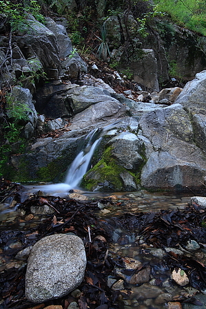
Yes, this is Tucson...I swear by fricknaley   Summary SummaryHere's a swift little loop through some lightly untraveled trails to a nice rock outcropping overlooking Madera Canyon. You may have trouble believing this hike is in Tucson... Hike This trail takes off on the Super Trail, from the ever-present trailhead at the end of the road into Madera Canyon, home of the Super Trail and Old Baldy Trail. Take off on the Super trail and follow it just past the first creek crossing. The trail will soon start switchbacking. After the first hard right, look for a definite dirt path leading off the trail and heading up left. Take this route up, which the Santa Rita faithful refer to as the Pipeline Route. It is only about 0.3-miles ( more info ) up the Super Trail where this route takes off.
The pipeline runs overhead to the right, and the Kent Spring trail cuts hard over the creek and breaks away left. At the crossing, go under the pipe and head up the creek away from the Kent Spring Trail. Immediately you will pick up the route again, first on the right side of the creek, then crossing over to the left. The next ~0.65-miles climb up along the creek and cut through some of the prettiest forests in the Santa Ritas. Ferns are everywhere, and pines litter the trail with their fragrant needles. Mossy old rocks dot the creekside, and during monsoon season, the creek flows. You could spend all day on this all too short trail. After about ~0.65-miles from the creek crossing, you will come to a second creek crossing, where the trail abruptly swings right over the creek. Just before this, notice a well-defined path-breaking off left. This is the trail to Rogers Rock. Take this lovely little trail for about 0.2-miles and look up to your right, where you will see a couple of established trails running up to a huge rock sitting amongst the trees... Roger's Rock. Make sure to climb up around the back onto the top where you get fantastic views over Madera Canyon and looking west over to Pete Mountain. I don't know the exact elevation of the rock. I got about 6437 on my GPS. Climb back down and pick up the trail again. If you continue past the Rock, it quickly peters out at an old establishment site littered with old metal and such... long gone and forgotten, I guess. Head back to the upper creek crossing. Here you can go back right and return the way you came or make a left and cross over the creek. The trail climbs up briefly for about 0.25-miles or so to join back up with the Super Trail, which you can now follow back down for roughly 2-miles to your car and complete an outstanding 4.5-mile loop. I want to thank Santa Rita expert and HAZ member Saguarohiker (Bill) for the beta on this outstanding little loop hike through some gorgeous Santa Rita country. Check out the Official Route and Triplogs. Leave No Trace and +Add a Triplog after your hike to support this local community. | ||||||||||||||||||||||||||||||||||||||||||||||||||||||||||||||||||||||||||||||||||||||||||||||||||||||||||||||||||||||||||||||||||||||||||||||||||||||||||||||||||||||||||||||||||||||||||||||||||||||


