 Route Editor

| Guide | ♦ | 37 Triplogs | 0 Topics |
details | drive | permit | forecast | 🔥 route |
stats |
photos | triplogs | topics | location |
| 231 | 37 | 0 |
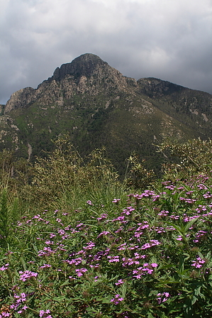
You don't know Jack...well now you do! by fricknaley  Summary SummaryJack Mountain sits between the famous Mt. Wrightson to the east and Mt. Hopkins to the west. This little peak offers some of the best views in the Santa Ritas and is a blast to climb as well. Several routes can be put together to make a nice loop. This one will consist of going up Old Baldy Trail #372 to Josephine Saddle, then heading west on Agua Caliente Trail #140 to Jack, then coming back down on the Carrie Nation Trail #78. You could also use Super Trail and/or Vault Mine trails as additional routes to and fro. Hike From the ubiquitous trailhead at the end of the Madera Canyon Road, take off, heading south on the landmark Old Baldy trail. This is a well-known trail, and well known to Hike Arizona, so I won't belabor the details. It is 2.2 miles of lovely, steady climbing up Old Baldy to the intersection of trails at Josephine Saddle. This saddle can be seen from all over the Santa Ritas and Tucson, too, for that matter. It's about a 1600 foot climb to Josephine Saddle from the Baldy trailhead. Much of this trail is gorgeous.
Head down the steep Carrie Nation trail as it descends through wonderfully shaded pine forest to access the canyon. There are all sorts of juvenile and full-grown pines along the upper section, making it splendid. The trail eventually meets the canyon then skirts along either side of it for about 0.6 miles, at which point you will come to an "End of Trail" sign, marking the upper end of the "maintained" Carrie Nation trail. The thing is, the route above this, which you just descended, is just as easy to follow as the maintained trail. At the end of trail region, there is an old mine site. Cross over the creek/canyon to the west side and pass by some old machinery. The trail picks up and heads down along a canyon to your right. The trail is very shaded here, and you may be lucky to spy or hear an Elegant Trogan in this area, I have in the past. After about 0.8 miles of easy descending, you will come to the signed break-off for the Vault Mine trail, which heads up to your left. There is a sign marking the way down to the trailhead. Continue down the last 0.7-0.8 miles to the trailhead and your car. Madera Creek will be on your left on the way down. I'd like to thank fellow HAZ member Saguarohiker (Bill) for the beta on the spur trail to the Jack summit. He is the resident expert on all things Santa Ritas. Check out the Official Route and Triplogs. Leave No Trace and +Add a Triplog after your hike to support this local community. | ||||||||||||||||||||||||||||||||||||||||||||||||||||||||||||||||||||||||||||||||||||||||||||||||||||||||||||||||||||||||||||||||||||||||||||||||||||||||||||||||||||||||||||||||||||||||||||||||


