 Route Editor

| Guide | ♦ | 15 Triplogs | 0 Topics |
details | drive | permit | forecast | 🔥 route |
stats |
photos | triplogs | topics | location |
| 239 | 15 | 0 |
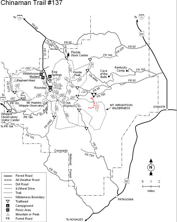
Historic Hike with great views by BrettVet   The Santa Rita mountain trails usually go only in two directions, straight up or straight down. The Chinaman trail is a relatively easy flat trail that takes you into a remote canyon with outstanding views across the Sonoita valley. Mostly unaffected by forest fires, it is a little-used well-marked trail that is much nicer than the nearby Gardner canyon trail that goes straight up to the Super Trail through rubble and a burned area. The bottom line is if you want a leisure day hike in the Santa Ritas, this is your trail. The Santa Rita mountain trails usually go only in two directions, straight up or straight down. The Chinaman trail is a relatively easy flat trail that takes you into a remote canyon with outstanding views across the Sonoita valley. Mostly unaffected by forest fires, it is a little-used well-marked trail that is much nicer than the nearby Gardner canyon trail that goes straight up to the Super Trail through rubble and a burned area. The bottom line is if you want a leisure day hike in the Santa Ritas, this is your trail.Getting to the trailhead is almost effortless with four-wheel drive but can be done in a high clearance car, especially for a rental car. There are several creek crossings, but for the most part, the road is well graded. If you don't have the 4x4, you can park at the Arizona trailhead just past the ranch houses on the way into Gardner canyon and take the Arizona trail south. This adds about 3 miles of easy hiking to the trip and is less scenic than the Casa Blanca Canyon.
The Chinaman Trailhead is at the round metal stock tank with a sign that says tunnel springs and the Arizona Trail (signs are politically correct). Do not continue on the road up the hill to Gardner Canyon Trailhead. Take the trail up over the hill to the south into Casa Blanca Canyon to pick up the other side's ditch/trail. You will encounter another larger stock tank, and the ditch/ trail will hug the canyon wall. After about a mile, there will be a small tunnel through some boulders, and after about 2.6 miles, the ditch will end at bear spring. Bear spring is an excellent place to turn around because from here, the trail goes straight uphill for about 1.5 miles to intersect the Walker Canyon trail. You can make this a loop hike by taking the Walker Canyon trail 1.5 miles over to the Gardner Canyon trail then down the 4x4 road back to Tunnel Springs. The Walker Canyon trail is closed due to fire damage and erosion but passable at your own peril. I would not recommend it because the trail and views are pretty bleak due to the fire, and there is a lot of road hiking.
Check out the Official Route and Triplogs. Leave No Trace and +Add a Triplog after your hike to support this local community. One-Way Notice This hike is listed as One-Way. When hiking several trails on a single "hike", log it with a generic name that describes the hike. Then link the trails traveled, check out the example. | |||||||||||||||||||||||||||||||||||||||||||||||||||||||||||||||||||||||||||||||||||||||||||||||||||||||||||||||||||||||||||||||||||||||||||||||||||||||||||||||||||||||||||||||||||||||||||||||||||


