username
X
password
register
for free!
help
ArticlesGuidesRoutes
 
Photosets
 
 Comments
triplogs   photosets   labels comments more
5 triplogs
login for filter options
Nov 25 2018
avatar

 Routes 5
 Triplogs 5

44 male
 Joined Dec 12 2013
 Phoenix, AZ
Ballantine Cabin & CorralPhoenix, AZ
Phoenix, AZ
Hiking avatar Nov 25 2018
mrbeermugTriplogs 5
Hiking11.11 Miles 2,416 AEG
Hiking11.11 Miles   5 Hrs   14 Mns   2.29 mph
2,416 ft AEG      23 Mns Break
 no routesno photosets
1st trip
Linked   none no linked trail guides
Partners none no partners
Perfect day for a Ballantine hike. Well marked trail on the way up to the first saddle with a trail marker at mile 1.5. Option at the start of the trail to either turn left or right, with both options head to the same junction 1.5 miles in.

Everything was well marked but long pants and good boots recommended since there's a lot of catclaw and other thorny bushes you have to push through on the return section of the loop. Path is Not well marked on the eastern side when heading mirth past the corral so having the GPS route made it easier than it otherwise would've been. Crazy how well used the metal cabin seems to be, not sure if for smugglers or wanderers but still some unopened cans of food in there and other pots and pans. Saw a tarantula on trail but surprisingly no rattlesnakes.
_____________________
 
Nov 10 2018
avatar

 Routes 5
 Triplogs 5

44 male
 Joined Dec 12 2013
 Phoenix, AZ
Peralta to Fremont SaddlePhoenix, AZ
Phoenix, AZ
Hiking avatar Nov 10 2018
mrbeermugTriplogs 5
Hiking5.57 Miles 1,568 AEG
Hiking5.57 Miles   4 Hrs   21 Mns   1.61 mph
1,568 ft AEG      53 Mns Break
 no routesno photosets
1st trip
Linked   none no linked trail guides
Partners none no partners
Great trail as always. Saw a baby tarantula and a horned lizard. Plenty of people taking the Cave Trail back to bluff springs for a loop as well - that spur is now much better marked than in previous years. Only a few went over the saddle and deeper into the Superstitions.
_____________________
 
Mar 17 2018
avatar

 Routes 5
 Triplogs 5

44 male
 Joined Dec 12 2013
 Phoenix, AZ
Mazatzal Peak SummitPayson, AZ
Payson, AZ
Hiking avatar Mar 17 2018
mrbeermugTriplogs 5
Hiking11.75 Miles 4,400 AEG
Hiking11.75 Miles
4,400 ft AEG
 
no photosets
1st trip
Linked   none no linked trail guides
Partners none no partners
GPS Route Posted: [ gps route ]

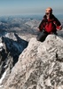
On 3/3 there was certainly some snow on the barnhardt side and near the peak, but not as much as we expected as a result of the dry winter. I think this was about my fourth time up the mountain, all ascending from the Y-Bar trail, whereas most people appear to start at Barnhardt and descend Y-Bar, so I think our route is a better ascent. Over the years my hiking partner Brett and I have discovered a great route up to the summit that we've got pretty decently cairned at this point. Found most of our cairns from prior years on the way up and reinforced them. Our route doesn't follow the popular ridge up, but it isn't too overgrown.

Once you reach the saddle after climbing the Y Bar Trail, level out, and just start to descend, you make a right turn off the main trail to start your traverse through some old white trees burned out by a wildfire. You continue the traverse across and uphill below the base of the cliff area but rather than climb up the ridge that others do, continue west through the wide horseshoe drain and go up a narrow chute on its west side before getting to the cliffs. Always stay east of the cliffs and continue to scramble up a second and third chute that gradually transition from loose scree and dirt into better rock stair footing.

After the third chute, keep your eye open for some cairns and an incredible little narrow pinch between two large rocks. Go into the pinch and with two steps up you can hoist yourself about 8' onto the top and you're out of the chute area. Traverse
along the light path slightly below and west of the ridge you are on and then it's just a short and more gradual hike up north and west to the summit. Proceed east and north down to the Barnhardt trail to complete the loop.

Great hike, and loved spotting a bunch of agave filifera on the way down barnhardt, since they're rare in AZ and we'll be planting some in our yard soon.

-mrbeermug
_____________________
  1 archive
Sep 21 2014
avatar

 Routes 5
 Triplogs 5

44 male
 Joined Dec 12 2013
 Phoenix, AZ
Jug Trail #61 - Salome WildernessGlobe, AZ
Globe, AZ
Canyoneering avatar Sep 21 2014
mrbeermugTriplogs 5
Canyoneering3.50 Miles 500 AEG
Canyoneering3.50 Miles
500 ft AEG
 no routesno photosets
1st trip
Linked   none no linked trail guides
Partners none no partners
Hiked to the creek today with my rappel gear given the many recent rains, but the creek was nearly dry. Downclimbed in mid-canyon near what is normally one of the water slides, but what would normally be a full on swim during the late spring was now just very shallow sets of standing pools that could be largely hopped past by staying to the jug canyon edges. Decided not to bother heading to the rappel given the lack of water and surely dry waterfall.....snapped a few pics and climbed back out. Will wait until the spring to return!
_____________________
 
Sep 03 2014
avatar

 Routes 5
 Triplogs 5

44 male
 Joined Dec 12 2013
 Phoenix, AZ
Grand Teton (Summit via Exum Ridge), WY 
Grand Teton (Summit via Exum Ridge), WY
 
Climbing avatar Sep 03 2014
mrbeermugTriplogs 5
Climbing21.00 Miles
Climbing21.00 Miles1 Day   8 Hrs      
 no routesno photosets
1st trip
Linked   none no linked trail guides
Partners none no partners
Summited the Grand Teton via Upper Exum Ridge climb with Exum Guides in a 1:1 climb on 9/3/2014. The Grand had already been starting to get snow/ice accumulation just prior to our 2 day climb so conditions on the Owen Spalding and Lower Exum Ridge were not great.....we decided to ascend via the Upper Exum Ridge climb and descend through the Owen Spalding.....the descent was more treacherous by far than the clmib since the Owen Spalding had lots of snow and ice, was shaded and had sustained gale force winds (60+ mph with gusts at 80+mph).

Day 1 was depart from Lupine Meadows trailhead for a ~ 5,000 ft elevation gain and 7 mile non-technical trek with full 25 lb pack and only one brief roped-in 4th class scramble (quick and dirty belay using a bowline around the waist but no harness) near the top of the lower saddle. Up the Lupine Meadows trail you stay straight at the first junction, then left at the second junction and head up into Garnet Canyon. Cross a large boulder field, and beautiful meadow with campsites and a water source you can drink straight from the spring, another boulder field, and then a steep scramble up to the lower saddle with the Middle Teton and its glacier directly ahead. 10am depart - 5pm arrive.

Day 2 - 3am wakeup at the hut on the lower saddle, 4am depart, 9:30am at the summit, 12:30pm back at the hut for lunch, 1:30pm-5pm hike back down to Lupine Meadows trailhead.
_____________________
 
average hiking speed 1.95 mph

WARNING! Hiking and outdoor related sports can be dangerous. Be responsible and prepare for the trip. Study the area you are entering and plan accordingly. Dress for the current and unexpected weather changes. Take plenty of water. Never go alone. Make an itinerary with your plan(s), route(s), destination(s) and expected return time. Give your itinerary to trusted family and/or friends.

helpcommentissue

end of page marker