 Route Editor

| Guide | ♦ | 7 Triplogs | 0 Topics |
details | drive | permit | forecast | 🔥 route |
stats |
photos | triplogs | topics | location |
| 120 | 7 | 0 |
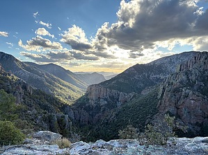
Formerly known as Whitewater Canyon by Jackluminous   Overview OverviewRucker Canyon Trail #222 is a spectacular canyon hike in the southern Chiricahua Mountains. Originally called Whitewater Canyon because of the raging rapids that would accompany monsoon rains, it was renamed Rucker Canyon in the 1870s after John Rucker, a soldier stationed at a nearby army camp, lost his life trying to save one of his fellow servicemen being swept away by a flood. It's good to remember this story as flooding is a frequent problem in Rucker Canyon, and the trail has been damaged many times in the past. As of October 2025, the trail is in generally excellent condition, with the canyon portion completely restored. Inevitably, there will be washouts, deadfall, and overgrowth at times. But despite this, Rucker Canyon is always a fabulous place to explore and experience natural grandeur.
The trailhead used to be a Forest Service campground called Rucker Forest Camp, which was removed in 2022 due to flood damage. There are concrete barriers to prevent vehicle access, but you can still carry your gear and tent camp. This trail can be roughly divided into three sections: a forested canyon hike, a steep series of switchbacks to a rock outcrop, and an unmaintained brushy ridge hike to its eastern terminus with the Price Canyon Trail. Canyon Hike The first 2.7 miles follow the creek up the canyon, crossing it many times. New tread on the north bank briefly switchbacks high up the side of the canyon to avoid a particularly flood-prone spot before descending back down to the creek and crossing it. The creek is generally perennial, and when flows are high, the creek crossings can become difficult with dry feet. There are occasional small waterfalls and pools large enough to swim in. At times, the water takes on a turquoise hue. Water will be highest after monsoon rains or during spring snow melt. Near the end of the canyon, just as it starts the switchbacks to the rock outcrop, is a broad wooded camping area. Many hikers turn around at this point, as the rest of the trail is more difficult. Side Excursion to Rucker Canyon Grottoes: From here, it is possible to continue following the canyon off-trail to the Rucker Gates. The Gates are 700-foot rhyolite cliffs on either side of a narrowing in the canyon about 3/4 of a mile up-canyon from the camping area. Proceeding another 1/4 mile up-canyon brings you to the Rucker Canyon Grottoes, a series of large grottoes hewn into the canyon walls. There are a few caves beyond the grottoes as well. This is a challenging off-trail adventure with many obstacles to contend with, including overgrowth, deadfall, boulders, and frequent stretches of walking in the creek. Switchbacks After leaving the canyon floor, Rucker Canyon Trail proceeds up the south face of the canyon with a series of seemingly endless switchbacks. The forest thins somewhat as the trail climbs, yielding some great views of the north side of the canyon, including the Rucker Gates. At the top of the switchbacks, about 1.2 miles from the canyon floor, is a rock formation resembling a cliff dwelling. It is a great spot for a break. This also happens to be the junction for the Red Rock Canyon trail, which follows the ridge to the right and will take you to Sage Peak. The Rucker Canyon Trail continues, following the ridge to the left. Most of the hikers who come this far turn back at this point. The rest of the trail is unmaintained and requires some route-finding skill and a willingness to contend with frequent oak brush overgrowth. Ridge Hike Should you be one of those who prefer to see things to the very end, you'll proceed along the ridge. The ridge hike is brushy and overgrown, not having been maintained in many, many years. Despite this, it actually isn't terribly difficult to hike the ridge, trail or no trail. A little over a half mile is a wonderful, clear spot to spend the night, you will be treated to spectacular sunset and sunrise views of Rucker Canyon looking west. This is also right before the final drop into Price Canyon, which is choked with oak, sticker bushes, and deadfall. The tread is actually in good shape under all that, but you will definitely need the right frame of mind to reach the trail junction. Update As of February 2026, reports are that trail crews have cleared the ridge all the way to the trail's terminus with Price Canyon Trail. Hooray!
Check out the Official Route and Triplogs. Leave No Trace and +Add a Triplog after your hike to support this local community. One-Way Notice This hike is listed as One-Way. When hiking several trails on a single "hike", log it with a generic name that describes the hike. Then link the trails traveled, check out the example. | |||||||||||||||||||||||||||||||||||||||||||||||||||||||||||||||||||||||||||||||||||||||||||||||||||||||||||||||||||||||


