Route Editor

| Guide | ♦ | 5 Triplogs | 1 Topic |
details | drive | permit | forecast | route |
stats |
photos | triplogs | topic | location |
| 65 | 5 | 1 |
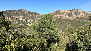
Sunny climb from Powers Garden to West Divide by jacobemerick  Overview OverviewThis trail is a direct, sunny climb from Powers Garden to the West Divide along an exposed ridge. It is a sweaty way to reach Tent Lookout, which is why it used to be called the Tent Lookout Trail. It can also be used to make for some loops to the south that include Powers Cabin, Grassy Knoll, and the southern end of Powers Garden trail. Note The modern name for this trail is Field Canyon #294... though it never actually touches the main drainage or the tributaries for the actual Field Canyon. Also, it is south of "South Field Canyon Trail #294A". Names are funny.
Starting just south of Powers Garden and the old cabins there, Field Canyon Trail is on the west side and has a leaning (as of 2025) signpost to mark the west-leading tread. For the first quarter mile the trail sticks to a shallow drainage and is mostly shaded, slowly gaining elevation, with only one or two switchbacks. At 0.4 miles the tread finally tops the ridge at a small, nondescript saddle, and splits -- South Field Canyon Trail heads north and into the South Field Canyon drainage, while Field Canyon turns south and starts climbing with vigor. This is a good spot to turn around and remind yourself that you've already gained a few hundred feet and have earned a good view back down in the valley. There's over a thousand feet of elevation to go, and it's all about the same -- some switchbacks, some overgrowth from manzanita and willow, and great views to the east and south. The tread is relatively easy to follow over the crushed white rocks, and the exposed slopes have slow growth, so hiking up should be fairly bloodless. At the top of the trail, after catching your breath, you could turn right to find the small spur trail off the West Divide that leads to Tent Lookout, an old fire watch site that could make for a lovely campsite. You could also continue north to make a loop with South Field Canyon Trail or south for a longer loop. Either way, pat yourself on your sweaty back for surviving that climb. Water Sources None. Water up at Powers Garden Spring before hauling up this climb. Camping The hillside and trail are too steep to support any sizeable campsite. However, Powers Garden is a fantastic (if chilly) camping destination, and there is enough room on Tent Lookout for a few tents. Check out the Official Route and Triplogs. Leave No Trace and +Add a Triplog after your hike to support this local community. | ||||||||||||||||||||||||||||||||||||||||||||||||||||||||||||||||||||||||||||||||||||||||||