username
X
password
register
for free!
help
  

Juniper Spring Trail #271A, AZ

Guide 1 Triplog  0 Topics
  2 of 5  
Fav
Wish
0
details
drive
permit
forecast
route  
stats
photos
triplog
topics
location
71 1 0
Statistics
tap row or icons for details
Difficulty 2.5 of 5
Route Finding 2 of 5
Distance One Way 0.9 miles
Trailhead Elevation 5,019 feet
Elevation Gain 357 feet
Accumulated Gain 365 feet
Avg Time One Way 0.5
Kokopelli Seeds 2.12
 Interest Seasonal Creek
 Backpack Yes & Connecting
unreported if dogs are allowed
editedit > ops > dogs to adjust
feature photo
Photos Viewed All MineFollowing
Inaugural Calculation on Button Tap!
71  2024-04-13
West Divide Loop - Galiuro Mountains
jacobemerick
Author
author avatar Guides 38
Routes 182
Photos 1,602
Trips 232 map ( 2,731 miles )
Age 40 Male Gender
Location Gilbert, AZ
Associated Areas
list map done
Tucson Region
Historical Weather
Trailhead Forecast
Radar Map
Expand Map
Preferred Mar, Apr, Oct, Nov → 7 AM
Sun  5:59am - 6:41pm
Official Route & 1 Rt
 
1 Alternative


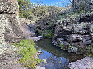
A little spur to a little spring
by jacobemerick

Overview
Short spur trail that slowly climbs from Pipestem Trail #271 to a dependable spring. May also connect to ranching trails north of the Galiuro Wilderness.


Hike
The trail starts a dozen yards west of the drainage, connecting to Pipestem at an unsigned break in manzanita. There are hints of tread that swings toward the drainage and then follows it upstream. It's difficult to keep on the tread and may be easier to jump in and out of the drainage, as both the trail & the drainage will lead you right to the spring.
remove free decal offer
There are some interesting sights along the way, including a few red rock tanks and a large, chunky alcove. The drainage has steep sides, so there are no grand vistas, just cool small things along the route. Tread is faint and not terribly overgrown with spiky plants. Near the end, there is a neat slickrock area that may have trickling water.

Directly above the slickrock, the drainage splits evenly, with Juniper Spring on the left split. There is a large campsite located between the splits, and at least two curious treads that continue (one north, one west). I suspect the northern one may be a cattle/rancher path that connects to Fourmile, but didn't check it out. From here you may either camp, water up, or simply circle back to Pipestem and continue on your trip.

Water Sources
Juniper Spring is the obvious one, this trail seems designed primarily to access it. Pipestem Creek seems fairly dependable, so maybe this trail & spring is for dry seasons?

Camping
There is a nice campsite near the spring, as long as you can avoid the numerous cow patties.

2025-03-26 jacobemerick


    Check out the Official Route and Triplog.
    Leave No Trace and +Add a Triplog after your hike to support this local community.

    One-Way Notice
    This hike is listed as One-Way.

    When hiking several trails on a single "hike", log it with a generic name that describes the hike. Then link the trails traveled, check out the example.
    WARNING! Hiking and outdoor related sports can be dangerous. Be responsible and prepare for the trip. Study the area you are entering and plan accordingly. Dress for the current and unexpected weather changes. Take plenty of water. Never go alone. Make an itinerary with your plan(s), route(s), destination(s) and expected return time. Give your itinerary to trusted family and/or friends.

     Permit $$
    None

    Coronado Forest
    MVUMs are rarely necessary to review unless mentioned in the description or directions
    Coronado Motor Vehicle Use Maps (MVUMs)


     Directions
    or
     Road
    Connector trail - Not Applicable

    To hike
    page created by joebartels on Mar 26 2025 1:01 pm
     90+° 8am - 6pm kills
    helpcorrectionissue

    end of page marker