 Route Editor

| Guide | ♦ | 1 Triplog | 1 Topic |
details | drive | permit | forecast | route |
stats |
photos | triplog | topic | location |
| 71 | 1 | 1 |
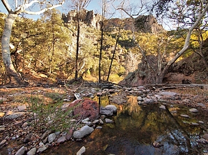
Pleasant creekside stroll to West Divide by jacobemerick   Overview OverviewPipestem Trail follows Pipestem Creek from its end at Rattlesnake Creek up to its source by Maverick Mountain. Neither end is near a trailhead. Instead, this trail provides a convenient connection between the interior of the Galiuro Wilderness and the West Divide, providing some good backpacking loop options. Hike This trail starts at Rattlesnake Creek when it turns northeast and heads out of the Galiuro Wilderness. Hikers will likely access this spot by hiking in from Sycamore & Rattlesnake Trails or by coming down from Powers Hill (if the private road is open). To reach the trail, you will need to cross Rattlesnake Creek at the Pipestem Creek confluence. Rattlesnake is usually flowing here, often quite deep, and may be difficult to cross.
Water is relatively plentiful along the creek, with several promising tanks that look dependable year-round, though there is one dedicated spur at 1.8 miles to a fallback water source. Juniper Springs Trail is a short, less-than-a-mile hike up a rocky creek to a good soupy spring. Shortly after that spur is one of the worst sections of trail that sane hikers will likely want to bypass. Otherwise, most of the trail is surprisingly clear, regularly used by either hunters or animals. At 4.0 miles there's a fork, and it does appear that a path may connect to the West Divide from here, but you can also continue within the creek. There are several unmarked water tanks close to where West Divide brushes up against the upper end of Pipestem, and as there are no water sources along the West Divide until Kielberg, this is a good place to fill a few containers. The trail ends at the northern tip of the West Divide Trail with good views of Maverick Mountain dominating the horizon. From here you could backtrack, or you could continue onto fantastic adventures on the Divide. Water Sources There are multiple tanks along Pipestem Creek even if its not actively flowing. Also, Juniper Springs is a short spur away. Camping Several camping sites along the way, including one at Juniper Springs and another at the "red rock tanks" at 1.8 miles. Check out the Official Route and Triplog. Leave No Trace and +Add a Triplog after your hike to support this local community. One-Way Notice This hike is listed as One-Way. When hiking several trails on a single "hike", log it with a generic name that describes the hike. Then link the trails traveled, check out the example. | ||||||||||||||||||||||||||||||||||||||||||||||||||||||||||||||||||||||||||||||||||||||||||||


