Overview
This mainly east-west orientated connector trail is located in the south-central part of the McDowell Sonoran Preserve North (MSPN). The east side of Vaquero Trail transects the Powerline Road #2 Trail near the northern terminus of the 118th St Trail. The west side junctions at a four-way intersection with the Brown's Ranch Road Trail and the eastern terminus of the Wrangler Trail.
Synopsis
It's a slightly winding, gently rolling path with minimal sand that would seem to be a good beginner equestrian ride. The eastern half closely parallels the power lines, but consequently, the views north of Cholla and Little Granite Mountains make up for this carbuncle.
When hiking several trails on a single "hike", log it with a generic name that describes the hike. Then link the trails traveled, check out the example.
WARNING! Hiking and outdoor related sports can be dangerous. Be responsible and prepare for the trip. Study the area you are entering and plan accordingly. Dress for the current and unexpected weather changes. Take plenty of water. Never go alone. Make an itinerary with your plan(s), route(s), destination(s) and expected return time. Give your itinerary to trusted family and/or friends.
Permit $$
None
Directions
Road
Connector trail - Not Applicable
To Brown's Ranch Trailhead From the 101 in North Scottsdale, drive North on Pima/Princess drive and go East on Happy Valley Road to the stop sign at the instersection of Happy Valley & Alma School Road. Follow Alma School Road North past Dynamite until it ends at Brown's Ranch Trailhead.
From PHX (I-10 & AZ-51) 34.0 mi - 44m From TUC (Jct 1-10 & Grant) 135 mi - 2h 4m From FLG (Jct I-17 & I-40) 139 mi - 2h 15m
 Route Editor

 Overview
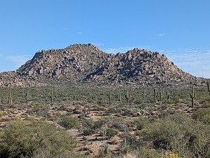


