 Route Editor

| Guide | ♦ | 4 Triplogs | 0 Topics |
details | drive | no permit | forecast | route |
stats |
photo | triplogs | topics | location |
| 1 | 4 | 0 |
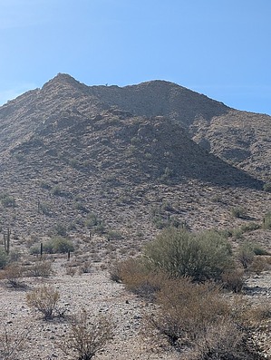
That Weird Ax-Licking by pseudalpine  Peppermint! What I've been searching for all my life! I've struck it rich. I've got me a peppermint mine ... Wahoooo!" Sorry Yukon, it was probably just silver and gold. You'll have to keep illegally searching the multitude of other shafts in the area. Peppermint! What I've been searching for all my life! I've struck it rich. I've got me a peppermint mine ... Wahoooo!" Sorry Yukon, it was probably just silver and gold. You'll have to keep illegally searching the multitude of other shafts in the area.Overview A pick-your-poison, predominantly schist ridgeline hike located in the northeast Goldmine Mountain subrange of the San Tan Mountain Regional Park. It's not quite the highpoint of the main San Tan Mountains considering farther west on the Gila River Indian Community is Santan Mts (Gila) Peak 3104. Also, a bit higher are Malpais Hills 2539 to the southwest and the 2463 subpeak farther west of benchmarked Goldmine Mountain.
Gaps NW of Oro Ridge near N Borgata Trl. Once in the park, there's an obscure trail here and there, and tracking the more westerly ridges could elicit more neighborly respect and avoid barking dogs from some of their backyards. From the highly littered summit, the true west side ridge is more technical and interesting with an arch near the saddle before the mines. Southeast of the saddle, one meanders steep bajadas through shallow arroyos until another border corner limbo. A current hodgepodge of bestrewn UTV trails crisscrosses this private desert to other legal street parking options. Synopsis A similarly straightforward hike as the east side Maricopa Peak approach in South Mountain and many of the less complicated listed at TrailDEX filter: Phoenix SW peaks. Currently, this ascent has limited approach restrictions, but this may change as the north section of Borgata bordering this preserve corner develops further. It's a common denominator of our sprawl into these previously primordial areas.
Check out the Official Route and Triplogs. Leave No Trace and +Add a Triplog after your hike to support this local community. One-Way Notice This hike is listed as One-Way. When hiking several trails on a single "hike", log it with a generic name that describes the hike. Then link the trails traveled, check out the example. | |||||||||||||||||||||||||||||||||||||||||||||||||||||||||||||||||||||||||||||||||||||||||


