username
X
password
register
for free!
help
 
  🔥

Boulder Mountain, AZ

Guide 5 Triplogs  0 Topics
  4 of 5  
Fav
Wish
0
details
drive
no permit
forecast
🔥
route  
stats
photos
triplogs
topics
location
128 5 0
Statistics
tap row or icons for details
Difficulty 4 of 5
Route Finding 3 of 5
Distance Round Trip 10.42 miles
Trailhead Elevation 2,399 feet
Elevation Gain 3,898 feet
Accumulated Gain 3,956 feet
Avg Time Round Trip 6-8 hours
Kokopelli Seeds 30.2
 Interest Off-Trail Hiking & Peak
 Backpack Possible - Not Popular
feature photo
Photos Viewed All MineFollowing
Will recalculate on button tap!
9  2025-03-22 BobP
25  2025-03-22 chumley
43  2025-03-22 John10s
35  2022-12-07
Boulder Mountain
LJW
15  2019-12-09
Boulder Mountain
LJW
Author
author avatar Guides 94
Routes 840
Photos 22,055
Trips 1,993 map ( 15,547 miles )
Age 52 Male Gender
Location Tempe, AZ
Historical Weather
Trailhead Forecast
Radar Map
Expand Map
Preferred Feb, Oct, Nov, Mar → Early
Seasons   Early Autumn to Late Spring
Sun  6:02am - 6:46pm
Official Route & 3 Rts
 
2 Alternative
 
Historic Fire Perimetersacres
🔥 2020 Bush Fire193.5k
🔥 2005 Edge Complex Fire72.3k
🔥 View (All) - over Official Route 🔥


Don't be a shy pebble, be a little boulder!
by chumley

 
Overview
This mountain stands between the commonly recognizable Four Peaks and Mt. Ord in the southern half of the Mazatzal Mountains. There is no trail. This summit can be reached from several directions, but this is the most common and direct non-technical approach.


Hike
While there is no established route to the summit of Boulder Mountain, the best way to access the summit begins from Round Valley along the Beeline Highway. Forest Road 1704 leads from the highway across Sycamore Creek and through a maze of spur roads and dispersed campsites before consolidating into a defined two-track that heads uphill about half a mile from the start. This is definitely a "jeep road". A capable vehicle paired with an experienced driver can drive much of this road, but this description assumes most will walk the road -- mostly because it would not save much (if any) time to attempt to drive it.
remove free decal offer
Begin the hike at the 2400-foot contour, just before the road begins to climb out of the flat terrain of Round Valley. After about 3.5 miles of hiking on the rough road, it's time to begin the direct ascent toward the summit. (The point for leaving the road is just below the 4200-foot contour at the intersection of a spur road that heads to Boulder Mountain Spring.) From here, the route is fairly intuitive. Stay to the right of the bouldery ridgeline at about 4500ft and after that head straight up the ridge which is less obstructed higher up. It gets steeper and steeper, but the brush isn't tough to negotiate until reaching 6000 feet.

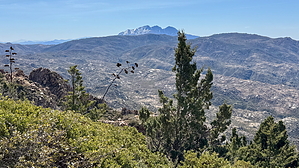
Once reaching the initial crest, great views of Four Peaks and the Superstitions to the south present views that justify the effort to reach this point but the actual high point of Boulder Mountain stands a short distance east where you will find a large cairn and summit register. Getting there might involve fighting some stout manzanita and no obvious use path. It's not technically enjoyable, but it also doesn't last too long. :)

From Round Valley this is close to a 4,000 foot climb, less than 2 miles of which is not on rough 2-track. But not a lot of social influencer types will ever want to do this, which might make it more interesting to others.

Connecting Options
From the high point, you can return the way you came, or you can traverse the full ridgeline (plan on 2-3 hours) across to Forest Road 422 north of Little Pine Flat (which is also part of the Arizona Trail). Heading south will open options with the Ballantine Trail and north will bring you down toward Sunflower on the AZT. The Pipeline Trail and Boulder Bob's Cabin Trail provide possible routes to make long loops (20+ miles).

2025-03-27 chumley


    Check out the Official Route and Triplogs.

    Note
    This is a moderately difficult hike.
    Leave No Trace and +Add a Triplog after your hike to support this local community.
    WARNING! Hiking and outdoor related sports can be dangerous. Be responsible and prepare for the trip. Study the area you are entering and plan accordingly. Dress for the current and unexpected weather changes. Take plenty of water. Never go alone. Make an itinerary with your plan(s), route(s), destination(s) and expected return time. Give your itinerary to trusted family and/or friends.

     Permit $$
    None


     Directions
    or
     Road
    FR / Jeep Road - Car possible when dry

    To hike
    From the Phoenix area, head north on State Route 87 (Beeline Highway) to Forest Road 1704. This is 24 miles from Shea Blvd, and 13.5 miles from the Bush Highway junction. The turn for FR 1704 is just north of the bridge crossing Sycamore Creek between mileposts 212 and 213.

    Cross the creek and navigate the maze of spur roads and dispersed campsites while heading about half a mile east. Park before the road begins the rough, eroded climb up the hill out of Round Valley.

    (Adventurous drivers may wish to drive a portion of the road described in the hike. The condition improves after the first hill climb and making it about a mile and a half wouldn't be awful. After that, it gets worse, and I wouldn't recommend anything other than OHVs attempt to drive more than 2.5 miles.)
    page created by pseudalpine on Mar 27 2025 11:02 am
     90+° 8am - 6pm kills
    helpcorrectionissue

    end of page marker