 Route Editor

| Guide | ♦ | 7 Triplogs | 0 Topics |
details | drive | permit | forecast | 🔥 route |
stats |
photos | triplogs | topics | location |
| 52 | 7 | 0 |
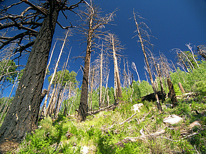
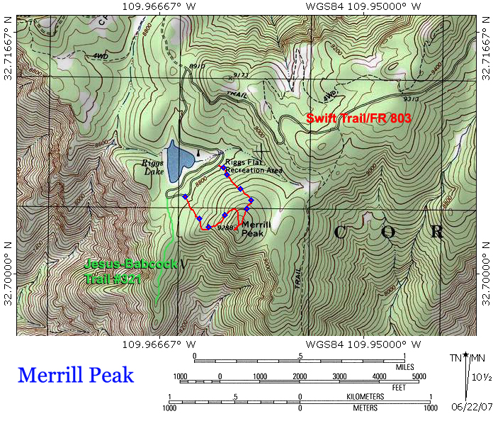
Pinaleno peak-bagging by PrestonSands  Merrill Peak, a 9288-foot peak on the west end of the Pinaleno Mountains, offers incredible views of the Sulphur Springs Valley and most of southern Arizona. Merrill Peak was named for Gerald Merrill, the forest ranger of this area during the early 1900s. This short, off-trail hike from Riggs Lake Campground to the top of the peak is relatively easy and makes for an excellent adventure if you are camping in the Riggs Lake area. Bring a topo map or GPS, and start early to avoid thunderstorms during monsoon season. Merrill Peak, a 9288-foot peak on the west end of the Pinaleno Mountains, offers incredible views of the Sulphur Springs Valley and most of southern Arizona. Merrill Peak was named for Gerald Merrill, the forest ranger of this area during the early 1900s. This short, off-trail hike from Riggs Lake Campground to the top of the peak is relatively easy and makes for an excellent adventure if you are camping in the Riggs Lake area. Bring a topo map or GPS, and start early to avoid thunderstorms during monsoon season.You can begin your hike anywhere in Riggs Lake Campground. If you start at the far west end of the campground, you'll have better views while hiking up, but at the price of scrambling over endless deadfall from the 1996 Clark Peak Fire. There is a shallow drainage near the east end of the campground that provides an easy route to the top. This route begins along the upper campground loop (32.70734 N, 109.96145 W). As you head up this shady, forested drainage, you may notice some carvings in the trees, as evidence others have used this route. When the drainage begins to fade near the top of the mountain, keep heading uphill in a southerly direction. Once you reach the top of the ridge, begin heading southwest, and stay high on the ridge. Grayish skeletons of burnt trees will mark the summit. Sitting in a small mound of granite rocks on Merrill Peak's rocky and lichen-covered summit is a register, placed there by the Sierra Club. This trail-less summit sees a fair amount of visitors. Several rock fins stick out over the peak's steep southwestern face, offering lofty, panoramic views stretching from the Chiricahua Mountains to the Santa Teresa Mountains. Riggs Lake and Blue Jay Peak are visible, though slightly obscured by the burned-out trees.
Check out the Official Route and Triplogs. Leave No Trace and +Add a Triplog after your hike to support this local community. | ||||||||||||||||||||||||||||||||||||||||||||||||||||||||||||||||||||||||||||||||||||||||||||||||||||||||||


