 Route Editor

| Guide | ♦ | 167 Triplogs | 2 Topics |
details | drive | permit | forecast | 🔥 route |
stats |
photos | triplogs | topics | location |
| 1.1k | 167 | 2 |
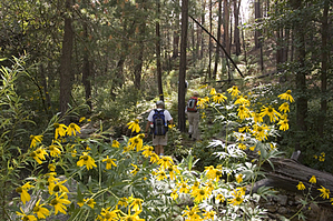
Escape from the Heat by leadhiker  Anyone who has hiked the upper elevations of the Santa Catalina Mountains more than once or twice has probably used The Marshall Gulch Trail to link up with other trails. Many people have picnics by the parking area and use this trail to wander in the woods. It's a great trail to take the grandkids for a little excursion. Sabino Creek is just left of the parking area as it begins its drop into the upper reaches of Sabino Canyon. Anyone who has hiked the upper elevations of the Santa Catalina Mountains more than once or twice has probably used The Marshall Gulch Trail to link up with other trails. Many people have picnics by the parking area and use this trail to wander in the woods. It's a great trail to take the grandkids for a little excursion. Sabino Creek is just left of the parking area as it begins its drop into the upper reaches of Sabino Canyon.Unfortunately, the large Aspen Fire of 2003 severely burned the upper sections of the canyon, and many acres of lush forest were lost. Lack of vegetation eroded the area quite badly. The area is recovering, and the new Aspens are already taller than your average man. The Marshall Gulch Trail #3 climbs from the Marshall Gulch Picnic Area up to Marshall Saddle. The trail is in good condition and relatively easy to follow.
After the short steep stretch initially, the trail enters the wilderness area and contours up Marshall Gulch on its right-hand slope through dense pine/fir forest. The stream almost always has water in it, though it may only be occasional pools in the driest months. Just as you make your first crossing of the creek, a side trail comes in from your left. This is the cut-through trail from behind the restrooms. Put a marker here if you will be coming back this way, as you really don't want to take the cut-off trail. The last time I was up there, there was a lot of deadfall. The trail meanders up the stream bed, crossing back and forth a couple of times. After about 0.5 miles, the trail crosses to the right side of the creek and then heads up, with the stream below you 35 to 50 feet. This area of the trail usually has a lot of ferns and various wildflowers. At about 1.0 miles, the trail makes a sharp left crossing of the creek for the last time. Watch for this crossing as many hikers have gone up the hill straight ahead, and you can mistakenly follow their footsteps. After 1.2 miles, the trail climbs up over some flat rocks and comes to Marshall Saddle. Marshall Saddle is a five-way trail junction for several trails. Aspen Trail #93 takes off to the left and the right (north and south). To the north, it is 1.3 miles and 1000 feet of gain to the top of Radio Ridge. To the south on the Aspen Trail, it is 2.5 miles back to the parking area at the picnic area. Wilderness of Rocks Trail #44, continues straight ahead (west). Mint Spring Trail #20, takes off to the right (northeast) and ends at Carter Canyon Road. Several round trip or loop hikes can be made using the Marshall Gulch Trail as a starting, middle, or finish link. You can make an easy 3.7-mile loop by starting on the Marshall Gulch Trail to Marshall Saddle and then take the Aspen Trail to the left, stopping at "Lunch Ledge", and return to the parking lot. A little harder hike would be to do the same hike clockwise. A good work out hike with a lot of up and downs would be to start at Ski Valley and take Aspen Draw Trail #423 to the top of Radio Ridge, then down the Aspen Trail looping around to the parking area at the Marshall Gulch Picnic Area, up the Marshall Gulch Trail to Marshall Saddle and then back up the Aspen Trail to Radio Ridge and back down to Ski Valley. This is a great 9.2-mile loop with 2950 feet ascending and 2300 feet descending. I like to leave my vehicle in the town of Summerhaven and catch a ride to the Marshall Gulch Trailhead with someone. Then I hike out the Mint Spring or Turkey Run Trails to town and stop at the Pie Shop to reward myself for a nice day of hiking. Two other trails depart from this parking area. Aspen Trail #93 leaves from the southwest corner and climbs gradually in a southerly direction. The Sunset Trail #90 leaves from the southeast corner and stays on the west side of Sabino Creek for about 300 yards, and then crosses the creek on some flat rocks. Check out the Official Route and Triplogs. Leave No Trace and +Add a Triplog after your hike to support this local community. One-Way Notice This hike is listed as One-Way. When hiking several trails on a single "hike", log it with a generic name that describes the hike. Then link the trails traveled, check out the example. | |||||||||||||||||||||||||||||||||||||||||||||||||||||||||||||||||||||||||||||||||||||||||||||||||||||||||||||||||||||||||||||||||||||||||||||||||||||||||||||||||||||||||||||||||||||||||||||||||||||||||||||||||||||||


