 Route Editor

| Guide | ♦ | 23 Triplogs | 1 Topic |
details | drive | permit | forecast | 🔥 route |
stats |
photos | triplogs | topic | location |
| 172 | 23 | 1 |
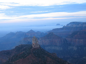
road to recovery by Nan  Watch the sunrise from Point Imperial and stretch your legs on this short but rewarding trail before the long drive from the North Rim back to Phoenix (or other points south)! This is an easy hike through an area of the Kaibab forest recovering from wildfire. Watch the sunrise from Point Imperial and stretch your legs on this short but rewarding trail before the long drive from the North Rim back to Phoenix (or other points south)! This is an easy hike through an area of the Kaibab forest recovering from wildfire.The trail starts at the Point Imperial parking lot and heads north; some maps, like the Falcon Guide, show it as a northerly extension of the Ken Patrick Trail. As the road falls away to the left, you enter the old burn area, now dominated by the towering skeletons of pines and aspens. A stunning variety of pioneer species now thrive in this area ravaged by the 2000 Outlet fire. The trail swings briefly out to the Rim about a mile in and provides a couple of informal viewpoints into Marble Canyon, before turning back inward across the plateau.
This is an easy-going trail, well-maintained, and mostly flat. If you're a flatlander and just hiked out of the Canyon the day before, you might get a bit winded on one of the few gentle hills. There's no summit or other goal here, so turn around when you're ready to go back. Mileage given is to/from the junction with Saddle Mountain Trail, which continues on another few miles to the Nankoweep TH. Grand Canyon NPS Details 4.0 mi. / 6.4 km round-trip; 2 hours approximate round-trip hiking time. This easy trail passes through areas burned by the 2000 Outlet Fire and ends at the north park boundary. From there connections are possible to the Nankoweap Trail and U.S. Forest Service roads. Check out the Official Route and Triplogs. Leave No Trace and +Add a Triplog after your hike to support this local community. One-Way Notice This hike is listed as One-Way. When hiking several trails on a single "hike", log it with a generic name that describes the hike. Then link the trails traveled, check out the example. | |||||||||||||||||||||||||||||||||||||||||||||||||||||||||||||||||||||||||||||||||||||||||||||||||||||||||||||||||||||||||||||||||||||||||||||||||||||||||||||||||||||||||||||||||||||||||||||||


