Upper Sabino Canyon Riparian Area, AZ | HikeArizona
username
X
password
register
for free!
help
 
   🔥

Upper Sabino Canyon Riparian Area, AZ

Guide 25 Triplogs  0 Topics
  3.2 of 5 
Fav
Wish
1
details
drive
permit
forecast
🔥
route  
stats
photos
triplogs
topics
location
72 25 0
Statistics
tap icons for details
Difficulty 0.5 of 5
Route Finding 2 of 5
Distance Round Trip 1.5 miles
Trailhead Elevation 8,335 feet
Elevation Gain -370 feet
Avg Time Round Trip 1 - 1+ hours
Kokopelli Seeds 3.35
feature photo
Photos Viewed All MineFollowing
6  2021-08-31
Aspen Draw Trail #423
PrestonSands
3  2013-09-29 fricknaley
24  2011-05-15 RedRoxx44
6  2010-09-01 sirena
4  2010-07-31
Lemmon Squeezin' Loop
joebartels
8  2010-07-31
Lemmon Squeezin' Loop
MARLIN
15  2010-07-31
Lemmon Squeezin' Loop
juliachaos
18  2010-07-31
Lemmon Squeezin' Loop
The_Eagle
Page 1,  2
Author
author avatar Guides 264
Routes 836
Photos 13,511
Trips 5,431 map ( 27,479 miles )
Age 53 Male Gender
Location
Associated Areas
list map done
Tucson Region
Historical Weather
Trailhead Forecast
Radar Map
Expand Map
Preferred Aug, Sep, Jul, Jun → 9 AM
Seasons   Spring to Autumn
Sun  6:51am - 6:21pm
Official Route
 
1 Alternative
 
 Water
Historic Fire Perimetersacres
🔥 2020 Bighorn Fire119.5k
🔥 2003 Aspen Fire87.7 mi*
🔥 View (All) - over Official Route 🔥
*perimeter length in miles


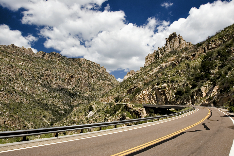
Arizona Screamer
by joebartels

 
Low Down
1.5mi out-n-back hike. Explorers will rejoice in the short-lived glory. Over half the hike is on a service road. Bickering "I refuse to hike a jeep road" wannabe purists should form clubs and grasp their Abby bibles.


Atmosphere
The drive up the Catalina mountain range is Arizona to the bone. Nowhere else in this universe can you drive from a lush saguaro forest to an alpine creek in under an hour. This day was extraordinarily special. Generous summer storms provided the mountains with a surreal feeling. The desert had kick! Pleats in the saguaros go plump plump plump. Ocotillo darted the hills in a game of we got shade, how 'bout you. Police were actually nabbing 100mph+ crotch rockets and letting +5mph seat-belted sedans pass with a tip of the hat and a smile. Southern Arizona pumped out Labor Day weekend invigorated with more energy than a nuclear turbine.

Unfortunately, the pinnacle of desert life is difficult to grasp on film. It must be witnessed in person. When the elements click the experience explodes.


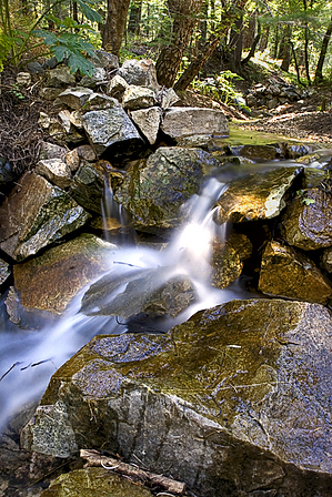
Hike
Directly across from the Iron Door restaurant the hike begins. Squeeze behind the guard rail and you'll see a path. There is no signage. The first few steps might keep you wondering if you're in the right place. Timid thoughts are all but forgotten as the Catalina Alpine Vortex whips out the howdy sign.

Soon you're down at a creek crossing. This is the uppermost part of Sabino Canyon so that'd be Sabino Creek! The creek is fed by numerous seasonal springs in these upper reaches. The first appears to be Kingler Spring which was pumping out volumes on this day. It seemed almost impossible there was so much water. All of this water is somehow coming from that itty bitty slope with the ski run. This mountain must-have high-tech microbeads in its pores!


You could hike all the way to the Seven Falls and back if you brought enough rations. That'd be tough to time with desert canyoneering in the heat and the cool alpine up top. Best make it a shuttle starting at the top in October!

Just across the creek is a junction. Hang left and follow the creek. You are now in the sweet zone. It's sweet but short-lived. Venture over to the creek and work your way in for cascade views. Flora most couldn't fathom exist just fifteen direct miles from downtown Tucson.

The trail soon reaches a service road and the sweet zone ends. It's a nice forest hike to the end of the designated riparian area. Several variations of water storage units are in use or decaying from long ago. It's not uncommon to see plumbing in the forest. Return by the way you came.

Check out the Official Route and Triplogs.

Leave No Trace and +Add a Triplog after your hike to support this local community.

2007-09-03 joebartels
    WARNING! Hiking and outdoor related sports can be dangerous. Be responsible and prepare for the trip. Study the area you are entering and plan accordingly. Dress for the current and unexpected weather changes. Take plenty of water. Never go alone. Make an itinerary with your plan(s), route(s), destination(s) and expected return time. Give your itinerary to trusted family and/or friends.

     Permit $$
    Visit overview & permits.
    2022 - FAQ
    $8 per vehicle per day
    $10 per vehicle per week
    $40 per vehicle per year (valid for one year from date of purchase)

    There are four specific day use areas that require a Coronado Recreational Pass or a National Pass/America the Beautiful Pass.
    1) Sabino Canyon - located on the Santa Catalina Ranger District (520)749-8700
    2) Madera Canyon - located on the Nogales Ranger District (520)281-2296
    3) Cave Creek - located on the Douglas Ranger District (520)364-3468
    4) Mt. Lemmon at 11 day-use sites.

    2022 Catalina State Park
    Per vehicle (1-4 Adults): $7.00
    Individual/bicycle: $3.00

    2022 Sabino Canyon Tram is $15 extra. [ website ]

    Coronado Forest
    MVUMs are rarely necessary to review unless mentioned in the description or directions
    Coronado Motor Vehicle Use Maps (MVUMs)


     Directions
    or
    or
     Road
    Paved - Car Okay

    To hike
    Take Catalina Highway from Tucson to the Mount Lemmon Ski Valley. Park either to the right (un-gated) or the left closer to the ski area facilities (gated, but open until 5 p.m.). Walk along the ski area-side of the highway back the way you came, and duck inside the guardrail as soon as you can, which is about 5-feet from the eastern edge of the ski area-side parking lot. Walk along the trail, which runs just outside of the guardrail on the ski area-side of the road. This section lasts less than 1/10 of a mile and then dips down into the drainage to the right.
    helpcorrectionissue

    end of page marker