This trail connects a ridge between the Desert Classic Trail post #?? and the Guadalupe Ridge. This is a popular trail accessed from the San Gabriel Trailhead.
Residents of the local neighborhood frequent a loop with Beverly Canyon Trail - South via a short jaunt on the National Trail. It's 2.65mi with 750 AEG.
When hiking several trails on a single "hike", log it with a generic name that describes the hike. Then link the trails traveled, check out the example.
WARNING! Hiking and outdoor related sports can be dangerous. Be responsible and prepare for the trip. Study the area you are entering and plan accordingly. Dress for the current and unexpected weather changes. Take plenty of water. Never go alone. Make an itinerary with your plan(s), route(s), destination(s) and expected return time. Give your itinerary to trusted family and/or friends.
Permit $$
no fees or permits reported
if incorrect tell us about it
Directions
Road
Paved - Car Okay
To hike The most popular access is from the San Gabriel Trailhead at San Gabriel Ave and 40th Place.
From I-10 and Elliot, head west on Elliot to 44th Street. Turn right on 44th St and take the second left onto E San Gabriel Ave. Follow Gabriel to 40 Place. There is a right notch or jag in the street but it goes through. Parking is only allowed on the west side (mountain side) of 40th Place. Parking is from 5 am to 8 pm only!
Simply head north passing Western Star. When you pass the house turn right on the Desert Classic Trail and follow a short distance to the noticeable maintenance road going up the ridge.
 Route Editor

 This trail connects a ridge between the Desert Classic Trail post #?? and the Guadalupe Ridge. This is a popular trail accessed from the San Gabriel Trailhead.
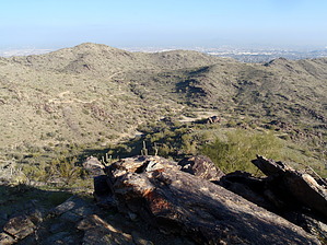


