 Route Editor

| Guide | ♦ | 55 Triplogs | 10 Topics |
details | drive | permit | forecast | 🔥 route |
stats |
photos | triplogs | topics | location |
| 539 | 55 | 10 |
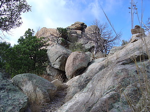
Prickley pear to pine cones! by Jeffshadows  This hike is one that most hikers I know who also grew up in Tucson always have on their "To do" list. It starts on the valley floor and takes you to Ponderosa pine. It also takes you through some of the most spectacular scenery the Catalinas have to offer. Nearly everyone I've ever spoken to about this route had always gone in the opposite direction, that is "From the top, down", or had done the route as an overnighter. I was able to do it in one day without much difficulty, but it is tiring. Here are some general recommendation notes before I get into the route details: This hike is one that most hikers I know who also grew up in Tucson always have on their "To do" list. It starts on the valley floor and takes you to Ponderosa pine. It also takes you through some of the most spectacular scenery the Catalinas have to offer. Nearly everyone I've ever spoken to about this route had always gone in the opposite direction, that is "From the top, down", or had done the route as an overnighter. I was able to do it in one day without much difficulty, but it is tiring. Here are some general recommendation notes before I get into the route details:- Pack as lightly as possible and make sure your load is well-centered; you'll spend a good portion of the trip climbing ridges and switchbacks. - Water was available along the entire route, except for Romero Pass on through to Wilderness of Rock. In Wilderness, there's water nearby so one could leave the trail and find it easily. - Start early and give yourself time to enjoy the scenery! - Wilderness of Rock is readily accessible from the end of Marshall Gulch and provides great scenery for little effort, e.g. - it's usually very busy on weekends. The same goes for the first couple of miles of trail that take you through Romero canyon past the pools - a "natural water park" and popular day hike destination. - I went alone, but I also carry a portable CBHAM radio. There are stretches of this route that are completely isolated and exposed. If the weather is poor or you suffer an injury, you might be a long way from help. Although I did get a cell phone signal at some points, I was never able to send any messages out. - You'll need to be dropped off at Catalina State Park and picked up in Ski Valley, or leave two cars, etc. - It took me just over eight hours to complete the trip making a couple of long stops and on a day when there was zero traffic on the trail. The only other person I've met who took this same route was a gentleman in his 40's who reported it took him nearly ten hours. - There is a fee in Catalina State Park; however, when I told the Ranger at the gate what I was doing he didn't charge me since I wasn't using the park.
This section of the route leaves the trailhead at Catalina State Park and ends at Romero Pass. It is 7.3 miles in length and took roughly four hours with a few stops along the way. The first 2.8 miles of trail to Romero Pools are heavily used and the trail shows the wear. When I arrived at the pools in autumn all of the trees were ablaze with fall colors and the pools and waterfalls were swollen and crystal clear. This was one of the few times I've seen the area deserted. The trail climbs away from the pools and follows the south ridge of the canyon, crossing the stream from time-to-time until it climbs the north wall of the canyon towards a gorge that is visible ahead. The trail is well beaten and large cairns (24'+ tall) have been emplaced at every water crossing. As you climb towards the gorge the trail levels at one or two spots, one includes "Old Trail Camp". The camp sits in a nice grassy area near the stream and includes a copious overhead cover and a fire ring. It would probably be a great camping spot. Continuing away from the camp, the trail climbs the gorge on its way to Romero Pass. The trail follows the stream up the gorge for a ways and there were many down trees on the trail in this area when I went through. It finally begins to break away from the stream and climb steeply up the gorge on a final push to the pass. The switchbacks get shorter and the trail becomes steeper toward the end of the climb until it finally arrives at the pass. Leg#2 - Mount Lemmon Trail #5 The Mount Lemmon trail connects to the Wilderness of Rock trail after 1.9 miles of uphill travel. The trail leaves the junction at the top of the pass heading east. One could leave from this point onto the West Fork trail, as well, and visit Sabino Canyon and the top of the Front Range hikes if one were so inclined. There are excellent views to be had here of the Pusch Ridge Wilderness, Sabino Canyon, and all of the other ranges to the south. The Lemmon trail immediately begins to gain elevation and is fairly rocky and rutted. The trail winds around boulders and climbs through loose rock at numerous points but the challenging terrain is outweighed by the beauty around you. This section of the route was the first time I hadn't seen footprints or poke holes from hiking poles on a trail in years. Judging by the condition of the trail it was safe to assume no one had been on it in weeks. The trail continues to climb sharply until it arrives at a small peak and drops down into the region overlooking Wilderness of Rock. There are magnificent views here, as well. From this point, one can continue on the Lemmon Trail toward the summit or go through Wilderness of Rock. I chose the latter. Leg#3 - Wilderness of Rock Trail #44 The Wilderness of Rock trail connects to the Lemmon Rock Lookout trail after 2.3 miles of beautiful scenery. It winds through a scenic open pine forest studded with large boulders and rock formations. This area is a great place to visit on a short hike from Summerhaven to do some bouldering or short climbs. The route reconnects to the stream here in many places and there are lots of little pools if the season is wet enough. It's easy to slow down in here and enjoy oneself, especially because the grade is marginal after hours of steep climbing. When you come upon the junction with the Lemmon Rock Lookout trail you have the choice of continuing to the summit or following the Wilderness of Rock trail to Marshall Gulch, which will take you to Summerhaven. Leg#4 - Lemmon Rock Trail #12 The Lemmon Rock Lookout trail climbs for two miles out of Wilderness of Rock and up towards the summit of Mount Lemmon. As the trail winds its way up towards Rappel Rock, the forest starts to close back in and the rock formations disappear. Eventually, the trail begins to switchback steeply towards Lemmon Rock Lookout, which is visible (Look for the little cabin near the cliff). After matching elevation with the Lookout, the trail becomes a dirt road and one must continue uphill beyond the signed junction with the Sutherland trail. The trail (now a dirt road) then hits another dirt road which is the Mount Lemmon Trail. Following the Mt. Lemmon trail will take you to the summit, which is another half-mile uphill and marked with a small medallion placed by the USGS. One can then follow the road back down to the parking lot near the electrical substation, or continue (as I did) down past the observatory to Ski Valley. Sure, it's not Everest or Annapurna, but you feel like you accomplished something that day standing at the summit marker. It may be a dubious distinction but it gives you a little smile as you walk into ski valley and hear people complain about how long the drive up the highway was! Gate Policy: If a gate is closed upon arrival, leave it closed after you go through. If it is open, leave it open. Leaving a closed gate open may put cattle in danger. Closing an open gate may cut them off from water. Please be respectful, leave gates as found. The exception is signage on the gate directing you otherwise. Check out the Official Route and Triplogs. Note This is a difficult hike. It would be insane to attempt this entire hike without prior experience hiking. Leave No Trace and +Add a Triplog after your hike to support this local community. | |||||||||||||||||||||||||||||||||||||||||||||||||||||||||||||||||||||||||||||||||||||||||||||||||||||||||||||||||||||||||||


