 Route Editor

| Guide | ♦ | 22 Triplogs | 2 Topics |
details | drive | permit | forecast | 🔥 route |
stats |
photos | triplogs | topics | location |
| 237 | 22 | 2 |
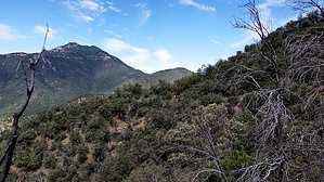
Mingle with soft-eyed deer by HAZ_Hikebot   Temporal Gulch Trail is one of the least traveled routes in the Santa Ritas. That's not because this remote backcountry isn't worth a visit, but because it's more than just a little hard to get in. The north end of the gulch is accessible from Madera Canyon by hiking up the Super Trail or Old Baldy Trail to Josephine Saddle and then contouring around Josephine Peak to the head of the drainage. You can drive to the downhill end of the trail, but that requires winding over dirty roads for a considerable distance and bouncing the last couple of miles up a jeep track that can require a high clearance 4-wheel drive vehicle. However, those who go to the trouble generally find that the reward is well worth the effort. Temporal Gulch Trail is one of the least traveled routes in the Santa Ritas. That's not because this remote backcountry isn't worth a visit, but because it's more than just a little hard to get in. The north end of the gulch is accessible from Madera Canyon by hiking up the Super Trail or Old Baldy Trail to Josephine Saddle and then contouring around Josephine Peak to the head of the drainage. You can drive to the downhill end of the trail, but that requires winding over dirty roads for a considerable distance and bouncing the last couple of miles up a jeep track that can require a high clearance 4-wheel drive vehicle. However, those who go to the trouble generally find that the reward is well worth the effort.Temporal Gulch Trail wanders up a broad canyon along a picturesque little stream punctuated with stepping stone crossings and a bubbly waterfall (when it has water in it). When it doesn't, the riparian area is still a pleasant place to be, shaded by spreading sycamores and other desert canyon species clustered along the streambed. Other desert dwellers congregate here, too. Increase encounters by proceeding quietly and watchfully. Colorful songbirds flash through the trees, and soft-eyed deer browse in the grasses and brush, sometimes scarcely taking notice of you.
Temporal Gulch Trail extends between the mouth of the gulch and Josephine Saddle, where it intersects several other Santa Rita trails. One possibility for a loop trip is to take the trail to the saddle and then pick one of several routes up, around, or over Mt. Wrightson to Gardner Trail, which leads to the Walker Basin Trail and back to your vehicle. 5.4-miles of this trail are within the Mt. Wrightson Wilderness. No Mechanized vehicles allowed, including mountain bikes, are permitted in Wilderness areas. Check out the Official Route and Triplogs. Leave No Trace and +Add a Triplog after your hike to support this local community. One-Way Notice This hike is listed as One-Way. When hiking several trails on a single "hike", log it with a generic name that describes the hike. Then link the trails traveled, check out the example. | ||||||||||||||||||||||||||||||||||||||||||||||||||||||||||||||||||||||||||||||||||||||||||||||||||||||||||||||||||||||||||||||||||||||||||||||||||||||||||||||||||||||||||||||||||||||||||||||||||||||


