Route Editor

| Guide | ♦ | 24 Triplogs | 0 Topics |
details | drive | permit | forecast | 🔥 route |
stats |
photos | triplogs | topics | location |
| 141 | 24 | 0 |
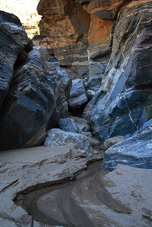
The Highway's First Treasure by fricknaley  Anyone who's ever gone up the Catalina Highway will be familiar with the first hard-right you make as soon as you get to the mountains. There is a beautiful canyon that rumbles down on you from the northwest, forcing that characteristic turn. I've always wondered what the heck was up there, and after hiking the Soldier Trail, I realized it led to Soldier Canyon. Now I knew there was some sweetness hiding in the canyon...Time to go look at it. Anyone who's ever gone up the Catalina Highway will be familiar with the first hard-right you make as soon as you get to the mountains. There is a beautiful canyon that rumbles down on you from the northwest, forcing that characteristic turn. I've always wondered what the heck was up there, and after hiking the Soldier Trail, I realized it led to Soldier Canyon. Now I knew there was some sweetness hiding in the canyon...Time to go look at it.This is a total canyon bushwhack with no trail whatsoever, so be prepared for some climbing and fighting, or this may not be the hike for you.
At about 1 mile, a narrow, rough side canyon comes feeding in from the right. You can see a rugged pile of massive boulders to your left that seems to be blocking your way up the main canyon. You do need to make the left and stay in the main canyon. Though it seems impossible, you can climb up the left side of this mess. It's a rough scramble, but there is a way. Eventually, the tiniest use path dumps you in underneath the rocks. A very narrow, knifelike rock leads you up about 8 feet or so, and then you are free. It seems this is the only way up, and if you start right and exhaust all your options until you are on the left side of the pile, you will find it. Be careful here. A fall would be BAD. Climb up more piles until the canyon levels out a bit. From here, it is about 0.7 miles or so of more easy canyon climbing and creek crossing until the canyon ends at a vertical wall. There are two beautiful thin falls here. One in front that is two-tiered, and a second multitiered fall further back to the left. This area is just peaceful and wonderfully secluded—worth the trip, to be sure. Head back the way you came, as much as you can anywhere, and watch that footing. The total climb is a little over 1240 feet and extremely rugged. Check out the Official Route and Triplogs. Leave No Trace and +Add a Triplog after your hike to support this local community. | ||||||||||||||||||||||||||||||||||||||||||||||||||||||||||||||||||||||||||||||||||||||||||||||||||||||||||||