 Route Editor

| Guide | ♦ | 9 Triplogs | 1 Topic |
details | drive | permit | forecast | 🔥 route |
stats |
photos | triplogs | topic | location |
| 121 | 9 | 1 |
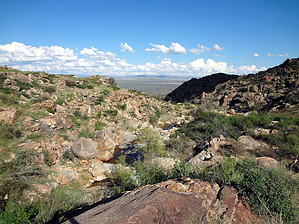
it might make you cry by joebartels  Overview OverviewA rarely used trail that travels from FR 684 to FR 697 where Senator Highway (FR 52) ends. It follows the Castle Creek drainage in the Castle Creek Wilderness. Trivia Hundreds if not thousands admire this trail daily from Sunset Point Rest Stop on I-17.
A carsonite post marks the beginning of the trail. In late September it was quickly camouflaged by tall green grass. The course is questionable at times. Follow the cairns. They are easier to spot when the grass is low. A GPS route loaded into a GPS device will make it easier to follow if you know how to use the device. According to topo "Castle Creek Cabin" is only a few paces north of the trailhead. Judging by satellite view all that remains is a corral or possibly a foundation. At 1.35 mi you enter the Castle Creek Wilderness. There is a four-post square sign(2013), (2018, new steel signs). Twin Peaks Trail #240 heads north. It was among the worst catclaw adventures of my life in 2010. It appeared no different 3 years later, perhaps worse if that is possible. Our trail continues west another 4.7 miles to Senator Hwy. The lower portions are predominantly catclaw with low lying chaparral such as shrub live oak. It can be irritating at times. Remember to look up and around. The surrounding mountain views are impressive. From midway to the top look back to the east in the I-17 corridor. You can make out Black Mesa (near side) and Perry Mesa separated by a canyon which is the Agua Fria River. Fauna is on display for those with a sharp eye. We spotted a ring-necked snake, one gopher snake, a mild neurotoxin gila monster, one or two large ear mule deer and even a Jerusalem cricket. Aside from a quarter-mile at the end in the pines, this trail is exposed. There are a few dead to gnarly looking white oaks ( or similar ) midway up that provide nice shade for a break. So far you have been traveling through what seems like rolling hills. Sporadic pines on a ridge will come into distant view. Due west is where you are going. At 3.75mi you cross the last creekbed which is the uppermost tributary for Castle Creek. 3.75 mi to 5.2 mi is a series of switchbacks. Route finding becomes easier due to thicker vegetation. The pines up top will be most welcome. Aside from shade and cooler temps, the trail is open and wide. A loop with the Twin Peaks Trail is possible. The catclaw can be brutal. Camping Nice inviting areas around the upper trailhead. Personally, I wouldn't be camping on this trail unless in a pinch. I didn't notice any well-used spots. Water Pools in Castle Creek after recent rains. Check out the Official Route and Triplogs. Leave No Trace and +Add a Triplog after your hike to support this local community. One-Way Notice This hike is listed as One-Way. When hiking several trails on a single "hike", log it with a generic name that describes the hike. Then link the trails traveled, check out the example. | ||||||||||||||||||||||||||||||||||||||||||||||||||||||||||||||||||||||||||||||||||||||||||||||||||||||||||||||||||||||||||||||||||||||||||||||||||||||||||||||||||||||||||


