Route Editor

| Guide | ♦ | 16 Triplogs | 1 Topic |
details | drive | permit | forecast | 🔥 route |
stats |
photos | triplogs | topic | location |
| 88 | 16 | 1 |
Canyons are inherently risky. Flash floods occur without notice on sunny days. Technical skills & surrounding topography knowledge required yet does not eliminate risk.
I call it my own by joebartels  Woods Canyon spans over 20 miles from end to end. According to USGS topographical maps, it originates somewhere between Fair & Gash Mountain or possibly Brollier Park. The most exciting part is where it rips into mother earth near 1-17 then heads down towards the Village of Oak Creek. In planning a full canyon hike, it's critical to know the facts. What you see isn't what you get. As mentioned, this canyon becomes noticeable at I-17, just after mile marker 316. A bridge spans what looks to be the origins. This isn't the whole story. Woods Canyon has a 6-7 mile head before even crossing I-17. With maps, I estimate 50-60 square miles of land drains into Woods Canyon before crossing I-17. The point being there's enough landmass to create a serious catastrophe in the narrows. I could have just forewarned, but I wanted you to know firsthand what the warning is all about. If you sprain an ankle in the wrong place and time on this hike, you are dead. Woods Canyon spans over 20 miles from end to end. According to USGS topographical maps, it originates somewhere between Fair & Gash Mountain or possibly Brollier Park. The most exciting part is where it rips into mother earth near 1-17 then heads down towards the Village of Oak Creek. In planning a full canyon hike, it's critical to know the facts. What you see isn't what you get. As mentioned, this canyon becomes noticeable at I-17, just after mile marker 316. A bridge spans what looks to be the origins. This isn't the whole story. Woods Canyon has a 6-7 mile head before even crossing I-17. With maps, I estimate 50-60 square miles of land drains into Woods Canyon before crossing I-17. The point being there's enough landmass to create a serious catastrophe in the narrows. I could have just forewarned, but I wanted you to know firsthand what the warning is all about. If you sprain an ankle in the wrong place and time on this hike, you are dead.This is part of a 3 set series. See the table down below text.
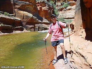
See Woods Canyon (Upper) for the beginning of this hike. Hike I pick up at the scramble & the Supai pool that requires a jump. Since there may be unseen boulders just below the surface, jumping isn't wise. Keep in mind a flood may wash boulders in the pool. Therefore forget it when somebody reports it's okay. Choose wisely and scramble the left bank. A sketchy use-trail leads the way through desert vegetation. Soon you're back down on the canyon floor. I don't believe others share my enthusiasm, but the next 0.8 mile is my favorite! Welcome to the motherload of quality curvaceous Grade-A Sedona-Supai Red-Rock. The "cow pies" of Mitten Ridge are bigger, but they don't hold strength when it comes to curves! Nothing compares to the waves before the scramble but you won't be disappointed! The sandstone floor loses direction. It's blobbed like slow-melting swiss cheese. Followed shortly by the coconino dunes, a thin layer of Coconino capping the Supai! This leads to a slight crescent pool that's been fighting a curve in the canyon for millions of years. The canyon is winning by a ledge! As noted the pool digs deeper and away from the wall. Swimming would be an honor in this beauty, but it is possible to skirt the edge. Further down comes a site that is rarely seen. The Sinaguan Indian ruins of Woods Canyon! Spectacular is an understatement for these 800-year-old dwellings. The ruins themselves are small. The setting is a Supai dream right down to the dryfall adjacent left. You may be thinking of doing an "upper out-n-back" to the ruins. It's possible. It's also possible you'll cramp up so hard on the return you'll never see the next day of your life. Another bend, another perk, dang Woods packs a punch! Imagine a 300 ft slab of crisp jewelers-cut Coconino Sandstone that'll give Long Canyon a run for its money. Dreams come true in Woods! If you've made it this far, you're more or less committed to the "full canyon offering" for a day hike. Now for the bad news, the perks, for the most part, are behind you. Next come miles and miles of mini boulders. I'm serious, OVER five miles of mini boulder hopping. You'll swear it never ends. Red Rock Beach, as mentioned in "Woods Canyon (Lower)", is your focus and goal for the next few hours of your life. Once there, you can't miss the trail leading you out of the canyon and home. But we aren't there yet! Push hard for a couple of hours, and it'll pass quickly. Think about the calves of steel you'll be flaunting next week! Hope arrives with the Supai Freeway. Keep an eye out for Sinaguan Semis with faulty brakes. You may want to stop at the Red Rock Lounge. However, I'd push on past another stretch of boulders which are simply large stones at this point. Better known as ankle busters since your body outweighs the rock. Pass up Red Palette Beach too. Then take a breather at the etched slab. Here you'll find pools deeper & clearer than the previous. It's a great spot to cool off and water up. Tackle another good size stretch of ultra-mini boulders. Keep an eye out on the right bank for cairns. If you're lucky, you'll catch a 1.5-mile trail that high banks the right/west side to Red Rock Beach. The trail goes up at a reasonable slant. Suppose you miss the trail, scratch out 5 miles of boulders and write in 6.5 miles. Not to mention the canyon gets densely populated with sycamores to slow things up. From Red Rock Beach, it's only 3.4 miles home. By the way, don't get excited about Red Rock Beach itself; it's popular from the lower end only because it's the first appearance of ledged Supai. See Woods Canyon (Lower) for the remainder of this hike. For the record, we started this hike in 43-degree weather in late June. The first pool was 59 degrees. I believe the second usually runs 5-8 degrees cooler, but I didn't check this time. I wouldn't recommend bringing a dog in as there's very little solid ground. Camping options are plentiful throughout, but it simply isn't wise. According to statistics, a big storm hits this area nearly every three years. These are freak storms folks, not forecasted. Thanks to Pfredricks, ArizonaHeat & CactusCat for a memorable trek! For now, I rejoice in post-AZventure adrenaline. I imagine in 40-50 years, I'll barely be able to squeak out a trek from the lower trailhead to Red Rock Beach. Guarantee this; the legend will only grow. I'll be babbling about the first time we ran from countless bears and wrestled cougars on route.
Check out the Official Route and Triplogs. Leave No Trace and +Add a Triplog after your canyon trip to support this local community. | ||||||||||||||||||||||||||||||||||||||||||||||||||||||||||||||||||||||||||||||||||||||||||||||||||||||||||||||||||||||||||||||||||||||||||||||||||||||||||||||||||||||||||||||||||||||||||||||||||||||||||||||||||||||||||||||||||||