Mount Ian, AZ | HikeArizona
username
X
password
register
for free!
help
   🔥

Mount Ian, AZ

Guide 16 Triplogs  0 Topics
  4.3 of 5 
Fav
Wish
2
details
drive
permit
forecast
🔥
route  
stats
photos
triplogs
topics
location
181 16 0
Statistics
tap icons for details
Difficulty 4 of 5
Route Finding 2 of 5
Distance Round Trip 9.6 miles
Trailhead Elevation 5,463 feet
Elevation Gain 3,700 feet
Accumulated Gain 3,720 feet
Avg Time Round Trip 5-6 hours
Kokopelli Seeds 28.2
 Interest Off-Trail Hiking & Peak
 Backpack Possible & Connecting
feature photo
Photos Viewed All MineFollowing
Inaugural Calculation on Button Tap!
1  2022-04-23
Mount Wrightson - Mount Ian
DixieFlyer
12  2022-02-12 Jim_H
7  2020-08-06
Santa Rita Crest Loop
LJW
7  2019-11-17
Wrightson-Florida Peak loop
LindaAnn
10  2019-10-17
Santa Rita Crest Loop
LJW
6  2014-07-26
Santa Rita Peaks
Pivo
9  2012-10-13
Mount Ian Loop
cindyl
6  2012-06-23
Old Baldy - Super Trail Loop
JuanJaimeiii
Page 1,  2
Author
author avatar Guides 2
Routes 4
Photos 3,873
Trips 362 map ( 3,964 miles )
Age 49 Female Gender
Location Tucson, AZ
Associated Areas
list map done
Tucson Region
Historical Weather
Trailhead Forecast
Radar Map
Expand Map
Preferred May, Sep, Oct, Aug
Seasons   Spring to Autumn
Sun  6:40am - 6:28pm
Official Route
 
4 Alternative
 
 Water
Historic Fire Perimeteracres
🔥 2005 Florida Fire23.2k


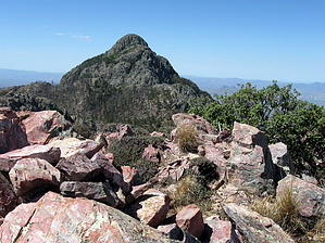
Wonderful Wrightson View
by sirena

Overview
Most people hit the Santa Ritas to bag Mt. Wrightson, the highest peak in the range. This hike will take you to the highest point on the Santa Rita Crest at 9146 ft. The elevation gain from Madera Canyon is similar to Mt. Wrightson, but with a bit of off-trail route-finding, ending with one of the most spectacular views of Wrightson itself.


Hike
Please refer to the trail descriptions on this site for either the Old Baldy or Super Trail to get yourself to Baldy Saddle at 8750 ft. (trail stats above are from the Old Baldy Tr.) From Baldy Saddle, take the Crest Trail north, climbing away from Mt. Wrightson. At 0.5 miles from the saddle, the trail ends its climb and turns a corner. There is a small grove of aspen in the area, and the trail descends a little. From this point, bushwhack up the slope to your left to attain the small saddle on the ridgeline. Several cairns lead the way, but if you don't find them, just get to the top of the ridgeline as best as you can. Once you reach the ridgeline, turn left and follow the colorful, rocky top northwest toward the summit (about 0.5 miles). There will be a small notch with a tree in it right before the final scramble to the summit. Either scramble right out of the notch or look to the right to find a natural switchback in the rock that leads to the colorful summit cairn. The views of Mt. Wrightson and the surrounding area from Mt. Ian are incredible, and unlike Wrightson, you probably won't have to share them with anyone else. You could also approach Mt. Ian coming from Florida Saddle on the Crest Trail. In that case, look for a cairn on the trail just before you top out on the final climb up to the ridgeline before descending to Baldy Saddle. Mt. Ian is great either as a destination or as part of a longer backpack in the beautiful Santa Rita high country. Or, if you find yourself with some steam left in your legs after summiting Wrightson, this would be a great way to add on some additional 2 miles/400 ft. elevation gain and scenery.

Water Sources
Bellows Spring on the Old Baldy Trail

Check out the Official Route and Triplogs.

Note
This is a moderately difficult hike.

Leave No Trace and +Add a Triplog after your hike to support this local community.

2010-07-09 sirena
    WARNING! Hiking and outdoor related sports can be dangerous. Be responsible and prepare for the trip. Study the area you are entering and plan accordingly. Dress for the current and unexpected weather changes. Take plenty of water. Never go alone. Make an itinerary with your plan(s), route(s), destination(s) and expected return time. Give your itinerary to trusted family and/or friends.

     Permit $$
    Visit overview & permits.
    2022 - FAQ
    $8 per vehicle per day
    $10 per vehicle per week
    $40 per vehicle per year (valid for one year from date of purchase)

    There are four specific day use areas that require a Coronado Recreational Pass or a National Pass/America the Beautiful Pass.
    1) Sabino Canyon - located on the Santa Catalina Ranger District (520)749-8700
    2) Madera Canyon - located on the Nogales Ranger District (520)281-2296
    3) Cave Creek - located on the Douglas Ranger District (520)364-3468
    4) Mt. Lemmon at 11 day-use sites.

    2022 Catalina State Park
    Per vehicle (1-4 Adults): $7.00
    Individual/bicycle: $3.00

    2022 Sabino Canyon Tram is $15 extra. [ website ]

    Coronado Forest
    MVUMs are rarely necessary to review unless mentioned in the description or directions
    Coronado Motor Vehicle Use Maps (MVUMs)


     Directions
    or
    or
     Road
    Paved - Car Okay

    To Madera Canyon Trailhead
    From Tucson: I-19 south to exit 63 Continental. At the end of the exit take a left and follow brown signs to Madera Canyon. You'll be taking White House Canyon Road 13.2 miles to Madera Canyon.

    From PHX (I-10 & AZ-51) 152 mi - about 2 hours 31 mins
    From TUC (Jct 1-10 & Grant) 42.3 mi - about 55 mins
    From FLG (Jct I-17 & I-40) 295 mi - about 4 hours 37 mins
    page created by sirena on Jul 09 2010 10:53 am
    helpcorrectionissue

    end of page marker