Pipeline Trail starts about 0.4 miles in on the Mount Wrightson Super Trail. There is no signed trail marker at the Pipeline Trail junction with the Mount Wrightson Super Trail. The Super Trail will climb out of the creek it has been following and head in a northwest direction. When it switches to an easterly direction, start looking for a trail that heads up the hill to your left. The Pipeline Trail climbs about 200 feet and then levels off. The Pipeline Trail is now in the next canyon north of the one you just climbed out. This is the creek that comes from Kent and Sylvester Springs. The trail continues for about a half-mile and then comes to a junction with the Kent Spring Trail. The Kent Spring Trail comes in from the north and continues downstream, and the Pipeline Trail continues up this steam. The Pipeline Trail follows the stream for about 0.6 miles before climbing up and Connecting with the Super Trail again.
I have never been to it but Roger's Rock is along this trail. At about 0.9 miles in, the hill to the east of the trail is where Roger's Rock is. At the time I was on this trail (October), the streams were flowing pretty good. I would expect them to dry up in late Spring early Summer until the monsoons. When hiking along the Pipeline Trail, keep an eye out for the pipeline for which this trail is named.
This trail makes an excellent connecting trail for loop hikes involving Kent Spring Trail, Bog spring Trail, and Four Springs Trail. Even though it isn't marked, it was reasonably easy to follow.
When hiking several trails on a single "hike", log it with a generic name that describes the hike. Then link the trails traveled, check out the example.
WARNING! Hiking and outdoor related sports can be dangerous. Be responsible and prepare for the trip. Study the area you are entering and plan accordingly. Dress for the current and unexpected weather changes. Take plenty of water. Never go alone. Make an itinerary with your plan(s), route(s), destination(s) and expected return time. Give your itinerary to trusted family and/or friends.
Four specific day-use areas require a Coronado Recreational Pass or a National Pass/America the Beautiful Pass.
1) Sabino Canyon - located on the Santa Catalina Ranger District (520)749-8700
2) Madera Canyon - located on the Nogales Ranger District (520)281-2296
3) Cave Creek - located on the Douglas Ranger District (520)364-3468
4) Mt. Lemmon at 11 day-use sites.
2025Catalina State Park
Per vehicle (1 person): $10.00
Per vehicle (2-4 people): $20.00
Individual/bicycle: $5.00
Coronado Forest MVUMs are rarely necessary to review unless mentioned in the description or directions Coronado Motor Vehicle Use Maps (MVUMs)
Directions
Road
Paved - Car Okay
To Madera Canyon Trailhead From Tucson: I-19 south to exit 63 Continental. At the end of the exit take a left and follow brown signs to Madera Canyon. You'll be taking White House Canyon Road 13.2 miles to Madera Canyon.
From PHX (I-10 & AZ-51) 152 mi - about 2 hours 31 mins From TUC (Jct 1-10 & Grant) 42.3 mi - about 55 mins From FLG (Jct I-17 & I-40) 295 mi - about 4 hours 37 mins
 Route Editor


 Pipeline Trail starts about 0.4 miles in on the Mount Wrightson Super Trail. There is no signed trail marker at the Pipeline Trail junction with the Mount Wrightson Super Trail. The Super Trail will climb out of the creek it has been following and head in a northwest direction. When it switches to an easterly direction, start looking for a trail that heads up the hill to your left. The Pipeline Trail climbs about 200 feet and then levels off. The Pipeline Trail is now in the next canyon north of the one you just climbed out. This is the creek that comes from Kent and Sylvester Springs. The trail continues for about a half-mile and then comes to a junction with the Kent Spring Trail. The Kent Spring Trail comes in from the north and continues downstream, and the Pipeline Trail continues up this steam. The Pipeline Trail follows the stream for about 0.6 miles before climbing up and Connecting with the Super Trail again.
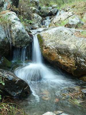


