Route Editor

| Guide | ♦ | 25 Triplogs | 0 Topics |
details | drive | permit | forecast | route |
stats |
photos | triplogs | topics | location |
| 127 | 25 | 0 |
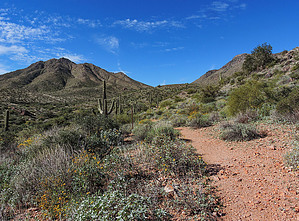
A lower volume Mcdowell's loop by MJNelson  Prologue PrologueIf you are looking for another option to the overcrowded 9+ mile Windgate Bell Loop in the McDowells without the company of over-perfumed and underdressed trophy wives and their dis-attached, self-absorbed and aloof mountain biker husbands, this may be the better option for you. Access Get to Palisades Blvd in Fountain Hills from either Saguaro on the BeeLine or Shea from the 101. Take Golden Eagle Blvd at FH HS all the way to the end. Just before you hit the guard shack at a well-gated community, find your secure parking spot at a large paved lot on the left. Nice restrooms are available at the complex. Make your way across the street and follow the "feather" icons marked on the sidewalk as you stroll 0.6 miles through the neighborhood to the Dixie Mine trailhead maintained by Maricopa County's McDowell Mountain Park. A lockbox at the park line prompt's for a $2.00 entrance fee.
Follow Dixie Mine Trail (1.9 miles) as it intersects with the Thompson Peak Jeep trail and continues to the right up past the mine a short distance. A small sign on the left indicates the trail separating again from the maintenance road. Continue on Dixie Mine Rd as it works its way up, east, and into the vast flat plateau of McDowell Mountain Park. Eventually, you will come to a sign indicating you have reached the junction with Coachwhip Trail. Take CW to the left and continue for 0.8 miles to the intersection with the Windmill Trail. Signage and a park bench await you at the intersection. Take Windmill to the left again and into Scottsdale's Sonoran Reserve and continue until you reach the intersection with Windgate and Bell Pass Trails while admiring the massive bouldered area that houses the Tom's Thumb complex high above on your right. Make the left again into Bell Pass Trailhead. Head uphill for a short while until you come to the well-marked intersection with the Prospector Trail on your left. Take the left onto Prospector until you rejoin Thompson Peak Jeep Road again. Make the left onto the jeep trail for a short distance until you come back to Dixie Mine Rd again. (Thus completing your loop) Take Dixie Mine right, back the way you came into Fountain Hills, and complete the hike. Check out the Official Route and Triplogs. Leave No Trace and +Add a Triplog after your hike to support this local community. | ||||||||||||||||||||||||||||||||||||||||||||||||||||||||||||||||||||||||||||||||||