 Route Editor

| Guide | ♦ | 80 Triplogs | 0 Topics |
details | drive | no permit | forecast | route |
stats |
photos | triplogs | topics | location |
| 287 | 80 | 0 |
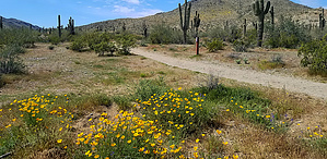
what's that flower you have on by joebartels  History HistoryMax Delta Trail is named for the mine near the west end of the trail. Production years 1913-1942. 500-foot deep shaft, about 2,500 feet of tunnels. It yielded more than 6,200 oz of gold and 4,300 oz of silver. Overview Hills > flats > washes Start at South Mountain Park Main Entrance lot across from Scorpion Gulch. The trail ends at Bajada Trail.
Scorpion Gulch Trading post built in 1936. Owned and operated by William Lunsford and his wife. They lived in the attached building. "Grandpa," as he was known, cared more about children visitors than profit margins. Bottles of pop and penny candy were often given away. In the '60s, parents were known to phone ahead kids were on their way. Bill then returned a courtesy call as they departed the curio shop, which included jewelry, leather goods, and native crafted items. In the 1970s, it became a bar. Scorpion Gulch was listed on the historic preservation register in October of 1990. Hike From the East After a quick left, it follows an old road grade. Then narrows down to a three-foot-wide path passing the entrance Gate House. Brittlebush, Coulter's Lupine, creosote, Yellow Paloverdes and sunshine greeted my adventure on the horizon. Ascending the first hill, views to your right are downtown Phoenix with the current Diamondbacks stadium. Pop, pop, pop gunfire is from the police academy over the north ridge. Whereas artillery noise is likely from Maryvale Circle Ks or Dennys. Tread is excellent throughout. It can get a little noisy at times since the trail follows above the road through the park. On the same token, you get lovely views of the park from the elevated point of view. Passing the park headquarters shares a proportion of the Nature Trail. You get bonus plaques and a bench that looks as sturdy as termites holding hands. 0.1 mi after the bench, take the signed left down into the basin flats. Soon you cross the road to Little & Big ramadas. Hiking through the basin is semi blah. Spring flowers give it life. It was probably pretty cool at one time. Now the saguaro forest shows major signs of being abused by rock throwers. Then you have some free piles of horse apples. With a positive attitude, the right weather in the right light, and enough stress in life, it eases tension. The last half mile is relaxing low-grade hills. I'm not a jogger. I'm not a piece of bacon either. With the skillet heating up, it jogged itself. Synopsis Parts were much better than anticipated. The eastern 1.25 mi and western 0.4 mi were my favorites. Urban noise and rolly hill haters should choose a different trail.
Check out the Official Route and Triplogs. Leave No Trace and +Add a Triplog after your hike to support this local community. One-Way Notice This hike is listed as One-Way. When hiking several trails on a single "hike", log it with a generic name that describes the hike. Then link the trails traveled, check out the example. | ||||||||||||||||||||||||||||||||||||||||||||||||||||||||||||||||||||||||||||||||||||||||||||||||||||||||||||||||||||||||||||||||||||||||||||||||||||||||||||||||||||||||


