This hike follows the Wind Cave Trail as far as Wind Cave, at which time you continue on past the sign warning the trail past that point is not maintained. For more details of the trip up as far as Wind Cave view the Wind Cave page.
Once past the warning sign, you will first pass an area of sharp reddish rocks. Due to the trail not being "maintained" past this point by park personnel, you may find several places where other hikers made their own way. In general, it's better to follow the painted arrows but my directions (and GPS track) will skip an out-of-the-way loop for a more direct route. Passing the red rock area the trail drops slightly through an eroded section for a short distance before rising back up and continuing south along the western traverse of Pass Mountain. When you have traveled about 500' past the warning sign back at Wind Cave, you will pass the Paloverde tree on your left, which is where you will turn left and start climbing, first by walking being careful of the loose rock, then climbing hand-over-hand about 6' up. At first glance, this section may give pause, but the rock is jagged enough with hand and footholds it easy enough. Once up that short climb, you will continue to your left again, now in a northerly direction. After steadily gaining elevation after about 250' you be almost directly above Wind Cave, at which time the trail will wind upward and to the right a couple of times so you will be facing south as you climb some rocky steps. Immediately after the steps you will swing left 180 degrees and continue climbing toward the east. If you look back over your left shoulder (to the northwest) toward Fountain Hills and it's within 15 minutes after the hour, you may see the two-hundred-foot fountain in action. After steadily climbing about 450' you will come to a saddle. At this point, you will encounter some great views, but don't stop here... the views are much better at the summit! From this point on it's just a matter of taking your time to step up one rock after another, wind around some large ones, and after about moving 350' southward you will reach the summit. Congratulations!
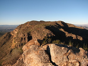
Now it's time to drop your pack and pull out the camera. If you swing around clockwise to take in the whole panorama, starting from the view almost straight north alongside Pass Mountain itself where you can barely see Mt Peeley, next to the right is Mt Ord, then to the northeast come Four Peaks, east is the Goldfield Mountains, slightly southeast is the Superstition Mountains and Apache Junction, south you can look over East Mesa out to the San Tan Mountains. Continue clockwise to take in the South Mountain range, over central Phoenix, Papago Buttes, Camelback Mountain, Piestewa Peak, and the North Mountain range, the McDowell Mountains past Fountain Hills and you've just taken in a vast area of trails just waiting for you to hike.
Once you've taken in your fill of the scenery, eaten your lunch, taken your break (nap?) you simply retrace your footsteps the way you came. If you didn't stop at Wind Cave on the way up, it may be a good time to give your knees a break and stop for a quick break before heading back to the trailhead.
Be sure to stop and visit the Nature Center if you didn't on the way in, it's well worth the stop. The new (Spring 2010) Nature Center has tons of information about the park, wildlife, flora, fauna, books, T-shirts, and such to buy, as well as animal & snake displays.
WARNING! Hiking and outdoor related sports can be dangerous. Be responsible and prepare for the trip. Study the area you are entering and plan accordingly. Dress for the current and unexpected weather changes. Take plenty of water. Never go alone. Make an itinerary with your plan(s), route(s), destination(s) and expected return time. Give your itinerary to trusted family and/or friends.
To Usery Wind Cave Trailhead Directions to Usery Park: From the west on the 202 (Red Mountain Freeway) continue on PAST the FIRST McKellips exit ~10 mi, past Power Rd and take the SECOND McKellips exit. At the top continue on to your left around the round-about over the 202 and continue east on McKellips Rd. About 3 miles east of the 202 you come to Ellsworth Rd. Turn LEFT on Ellsworth and go north about 2 miles, turning right into Usery Mountain Regional Park just past the sign.
From the south on the 202, take the McKellips exit and head east, continuing to Ellsworth as above.
From the west on US 60 take the Ellsworth exit and head north on Ellsworth which eventually becomes Usery Pass Road north of McKellips. Continue past McKellips about 2 miles, turning right into Usery Mountain Regional Park just past the sign.
Directions to the Wind Cave trail head: Once in the park, continue on past the new (Spring 2010) Nature Center building to the information/entrance building where you either purchase a one-day pass or purchase an annual pass (good in all Maricopa Parks except Lake Pleasant) for seniors. If it's your first visit, be sure to ask for a map including information of the all 29 miles of trails in the park. After setting your pass receipt on your dash, continue on the road as it curves around toward the east. Continue past the four-way intersection until Wind Cave Drive on your left. Turn up the drive and follow it until you find a suitable parking place. If it's busy just continue on around the one-way loop until you find an empty spot along the road. The trail head itself is immediately to your right when looking at the Wind Cave facilities building.
Alternate Longer Access: For $2 per-person access turn right (east) off Ellsworth Road at McKellips road and drive about a mile until it ends at Crismon Rd. There is a parking on the SW corner. Entrance to the park is on the NE corner, there are maps and a payment box. The trail that heads north is loose and hard to walk, go east 1/2 mile to trail then head north 1 mile to horse staging area. Starting from this point adds about 5 miles to your round-trip hike to the Wind Cave Trailhead. Also about 150 feet in gain.
From PHX (I-10 & AZ-51) 34.8 mi - about 43 mins (up to 1 hour 10 mins in traffic) From TUC (Jct 1-10 & Grant) 128 mi - about 2 hours 0 mins From FLG (Jct I-17 & I-40) 173 mi - about 2 hours 45 mins
page created by CannondaleKid on Jan 03 2011 3:16 pm
 Route Editor


 This hike follows the Wind Cave Trail as far as Wind Cave, at which time you continue on past the sign warning the trail past that point is not maintained. For more details of the trip up as far as Wind Cave view the Wind Cave page.