 Route Editor

| Guide | ♦ | 8 Triplogs | 0 Topics |
details | drive | permit | forecast | route |
stats |
photos | triplogs | topics | location |
| 21 | 8 | 0 |
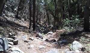
Idyllic Canyon by HAZ_Hikebot   There are extensive mine diggings at the mouth of this canyon, which slices the western slopes of the Huachuca Mountains. The trail starts at the Wilderness boundary, just beyond those mines, and follows the canyon's lower slopes along what remains of an old mining road. This is a beautiful little canyon that isn't very heavily visited. Though the stream doesn't flow year-round, the drainage still supports a healthy riparian habitat that offers good birdwatching and provides a pleasant setting for a backcountry outing. About a half-mile up the canyon stand the remains of an old prospector's cabin. This homestead, and the gardens and waterworks that surround it, were constructed with care. Though all have fallen into disrepair, the area can still conjure up images of what it must have been like to live in such an idyllic place. There are extensive mine diggings at the mouth of this canyon, which slices the western slopes of the Huachuca Mountains. The trail starts at the Wilderness boundary, just beyond those mines, and follows the canyon's lower slopes along what remains of an old mining road. This is a beautiful little canyon that isn't very heavily visited. Though the stream doesn't flow year-round, the drainage still supports a healthy riparian habitat that offers good birdwatching and provides a pleasant setting for a backcountry outing. About a half-mile up the canyon stand the remains of an old prospector's cabin. This homestead, and the gardens and waterworks that surround it, were constructed with care. Though all have fallen into disrepair, the area can still conjure up images of what it must have been like to live in such an idyllic place.Farther up-canyon, the trail enters the streambed and stays with it for some distance. This can present a problem when water is running. If the path seems to disappear, you may have missed the point where it leaves the canyon floor. Once you do find the switchbacks that climb out of the canyon, you'll be in an area that was heavily mined in the early part of the century. Finding your way here can be a little difficult, too. The trail is overgrown and a couple of spur trails make it even more confusing. The good news is that the views are impressive from this point to Bear Saddle. Below, the grasslands of the San Rafael Valley extend across the border into Mexico, and above, the high ridges and peaks of the Huachucas wait as enticing points of call along the Crest Trail #103. From Bear Saddle you can continue your climb to visit some of those mountaintops, return the way you came, or complete a loop via the Ida Canyon Trail #110. Check out the Official Route and Triplogs. Leave No Trace and +Add a Triplog after your hike to support this local community. One-Way Notice This hike is listed as One-Way. When hiking several trails on a single "hike", log it with a generic name that describes the hike. Then link the trails traveled, check out the example. | ||||||||||||||||||||||||||||||||||||||||||||||||||||||||||||||||||||||||||||||||||||||||||||||||||||||||||||||||||||||||||||||||||||||||||||||||||||||||||||||||||


