Overview
From its southern trailhead at the top of Montezuma Pass to the northern Forest boundary at the edge of the Fort Huachuca Military Reservation, this skywalking pathway provides access to the highest ridges and some of the most outstanding features of the Huachuca Range. Since the Crest Trail forms the backbone of the trail network that crisscrosses these mountains, one would not be far off the mark, saying that all trails lead to it.
This important connector also serves as the prime access to several spurs, leading to special interest points such as the summits of Miller Peak (9,466'), Ramsey Peak (8,730'), and Pat Scott Peak (8,800'). Another spur leads to Bond Spring.
Views are marvelous all along the Crest. On a clear day, you can see all the major mountain ranges of southeastern Arizona, including the Chiricahuas, the Santa Catalinas, and the Pinaleno Mountains -- home of Mt. Graham. Portions of the trail also offer views of the broad grasslands of the San Rafael Valley to the west and the Sierra Madre Mountains in Mexico.
Because the Crest Trail offers many different access possibilities, Forest visitors frequently use part of it to complete loop trips incorporating two or more other trails. Loops that include portions of this trail are most easily made via the Carr Peak #107, Hamburg Trail #122 and Comfort Springs Trail #109 or the Oversite Canyon #112 and Ida Canyon #110 trails. If you're willing to set up a shuttle, you can put together just about any combination you choose.
This trail passes through various habitats, from desert grassland to mixed conifer; however, much of the area has been burned in wildfires, both human-caused and natural. As you might expect of a mountaintop trail, it also has its share of switchbacks and steep grades. Portions cling to rocky outcrops where the way had to be dynamited, and others wander across almost level areas.
Less than half of the 11.0-mile trail was affected by the 2011 Monument fire. In October 2011, CREC (Coconino Rural Environment Corps) maintained about 5 miles of the Crest Trail. Most of the work focused on Miller Peak, where work was done to rebuild switchbacks and remove overgrowth of trees.
When hiking several trails on a single "hike", log it with a generic name that describes the hike. Then link the trails traveled, check out the example.
WARNING! Hiking and outdoor related sports can be dangerous. Be responsible and prepare for the trip. Study the area you are entering and plan accordingly. Dress for the current and unexpected weather changes. Take plenty of water. Never go alone. Make an itinerary with your plan(s), route(s), destination(s) and expected return time. Give your itinerary to trusted family and/or friends.
Permit $$
None
Coronado Forest MVUMs are rarely necessary to review unless mentioned in the description or directions Coronado Motor Vehicle Use Maps (MVUMs)
Directions
Road
Paved - Car Okay
To Montezuma Pass Trailhead Take I-10 east to highway 90 near Benson, AZ. Take 90 south to Sierra Vista (watch your speed on 90 and 92 - lots of speed traps...) Then take highway 92 south to Montezuma Canyon Rd. (just after you descend from the mountains to the west) at the sign for Coronado Nat'l Monument (watch carefully for the sign - the road is easy to miss). Take a right on Montezuma Canyon Rd. and follow it into the park. Keep driving past the end of the pavement and follow the winding, gravel road all the way to the top. Park in the paved lot at the top of the saddle - the trailhead is just across the road from the entrance to the parking lot.
2008-04-05 Update from cleoschyck: From highway 92, the road you will need to take is Coronado Memorial Drive-- take a right just about opposite Valley View Elementary School. A mile or so down Coronado Memorial Drive, the road hooks sharply right. This is the intersection with Montezuma Canyon Road, which you will follow to the paved parking lot at Montezuma Pass. A ramada and composting toilets are available at the parking lot.
From PHX (I-10 & AZ-51) 209 mi, 3 hours 39 mins From TUC (Jct 1-10 & Grant) 100.0 mi, 1 hour 59 mins From FLG (Jct I-17 & I-40) 353 mi, 5 hours 58 mins
page created by joebartels on Sep 28 2012 12:28 pm
 Route Editor

 Overview
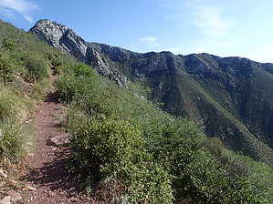


