 Route Editor

| Guide | ♦ | 2 Triplogs | 0 Topics |
details | drive | permit | forecast | 🔥 route |
stats |
photos | triplogs | topics | location |
| 12 | 2 | 0 |
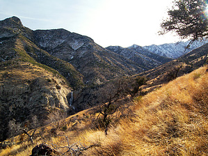
dead trails tell tales by PrestonSands   Overview OverviewThe Deadman Trail is one of several trails that tie into the Round The Mountain Trail #302, on the north slope of the Pinaleno Mountains. Beginning in high desert at the mouth of Deadman Canyon, the trail winds its way along grassy mountainsides, past waterfalls, and high peaks, and ends among the pines at Deadman Creek. Forest Road 6629 (the last 1.4 miles of road to the trailhead) is so rough and steep that most will likely prefer to hike this high clearance 4WD road rather than drive it. This additional stretch of road hiking is included in this hike's statistics. Statistics listed are for a one-way hike; a round trip hike is about 9.4 miles with 2774 feet AEG.
This trail is likely to be very hot during the summer months, as it stays on south-facing slopes; there is little, if any, shade until the last half mile. History Several versions exist concerning the origin of Deadman Canyon's name. One version says a fall victim was found here; another claims that a man died from an apparent rattlesnake bite. Perhaps the most credible tale is that of Presillino Monje, a packer for the U.S. Army, who was said to have died of pneumonia in the canyon and was buried there on March 23, 1873. Hike From its junction with Forest Road 650 (mile 0 for this description), begin hiking up Forest Road 6629, which heads southwest, following the narrow crest of a rocky ridge. After 1.4 miles and 800 feet of elevation gain, FR 6629 levels out in a saddle at the top of Deadman Mesa. The Deadman Trail, unmarked except for a wooden post, departs on the right side of the road in the saddle (at 32.74609 N, -109.80918 W). Leaving the saddle, the Deadman Trail ascends a little ridge into Deadman Canyon and soon passes through a gate with a "trail closed" sign (disregard, the trail is not closed). The trail remains rather faint for most of its length, with only a narrow path barely visible in the tall grass. The trail is well marked by frequent cairns, but you will have to stop and search for them at times. Within a mile, the little ridge the trail has been following transitions into a mountainside, and one can get their first good view up Deadman Canyon of the awaiting terrain. The trail clings to the grassy mountainside for some distance, negotiating a couple of minor side canyons. This stretch of the trail gives one a long look at a high waterfall, where Deadman Creek slides into a rocky gorge below. Framing this attractive scene are the unforgiving cliffs of mighty Deadman Peak. Approaching its upper end, the Deadman Trail enters oak woodland, and descends a bit to Deadman Creek. Pine trees begin to appear, and the trail heads up the narrow canyon bottom to meet the Round The Mountain Trail #302, at 4.7 miles. Camping A few small campsites can be found along the upper end of the Deadman Trail, along Deadman Creek. Gate Policy: If a gate is closed upon arrival, leave it closed after you go through. If it is open, leave it open. Leaving a closed gate open may put cattle in danger. Closing an open gate may cut them off from water. Please be respectful, leave gates as found. The exception is signage on the gate directing you otherwise.
Coronado FS Details If you look toward Mt. Graham from Safford, you'll notice that there is a lone mountain that stands between that higher range and the town. Though it's not as big as the Pinalenos, it may be even more rugged and precipitous than its taller neighbors. This is Deadman Peak. It is actually connected to Mount Graham by a high, sharp ridge that isn't obvious from the town and the highway. Trail #70 offers access to this rugged offshoot of the Pinalenos by leading up the drainage of Deadman Creek. This small stream tumbles down the north side of the mountain through a precipitous canyon which is home to a couple of waterfalls that are quite picturesque during spring flows. The trail remains within the confines of Deadman Canyon for its entire length, dropping down to the canyon floor for the last quarter of its journey to the Round the Mountain Trail #302. Vegetation along the trail is characteristic of the Upper Sonoran Desert zone except where the trail follows the floor of Deadman Canyon. Here, riparian species find a home along the stream which holds water for most of the year. Check out the Official Route and Triplogs. Leave No Trace and +Add a Triplog after your hike to support this local community. One-Way Notice This hike is listed as One-Way. When hiking several trails on a single "hike", log it with a generic name that describes the hike. Then link the trails traveled, check out the example. | |||||||||||||||||||||||||||||||||||||||||||||||||||||||||||||||||||||||||||||||||||||||||||||||||||||||||||||


