Route Editor

| Guide | ♦ | 38 Triplogs | 2 Topics |
details | drive | permit | forecast | route |
stats |
photos | triplogs | topics | location |
| 397 | 38 | 2 |
Mohave County Highpoint! by chumley  Important Mileage Note Important Mileage NoteStatistics for this hike are only for the spur hike to the peak from the Potato Patch Loop. Getting to and from the trailhead on the Potato Patch Loop will add 900 feet of elevation gain and 4.4 to 4.8 miles to this hike, depending on the direction you choose. The minimum distance you will hike round-trip from the trailhead to this peak is 7.9 miles. Additional miles may be added to your trip by hiking additional trails in the park. History The Hualapai Mountains are named after Native Americans who resided here until being relocated by the US Military in the 1870s. Trails in the mountains were constructed beginning in the 1930s by the CCC (Civilian Conservation Corps) and maintained and updated over time. Hual is the native term for Ponderosa Pine, meaning the Hualapai were the People of the Ponderosa Pines, or colloquially "Pine Tree Folk."
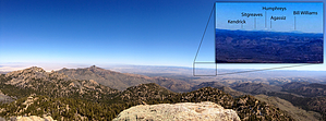
This old road heads southeast from the Potato Patch junction at park map point #8. It descends about 200 feet over the first half mile and then climbs gently to a saddle at the 0.75-mile mark. (This saddle marks the park boundary, and the hike's remainder is outside the park.) From the saddle, the old road turns to the southwest and ascends steeply directly toward the peak, climbing about 500 feet in half a mile before leveling off somewhat at about 1.25 miles. The respite is short-lived as the road begins to ascend toward the peak once again, this time going through several tight switchbacks. At 1.65 miles, you reach the last switchback, and while the road continues to the south about 200 yards, it is here that the easiest access to gain the summit begins on the east side of the peak. (The south side at the end of the road is a much more technical climb). Climb up the steep slope into the foliage-filled chute, negotiating boulders, scree, brush, and the only cactus I've ever seen growing at 8400 feet. Some class-3 scrambling will be required to gain the summit, where outstanding views in all directions will greet you. On a clear day, you can see the San Francisco Peaks, 130-miles to the east in Flagstaff. This is an out-and-back hike, so when you've had enough of the views, return the way you came.
Check out the Official Route and Triplogs. Note This is a moderately difficult hike. Leave No Trace and +Add a Triplog after your hike to support this local community. | ||||||||||||||||||||||||||||||||||||||||||||||||||||||||||||||||||||||||||||||||||||||||||||||||||||||||||||||||||||||||||||||||||||||||||||||||||||||||||||||||||||||||||||||||||||