Route Editor

| Guide | ♦ | 10 Triplogs | 0 Topics |
details | drive | permit | forecast | 🔥 route |
stats |
photos | triplogs | topics | location |
| 94 | 10 | 0 |
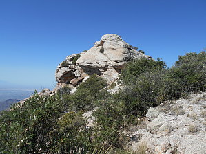
Class III “Bushwhack” by AZ_Step  Brinkley Point. First off, this is not a beginner’s hike. Although in the beginning, it may seem that way. I would consider it a Class III “Bushwhack” (long pants, gloves, hat, boots, map, compass/GPS, and over a mile of cross-country trail finding, very steep in some spots) (ropes are not required.. that would be a class IV Bushwhack). Brinkley Point. First off, this is not a beginner’s hike. Although in the beginning, it may seem that way. I would consider it a Class III “Bushwhack” (long pants, gloves, hat, boots, map, compass/GPS, and over a mile of cross-country trail finding, very steep in some spots) (ropes are not required.. that would be a class IV Bushwhack).The trail from Box Camp trailhead to the turn-off for Box Springs it’s nice and easy to follow. Just after the turn-off to Box Springs, the trail starts to become overgrown. It’s not hard to follow, but the vegetation overruns the trail in quite a few places, and several downed trees need to be crossed. At the saddle, the trail forks, you can’t see the fork, but it’s there. If you continue following the trail west, you will go to Box Springs. The trail to Brinkley Point follows the ridgeline to the south. If you can’t find the trail, follow the ridgeline.
The last quarter mile to the Point is relatively easy and has excellent views in all directions. At the point, there is a US Geological Survey Marker (Elevation 7073 ft) and a Trail Registry in a glass jar. You can see Thimble Peak to the south, Cathedral of Rock to the south-west, and Lemmon lookout to the north. And off in the far distance, you can see Baboquivari Peak in the southwest. At one time, this would have been a nice easy trail and an excellent place to have lunch. It would be nice if the forest service brought it back. Check out the Official Route and Triplogs. Leave No Trace and +Add a Triplog after your hike to support this local community. | |||||||||||||||||||||||||||||||||||||||||||||||||||||||||||||||||||||||||||||||||||||||||||||