 Route Editor

| Guide | ♦ | 15 Triplogs | 0 Topics |
details | drive | permit | forecast | 🔥 route |
stats |
photos | triplogs | topics | location |
| 125 | 15 | 0 |
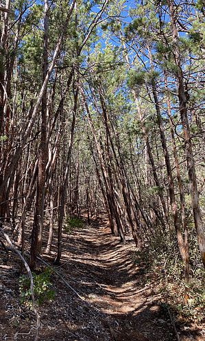
Bears? What bears? by GrangerGuy   Overview OverviewThe Bear Sign Canyon Trail #59 is within the Coconino National Forest, Red Rock Secret Mountain Wilderness. Although little used, it is in good shape and follows the Bear Sign Canyon for about 3.5 miles to some pretty camping spots. The trail also forms a segment of the Bear Sign – Secret Canyon Loop. Access The Bear Sign Trail starts about 0.9 miles up the Dry Creek Trail. To get to the Vultee Arch / Dry Creek Trailhead, you have to head up Dry Creek Road 152 from the Dry Creek Vista TH, popular for Devil’s Bridge. This requires either a 4-mile walk or a slow drive in a high clearance 4WD vehicle. At one time, this FR152 was drivable by sedan, but today requires 4WD. If you can confidently negotiate the rock berm at the entrance to the road, you can make it the rest of the way.
I chose to walk the road. The Dry Creek Vista TH parking lot requires a Red Rock Pass or multi-agency pass. It was full to overflowing even at 7 am on a Saturday, and I ended up parking overnight on Boynton Pass Rd. There is a pit toilet at the parking lot. If you drive all the way to the trailhead, there is sufficient parking at the Vultee Arch / Dry Creek Trailhead for several vehicles. Hike From the Dry Creek Trailhead, hike more or less west to Dry Creek, passing in and out of the wilderness. Soon the trail stays within the wilderness. I found good water at Dry Creek in April of 2021, and off and on along Bear Sign Canyon as well. About 0.75 mi up Dry Creek Trail, the Bear Sign Trail heads off to the left. The trail climbs up above Bear Sign Canyon Creek, and alternately drops down into it, but never is far from the creek. As the trail climbs up, it enters some beautiful forest of Pine, Arizona Cypress, Manzanita, and Scrub Oak. I found the trail pleasantly shady on an April morning. About a quarter mile up the trail, it becomes a little hard to follow the trail where it crosses the creek, but usually, navigation is not difficult. There is some beautiful red rock along this trail. There is an especially beautiful place where the creek has carved the rock about 1 mile up the trail. About 1.8 miles up the trail, there is a large sandstone sentinel rock on the right hand side of the creek. The trail climbs up out of the creek bed and around it to the right. Soon after this, there is the likeness of a face naturally occurring in the rocks on the right, guarding the trail. At 2.3 miles, the David Miller Trail heads sharply up the hill to the left. The Bear Sign Canyon Trail continues. About a quarter mile after the David Miller Trail, where two canyons intersect, there are the remains of a significant debris flow. The trail crosses the right hand drainage and heads up between the two drainages. The trail may be a little hard to follow here, so pay attention. There are some tree blazes to mark the path. At about 3.3. miles, the canyon opens up to some decent campsites. This is the end of the mapped trail, but a cairned path continues up the canyon. I’ll leave that for other adventurers. There are a lot of inexperienced tourists on FR 152. Coming in and going out, I encountered people who were lost. Be kind, and be prepared to help them find their way back. The Red Rock Secret Mountain Wilderness was part of the 1.1 million acre Arizona Wilderness Act of 1984, sponsored by Reps. Mo Udall and James Francis Mcnulty. It protected a large swath of national forest lands under the National Wildernss Preservation System. Flora There is great diversity on this trail. The Arizona Cypress has a woody cone, a ball about ¾ inch in diameter. There is a lot of it along this trail. It also has a very “hairy” bark. It is quite a noticeable tree. About 2 miles up the trail the forest evolves into Alligator Juniper, a big leaf Oak, Ponderosa Pine and Douglas Fir. Even some Bigtooth Maple can be found. There is a plant that looks a great deal like coastal salal, but this is out of its normal range, so I am not convinced. Fauna I did not see any bear sign on this trail. Others claim they have seen it.
Check out the Official Route and Triplogs. Leave No Trace and +Add a Triplog after your hike to support this local community. One-Way Notice This hike is listed as One-Way. When hiking several trails on a single "hike", log it with a generic name that describes the hike. Then link the trails traveled, check out the example. | |||||||||||||||||||||||||||||||||||||||||||||||||||||||||||||||||||||||||||||||||||||||||||||||||||||||||||||||||||||||||||||||||||||||||||||||||||||||||||||||||||||||||||||||||||||||||||||||||||||||||||||


