This is an out and back beginning at the Catalina State Park trailhead parking lot. As you approach the main trailhead, you’ll see a trail to the left, running just inside a split rail fence. This is your trail, so get going :D
The trail switches back and forth, but primarily runs north-northeast for the first segment. At 0.7 miles in, you’ll come to a junction in a wash bottom. Be sure to hang left here. I mention this as I have missed my turn here more than once. Now it’s 2 more miles of mild and scenic trail to finish out this segment where you merge onto the Sutherland jeep trail. From here, you head due east for 0.9 miles. This segment is fortunately short as it isn’t very pleasant. This “jeep” trail isn’t even well-liked by many jeeps, but this stretch is quickly behind you.
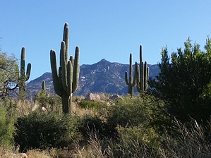
Now, I don’t want to over elevate your expectations, so don’t be thinking ‘Grand Canyon’, but instead a pleasant day on a lightly used trail that offers new views and perspectives of the Catalina’s western range. You are about 3.8 miles into it when you arrive at the Baby Jesus Trail splitting from the jeep trail and heading north-northwest. In 0.8 miles you’ll arrive at a concrete spring box filled by the nearby Wooden Trough Spring. If you happen to be here at the right time of the year it may even have a few goldfish in it. As you leave the spring you’ll head along a crooked northerly path that ungulates pleasantly over the soft foothills below Samaniego Peak, reaching its peak elevation of 3,885’ at just about 1.5 miles from the jeep trail. From here the trail arcs from north to the northwest as you drop away from the ridgeline working ultimately toward the canyon floor. The end of the trail will all of a sudden be right there in front of you as it opens up into a system of jeep and ATV trails. This junction is a very nice spot with a lot of shade to rest in before your return.
WARNING! Hiking and outdoor related sports can be dangerous. Be responsible and prepare for the trip. Study the area you are entering and plan accordingly. Dress for the current and unexpected weather changes. Take plenty of water. Never go alone. Make an itinerary with your plan(s), route(s), destination(s) and expected return time. Give your itinerary to trusted family and/or friends.
Permit $$
AZ State Parks more info
2026 Day Use Fees range from $5–$30
Per vehicle (1 person): $10.00
Per vehicle (2-4 people): $20.00
Individual/bicycle: $5.00
$200 Annual Pass
Coronado Forest MVUMs are rarely necessary to review unless mentioned in the description or directions Coronado Motor Vehicle Use Maps (MVUMs)
Directions
Road
Paved - Car Okay
To Catalina State Park Trailhead From Phoenix take 1-10 south to the 241 exit (Tangerine). Follow east to AZ 77 (Oracle Road). Turn right (South) on AZ77 and signs for Catalina State Park lead the way.
From anywhere in Tucson, connect to Oracle Rd (Highway 77) and head north past Pusch Ridge. After you have gone about 15-20 miles you will see the sign for Catalina State Park on the right. There is an entrance fee to get into the park. To get to the trails, just drive in and follow the signs to a large parking area marked "trailhead".
From PHX (I-10 & AZ-51) 107 mi - about 1 hour 44 mins From TUC (Jct 1-10 & Grant) 14.0 mi - about 23 mins From FLG (Jct I-17 & I-40) 251 mi - about 3 hours 50 mins
 Route Editor

 This is an out and back beginning at the Catalina State Park trailhead parking lot. As you approach the main trailhead, you’ll see a trail to the left, running just inside a split rail fence. This is your trail, so get going :D