Brushy Canyon Trail #355, AZ | HikeArizona
   🔥

Brushy Canyon Trail #355, AZ

Guide 0 Triplogs Mine 0 0 Topics
 
0 of 5 
Fav
Wish
0
details
drive
permit
forecast
🔥
route  
stats
photos
triplogs
topics
location
7 0 0
Statistics
tap icons for details
Difficulty 2.5 of 5
Distance One Way 2.6 miles
Trailhead Elevation 6,000 feet
Elevation Gain 808 feet
Accumulated Gain 808 feet
Avg Time One Way 2 hours
Kokopelli Seeds 5.29
 Backpack Yes & Connecting
feature photo
Photos Viewed All MineFollowing
7  2017-12-13 Guy
Author
author avatar Guides 16,880
Routes 17,280
Photos 24
Trips 1 map ( 6 miles )
Age 26 Male Gender
Location HAZ, TrailDEX
Associated Areas
list map done
Tucson Region
Historical Weather
Trailhead Forecast
Radar Map
Expand Map
Preferred Apr, Oct, Mar, May → Early
Seasons   Spring to Autumn
Sun  6:56am - 6:07pm
Official Route
 
0 Alternative
 
 Water
Historic Fire Perimetersacres
🔥 2017 Rucker Fire5.2 mi*
🔥 2011 Horseshoe 2 Fire158.9 mi*
🔥 1994 Rattlesnake Fire50.4 mi*
🔥 View (All) - over Official Route 🔥
*perimeter length in miles
Nearby Area Water
[ View More! ]
no photo labels yet
+Add > Photos to this Guide
then label as applicable
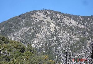
Trailhead to Trailhead
by HAZ_Hikebot

Turtle Mountain Trail #219 offers a primitive route to the summit of soaring Monte Vista Peak out of Sycamore Canyon. You can combine it with the Monte Vista Trail #221 and Brushy Canyon Trail, in the appropriately named Brushy Canyon, to form a loop through this high and scenic region of the southern Chiricahuas. The Turtle Mountain Trail is exceptionally steep in several places, especially where it climbs up and over the rocky rim of Sycamore Canyon. At times you may find yourself feeling that its name comes as much from the pace one sets in traveling it as it derives from the shape of nearby Turtle Mountain.
After you climb out of Sycamore's inner gorge, scramble to a steep saddle, and curve around the northwestern shoulder of Turtle Mountain, 9,357 foot Monte Vista Peak comes into view and stays there for the rest of the journey to its summit. When you reach the summit, you will have a view of a panorama that stretches well into Mexico and encompasses much of southeastern Arizona and a healthy portion of southwestern New Mexico.

To turn your journey into a round trip, you can return the way you came or drop down the Monte Vista Trail into North Fork Canyon. That way, you'll get to enjoy one last look at all those fabulous views. From the Monte Vista Trail end, travel down North Fork Road about one-half mile to Brushy Canyon Trailhead. The Brushy Canyon Trail goes up and over a divide into Brushy Canyon on its way back to the Turtle Mountain Trailhead in Sycamore Canyon.

Check out the Official Route.

Leave No Trace and +Add a Triplog after your hike to support this local community.

2008-06-13 HAZ_Hikebot

    One-Way Notice
    This hike is listed as One-Way.

    When hiking several trails on a single "hike", log it with a generic name that describes the hike. Then link the trails traveled, check out the example.
    WARNING! Hiking and outdoor related sports can be dangerous. Be responsible and prepare for the trip. Study the area you are entering and plan accordingly. Dress for the current and unexpected weather changes. Take plenty of water. Never go alone. Make an itinerary with your plan(s), route(s), destination(s) and expected return time. Give your itinerary to trusted family and/or friends.

     Permit $$
    None

    Coronado Forest
    MVUMs are rarely necessary to review unless mentioned in the description or directions
    Coronado Motor Vehicle Use Maps (MVUMs)


     Directions
    or
    or
     Road
    TBD

    To Brushy Trailhead
    From Tucson, take I-10 east 72 miles to US 191. Turn right (south) and drive 29 miles to the turnoff to Rucker Lake. Turn left (east) and drive 17 miles to the Forest boundary. Continue on FR 74 for 5 miles to FR 74E. Turn left (north) on FR 74E and drive 2 miles to FR 4244. Turn left (north) on FR 4244 and go to end of road.

    From Douglas, take Leslie Canyon Road north to Rucker Canyon. Stay on the main road, which becomes FR 74 at the Forest boundary. Continue on FR 74 for 5 miles To FR 74E. Turn left (north) on FR 74E and drive 2 miles to FR 4244. Turn left (north) on FR 4244 and go to end of road.

    Road condition is unknown, clarification needed. Best go in with a 4x4 until further information is obtained.

    From PHX (I-10 & AZ-51) 238 mi - about 4 hours 50 mins
    From TUC (Jct 1-10 & Grant) 128 mi - about 3 hours 15 mins
    From FLG (Jct I-17 & I-40) 381 mi - about 6 hours 56 mins
    page created by joebartels on Jun 13 2008 3:48 pm
    helpcorrectionissue

    end of page marker