This trail is not only easy to get to, but it provides a relatively moderate hike to some of the best views in the Huachucas. In the process, it also offers access to two of the highest points in southeastern Arizona, Carr Peak and (via the Crest Trail #103) Miller Peak. For these reasons, this combination of trails provides some of the most popular hiking in the Sierra Vista District.
Carr Peak Trail is conveniently accessible from the Reef Townsite Campground and Ramsey Vista Campground on scenic Carr Canyon Road. The main trailhead is located at the edge of a parking area just outside Ramsey Vista Campground. Other means of access are provided by a short spur that comes directly out of the Ramsey Vista Campground and the Old Sawmill Spring Trail from the parking lot across FR 368 from the Reef Townsite Campground.
Much of the 2,000-foot climb from the trailhead to the summit is through an area that has been burned by at least two wildfires, one in 1977 that scorched much of the upper reaches of the mountain range and a smaller one in 1991. These areas of disturbance are well on their way to healing naturally as various shrubs, trees, and wildflowers return to reclaim them. In places where you could find only ashes, burnt snags, and bare dirt a short time ago, healthy communities of young aspens are already putting on brilliant displays of fall colors.
The trail offers good views of the upper reaches of Carr Peak and Miller Peak across Miller Canyon. To get to the top of Carr Peak (9,230'), you'll need to follow the short but steep Carr Peak Spur. The main trail continues on to connect with the Crest Trail, which offers access to Miller Peak and the rest of the Huachuca Mountains trail network.
When hiking several trails on a single "hike", log it with a generic name that describes the hike. Then link the trails traveled, check out the example.
WARNING! Hiking and outdoor related sports can be dangerous. Be responsible and prepare for the trip. Study the area you are entering and plan accordingly. Dress for the current and unexpected weather changes. Take plenty of water. Never go alone. Make an itinerary with your plan(s), route(s), destination(s) and expected return time. Give your itinerary to trusted family and/or friends.
Permit $$
None
Coronado Forest MVUMs are rarely necessary to review unless mentioned in the description or directions Coronado Motor Vehicle Use Maps (MVUMs)
Directions
Road
FR / Dirt Road / Gravel - Car Okay
To Carr Trailhead Drive south of Sierra Vista 7 miles on Arizona Highway 92 to the Carr Canyon Road (FR 368). Follow FR 368 about 6.5 miles to the Old Sawmill Spring trailhead across from the entrance to Reef Townsite Campground. The Carr Peak Trailhead is located at a parking lot just outside the entrance to Ramsey Vista Campground at the end of FR 368. Carr Peak Spur is accessible via the Carr Peak Trail.
From PHX (I-10 & AZ-51) 199 mi - about 3 hours 19 mins From TUC (Jct 1-10 & Grant) 89.7 mi - about 1 hour 44 mins From FLG (Jct I-17 & I-40) 343 mi - about 5 hours 25 mins
 Route Editor

 This trail is not only easy to get to, but it provides a relatively moderate hike to some of the best views in the Huachucas. In the process, it also offers access to two of the highest points in southeastern Arizona, Carr Peak and (via the Crest Trail #103) Miller Peak. For these reasons, this combination of trails provides some of the most popular hiking in the Sierra Vista District.
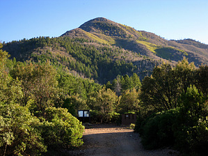


