Overview
From reviewing the many HAZ White Tank triplogs, this route is the standard final push for many trekkers when achieving the summit of BGP 4083. The Official Route involves following an indistinct ridgeline path for half its length and then the other half is a wide berthed walk up the final steep section of the North Tower Road.
Hike
The start tees off the Goat Camp Trail at the five-and-a-quarter mile point (measured from the Goat Camp TH). It's also possible to reach this junction from the Ford and Mesquite Canyon Trails, a bit over one-mile southwest of where these two trails merge with the terminus of the Goat Camp Trail.
This unsanctioned trail will seem more obscure than any of the official trails one has just ascended to this point, but it requires minimal route finding to stay on track. You'll hike amongst Prickly Pear, Strawberry Hedgehog, and Staghorn Cholla (to name a few) on the Saguaro-less north side of an eastern descending prow. There are also a few saddles one will cross before merging onto the main road. It's another 0.7 miles up to the antennaed White Tank Mountains highpoint.
When hiking several trails on a single "hike", log it with a generic name that describes the hike. Then link the trails traveled, check out the example.
WARNING! Hiking and outdoor related sports can be dangerous. Be responsible and prepare for the trip. Study the area you are entering and plan accordingly. Dress for the current and unexpected weather changes. Take plenty of water. Never go alone. Make an itinerary with your plan(s), route(s), destination(s) and expected return time. Give your itinerary to trusted family and/or friends.
 Route Editor

 Overview
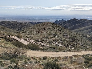


