username
X
password
register
for free!
help


White Tank Mountains Radio Summit 4018, AZ

Guide 12 Triplogs  0 Topics
  3 of 5  
Fav
Wish
0
details
drive
no permit
forecast
route  
stats
photos
triplogs
topics
location
42 12 0
Statistics
tap row or icons for details
Difficulty 1.5 of 5
Route Finding 1 of 5
Distance One Way 0.77 miles
Trailhead Elevation 3,167 feet
Elevation Gain 840 feet
Accumulated Gain 840 feet
Avg Time One Way 1 hour
Kokopelli Seeds 3.57
 Interest Peak
 Backpack Possible - Not Popular
feature photo
Photos Viewed All MineFollowing
Inaugural Calculation on Button Tap!
11  2025-01-10 mt98dew
3  2024-04-05
Barry Goldwater Peak via Goat Camp
pseudalpine
8  2013-09-29
Barry Goldwater Peak via Mesquite Canyon
trekkin_gecko
2  2012-01-23
White Tank Loop w/Peaks
PatrickL
18  2010-03-27
White Tank Mtns Radio Summit via Goat Camp
The_Eagle
Author
author avatar Guides 59
Routes 1,100
Photos 1,176
Trips 1,290 map ( 9,859 miles )
Age Male Gender
Location Arizona
Associated Areas
list map done
Phoenix Region
Historical Weather
Trailhead Forecast
Radar Map
Expand Map
Preferred Nov, Dec, Jan, Feb → 7 AM
Seasons   Autumn to Spring
Sun  6:06am - 6:52pm
Official Route
 
5 Alternative


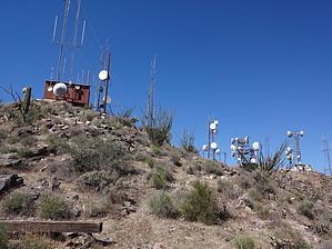
Feel the Double 5G Burn
by pseudalpine

 
Overview
This is one of the other unsanctioned connector trails that gains another verboten peak in the White Tank Mountains Regional Park. Of course, it's second fiddle (-65 feet) to Barry Goldwater Peak, but remains a worthy bonus summit that can be completed in tandem by looping from/to 4083 without much-added effort.


Hike
When ascending from the Goat Camp TH, this trail splits left (west) just past mile three. It's a faint path that continually steepens during the ascent of a predominantly east-facing ridgeline to the broad mountaintop. This Microwave Radio Towers labeled area can also be approached from the west via the North Tower Road, which involves approximately an 0.81-mile and +537 AEG ascent.
remove free decal offer
Synopsis
If you're up there anyway in an officially mapped ATTENTION - NO ACCESS! area, you might as well make the most of your furtive hike and also complete this decent subordinate peak.

Note: HAZ reminds you to obey all laws on certified signage.

2024-04-07 pseudalpine
  • 2019 White Tank Trails Map
    area related
    2019 White Tank Trails Map
  • 2019 White Tank Mtns Closeup Map
    area related
    2019 White Tank Mtns Closeup Map


Check out the Official Route and Triplogs.
Leave No Trace and +Add a Triplog after your hike to support this local community.

One-Way Notice
This hike is listed as One-Way.

When hiking several trails on a single "hike", log it with a generic name that describes the hike. Then link the trails traveled, check out the example.
WARNING! Hiking and outdoor related sports can be dangerous. Be responsible and prepare for the trip. Study the area you are entering and plan accordingly. Dress for the current and unexpected weather changes. Take plenty of water. Never go alone. Make an itinerary with your plan(s), route(s), destination(s) and expected return time. Give your itinerary to trusted family and/or friends.

 Permit $$
None


 Directions
or
 Road
Connector trail - Not Applicable

To hike
Connector trail: Not applicable, review Hike section of guide for details.
page created by joebartels on Apr 07 2024 4:43 pm
 90+° 8am - 6pm kills
helpcorrectionissue

end of page marker