 Route Editor

| Guide | ♦ | 38 Triplogs | 1 Topic |
details | drive | permit | forecast | 🔥 route |
stats |
photos | triplogs | topic | location |
| 522 | 38 | 1 |
Peak Without a View by markthurman53   Chiricahua Peak 9,742 - Cochise County high point Chiricahua Peak 9,742 - Cochise County high pointCREST TRAIL OVERVIEW The Crest Trails north end is along the Barfoot Park Road and continues southward to Chiricahua Peak, Sentinel Peak, and Monte Vista Peak. This trail is 14.2 miles long and divided into three sections, each traversing a ridge or crest. From Chiricahua Peak, there are three main ridges; to the north, a ridge running to Buena Vista Peak, to the southwest, a ridge running to Monte Vista Peak, and to the southeast, a ridge running to Sentinel Peak. Each of the ridges divides the trail into three sections and two side trails. THREE MAIN ⅄ LEG SECTIONS
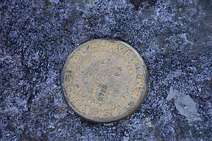
6.2 miles: on the north side of Chiricahua Peak #270B - Jct Sdl to Monte Vista Pk 3 miles: Along the west side of Chiricahua Peak #270C - Jct Sdl to Sentinel Peak 5 miles: Along the east side of Chiricahua Peak TWO SHORT OPTIONS #270A - Jct Sdl to Aspen Sdl Jct Saddle > Chiricahua Pk > Aspen Sdl 0.9 miles: on the SE side of Chiricahua Pk #270D - Chiricahua Bypass 1.2 miles: Aspen Sdl to Chiricahua Sdl along the south side of Chiricahua Pk Access to the Crest Trail at various points can be done from Rustler Park to the north, Turkey Creek to the west, Cave Creek to the east, and Rucker Canyon to the South. Only the Rustler Park access is direct; the rest require 5 to 10-mile connecter trails with 3 to 4000 feet of elevation change. These Trails are all at around 9000 feet through heavily wooded areas, and some areas burned pretty severely over the last 20 years. The forest is in different stages of recovery. Weather can change suddenly at this elevation, and if on the trail, be prepared for whatever it can throw at you; there is no quick exit from this trail. CREST TRAIL #270A –CHIRICAHUA PEAK Overview Chiricahua Peak is the highest peak in the Chiricahua Mountains at 9795 feet. Fires over the last 15 years burned the northwest and southeast sides of the peak and are now in the process of recovering with aspen trees. Because of this, the views on the way up are phenomenal; don’t expect any at the peak because of the trees. On a clear day, Mount Wrightson, Rincon Mountains, Mount Lemmon, and Mount Graham, pretty much all of southeast Arizona, are visible along with mountains in Mexico and New Mexico. In my research on this peak, I found out that this is the southernmost stand of Engelman Spruce in the world, but I wouldn’t know an Engelman Spruce if it fell on me. There is no vehicle access to this trail but the easiest access is along the Crest Trail #270 from Rustler Park. Description The Chiricahua Peak Trail #270A starts at a Signed intersection of the Crest Trail at Junction Saddle. The Crest Trails #270, #270B, and 270# C all meet on this saddle. A trail sign that has seen better days is bolted to a tree that didn’t survive the fire but hasn’t given up on standing tall. From the saddle the trail heads into a grove of young aspen trees, the trail is visible but the aspen trees branches obscure the trail a bit. On one of my trips there was a bear and her cub fairly close but the aspen trees were so thick I think I heard them scurry off more than saw them. There are clear sections along this trail and from them the views to the northwest are great. The last tenth mile is through pine and fir trees and probably that Engelman Spruce that I just referred to as Fir trees. Don’t expect much at the top; in fact, I spent a little time trying to determine where the top was until I spotted the survey marker saying I was at 9795 feet. There is a trail that heads down the southeast slope to Aspen Saddle. I’ve included this trail as part of the Chiricahua Peak Trail #270A because it appears to be a frequently traveled trail, not as good a shape as the northwest approach but easy enough to follow. The northwest approach is a 300-foot climb whereas the southeast approach is 350 feet. The southeast slope was burned at the same time the northwest slope was but this side of the peak is not covered in aspen, therefore the views over Rucker Canyon are good. The views all along the ridges that the Crest Trail #270B & C traverse are clearly visible. At Aspen Saddle is the junction with the Crest Trail #270C and the Ojo Agua Fria Trail #361. Check out the Official Route and Triplogs. Leave No Trace and +Add a Triplog after your hike to support this local community. One-Way Notice This hike is listed as One-Way. When hiking several trails on a single "hike", log it with a generic name that describes the hike. Then link the trails traveled, check out the example. | ||||||||||||||||||||||||||||||||||||||||||||||||||||||||||||||||||||||||||||||||||||||||||||||||||||||||||||||||||||||||||||||||||||||||||||||||||||||||||||||||||||||||||||||||||||||||||||||||||||||||||||||||||||||||||||


