 Route Editor

| Guide | ♦ | 8 Triplogs | 0 Topics |
details | drive | permit | forecast | route |
stats |
photos | triplogs | topics | location |
| 88 | 8 | 0 |
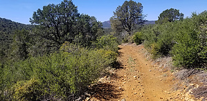
Peaceful easy OHV feeling by joebartels   Prospectors Trail #42 has no trailhead. Access via Prospectors Trail #42 has no trailhead. Access viaNW - Salida Connection Trail #9263 N - White Horse Tank Trail #354 W - Red Mountain Trail #43 S - Salida Trail #93 All except #93 have a trailhead OHV - Tread Like many Bradshaw trails, this is an OHV trail that some hikers avoid. Off-highway vehicles may not exceed 50 inches in width. This wide trail is catclaw and brush-free. The footing in many stretches is loaded with small rocks dubbed ankle-busters. Ascending is typically safer for hikers; I hiked both directions without any issues.
Since the northwest access is the only access from a single trail and the footing is better ascending, this guide reads northwest to south. Heading up, the only claim I spotted was within a few strides. White Horse Tank Trail #354 turns left at 0.15-miles. A possible area to explore is at 0.4-miles. By 0.75-mi/220 ft vegetation increases. The most iconic view is looking back at Granite Mountain just 15 miles away. The trail drops 140 ft then up 170 ft and you pass through a gate at 1.3-mi just before a junction with Red Mountain Trail #43. That was the northwest leg. The southern leg continuing was my favorite. It is a flat, broad ridge with occasional nice distant views and more shade from tall pines. Bull Tank is nothing to get excited about but within the final half-mile is pretty nice. Synopsis It won't be on my wishlist, but a solid low 3 out of 5 in my book in breezy 79 degrees. Check out the Official Route and Triplogs. Leave No Trace and +Add a Triplog after your hike to support this local community. One-Way Notice This hike is listed as One-Way. When hiking several trails on a single "hike", log it with a generic name that describes the hike. Then link the trails traveled, check out the example. | |||||||||||||||||||||||||||||||||||||||||||||||||||||||||||||||||||||||||||||||||||||||||||||||||||||||||||||||||||||||||||||||||||||||||||||||||||||||||||||||||||||||||||||||


