 Route Editor

| Guide | ♦ | 7 Triplogs | 0 Topics |
details | drive | permit | forecast | route |
stats |
photos | triplogs | topics | location |
| 213 | 7 | 0 |
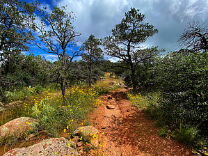
crowdless, brush-free, mountain views, trees by joebartels   Overview OverviewThe easier accessible NW begins at the end of Salida Connection Trail #9263. Prospectors Trail #42 also begins from this junction and is a good short-loop option. The SE end of Salida Trail #93 is at the 3.7-mi point of Charcoal Gulch Trail #9419. Warning This trail is open to motorized and non-motorized traffic. In theory, bikes and motorcycles are supposed to yield to hikers. Use your best judgment, and practice jumping to the side. Fear not, the tread will likely scare you away before you encounter fellow human life.
Salida Trail #93 sports impressive rollercoaster grades over ridges and dipping through ravines. The tread loaded with ankle-buster rocks is not for the timid. Primarily a juniper forest with ponderosa pine and occasional Gambel oak shade relief. The trail contours a ridge 0.4-mi to a ravine with Salida Tank. Don't be fooled, the rollercoaster begins faster than you can type like for a like. By 0.9-mi, creative compound verbiage surfaces ascending the ankle-buster tread on an 18.9% grade for 0.2-mi. Camelback is a crowded 23% grade surrounded by lung-chocking smog for reference. Hold up celebrating good times cresting a ridge at 1.1-mi. That was freshman mixer. You drop 50-ft and then it's mostly up to 2.8-mi. Prospectors Trail #42 heads north at 1.95-mi, Quail Tank is a few strides further at 2.0-mi. If your mother didn't raise a ninny and you have an ounce of explorer in you, check out James Well. The negatives weigh heavy but there are several nice stretches of trail. We utilized a nice outcrop at 2.8-mi for a lunch break and there are several fab views of Granite Mountain along the trail. 2.85 to 3.25-mi is easy contouring Bear Down 6962. The balance to 4.15-mi is nothing to fret about either. Dewey Humbolt comes into view en route. Trail #93 ends at an emotionless junction with Charcoal Gulch Trail #9419. Trail #9419 can be used with Red Mountain Trail #43 and Prospectors Trail #42 for a medium-sized loop. Avid hikers can create a larger loop throwing Nemo Spring Trail #9405 into the mix. Pick a day when temps are below 70° for the larger loop, it's not world-class. Camping A couple of nice options. However, the package deal will not appeal to the masses. Synopsis If you are an avid hiker in search of less-used trails and can tolerate ankle-buster rocks, this is a worthy trail once or you can scratch adventurer and explorer off your social posts. It's a locust-free, catclaw-free trail with better than average distant views with looping options.
Check out the Official Route and Triplogs. Leave No Trace and +Add a Triplog after your hike to support this local community. One-Way Notice This hike is listed as One-Way. When hiking several trails on a single "hike", log it with a generic name that describes the hike. Then link the trails traveled, check out the example. | |||||||||||||||||||||||||||||||||||||||||||||||||||||||||||||||||||||||||||||||||||||||||||||||||||||||||||||||||||||||||||||||||||||||||||||||||||||||||||||||||||||||||


