Originally called Millsite Canyon, after a sawmill located high in the mountains.
A fine riparian area, plenty of evidence of the area's mining past, and good views from the Huachuca Crest are some of the rewards you'll reap along this trail. After detouring around a piece of private property, the trail drops back into Miller Canyon to follow what was once an old mining road. The trail passes the remains of the townsite of Palmerlee and several abandoned mining digs as it slants steadily up the canyon. Down in the bed of Miller Creek, which usually has water in it year-round, you'll be able to see lengths of the old carbon steel pipe which were placed here in the nineteenth century to carry water to the boomtown of Tombstone.
Along lower stretches of the trail, large old Arizona Sycamore trees shade the streambed, and sunlight filters down through the limbs of tall Douglas-firs. There are bigtooth maples along the streambed in this area, too, making it a colorful place to visit in mid to late October when the leaves of these trees paint the canyon in hues of orange, red, and yellow. After crossing the stream several times, the trail switchbacks its way up the north side of the canyon into an area that was burned by a large forest fire in 1977. Here, you'll find good views down-canyon of the San Pedro Valley and the Mule Mountains around Bisbee while Miller Peak stands high above the canyon rim to the southwest. From this point, the trail continues to climb, visiting the stream a couple of more times and passing several more old mine sites before it intersects the Crest Trail #103 high in the Huachucas.
Views of peaks and valley. Historic mining area. Fall colors. Access to Huachuca Crest. 3.3 miles of this trail are within the Miller Peak Wilderness. Purification of water is recommended before use.
Impacted by the Monument fire and post-fire rains, especially in the first mile from the trailhead. In November 2011 CREC (Coconino Rural Environment Corps) started work from the junction of the Crest trail down, rebuilding about a mile of the trail. The trail maintenance has been completed as of April 2012, new signs have been installed.
When hiking several trails on a single "hike", log it with a generic name that describes the hike. Then link the trails traveled, check out the example.
WARNING! Hiking and outdoor related sports can be dangerous. Be responsible and prepare for the trip. Study the area you are entering and plan accordingly. Dress for the current and unexpected weather changes. Take plenty of water. Never go alone. Make an itinerary with your plan(s), route(s), destination(s) and expected return time. Give your itinerary to trusted family and/or friends.
Permit $$
no fees or permits reported
if incorrect tell us about it
Coronado Forest MVUMs are rarely necessary to review unless mentioned in the description or directions Coronado Motor Vehicle Use Maps (MVUMs)
Directions
Road
FR / Dirt Road / Gravel - Car Okay
To Miller Trailhead Drive south of Sierra Vista on AZ Highway 92 about 9 miles to the Miller Canyon Road (FR 56). Follow FR 56 to the parking area at the end of the road.
From PHX (I-10 & AZ-51) 199 mi, 3 hours 9 mins From TUC (Jct 1-10 & Grant) 89.9 mi, 1 hour 38 mins From FLG (Jct I-17 & I-40) 343 mi, 5 hours 17 mins
 Route Editor


 Originally called Millsite Canyon, after a sawmill located high in the mountains.
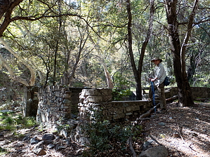


